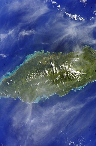
Upolu is an island in Samoa, formed by a massive basaltic shield volcano which rises from the seafloor of the western Pacific Ocean. The island is 75 kilometres long and 1,125 square kilometres in area, making it the second largest of the Samoan Islands by area. With approximately 145,000 inhabitants, it is by far the most populous of the Samoan Islands. Upolu is situated to the southeast of Savai'i, the "big island". Apia, the capital, is in the middle of the north coast, and Faleolo International Airport at the western end of the island. The island has not had any historically recorded eruptions, although there is evidence of three lava flows, dating back only to between a few hundred and a few thousand years ago.

The Samoan Islands are an archipelago covering 3,030 km2 (1,170 sq mi) in the central South Pacific, forming part of Polynesia and of the wider region of Oceania. Administratively, the archipelago comprises all of the Independent State of Samoa and most of American Samoa. The land masses of the two Samoan jurisdictions are separated by 64 km (40 mi) of ocean at their closest points.
Samoa is made up of eleven itūmālō. These are the traditional eleven districts that were established well before European arrival. Each district has its own constitutional foundation (faavae) based on the traditional order of title precedence found in each district's faalupega.

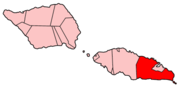
Ātua is an ancient political district of Samoa, consisting of most of the eastern section of Upolu and the island Tutuila. Within Samoa's traditional polity, Ātua is ruled by the Tui Ātua together with the group of six senior orators of Lufilufi and 13 senior matai from throughout Ātua, comprising the Fale Ātua. The fono (meeting) of Atua's rulers takes place in Lufilufi on the great malae of Lalogafu'afu'a.
Tuamāsaga is a district of Samoa, with a population of 95,907. This makes it the most populous district in Samoa. The geographic area of Tuamasaga covers the central part of Upolu island, and includes the capital, Apia.

Vavau is a small village on south east end of Upolu island in Samoa. The village is part of the Lotofaga Electoral Constituency which is within the larger political district of Atua.
Sataoa is a small village situated on the central south coast of Upolu island in Samoa. Like many villages in the country, Sataoa has two settlements, one inland and one by the coast. The population of Sataoa Uta is 1121 and Sataoa Tai is 239.

Mulinuʻu is a small village situated on a tiny peninsula on Upolu island in Samoa. It became the site of the colonial administration in Samoa in the 1870s and continues to be the site for the Parliament of Samoa. It is located on the central north coast of the island and is part of the urban area comprising Apia, the country's capital.

Falefā is located on the north eastern coast of Upolu island in Samoa. It was the ancient capital during the ‘Malo’ (‘government’) of Tupu Tafa'ifa (King) Fonoti. After having defeated his nephew Toleafoa and sister Samalaulu for control of Samoa King Fonoti chose to rule from his new seat in Falefa, an honour remembered in its faalupega to this day.

Fagaloa is located on the north eastern coast of Upolu island in Samoa. The area is a significant region of conservation and culture. The bay is situated within the political district of Va'a-o-Fonoti and is ruled by Alii Sili Title of the Mata'utia Family line in Lona.
Lufilufi is a historical village situated on the north coast of Upolu island in Samoa. The village is part of the electoral constituency Anoamaa East which is within the larger political district of Atua. The village's population is 949.

Archaeology of Samoa began with the first systematic survey of archaeological remains on Savai'i island by Jack Golson in 1957. Since then, surveys and studies in the rest of Samoa have uncovered major findings of settlements, stone and earth mounds including star mounds, Lapita pottery remains and pre-historic artifacts.
Faleapuna is a village on the island of Upolu in Samoa. It is situated on the north east coast of the island in the political district of Va'a-o-Fonoti. The village is an exclave of Va'a-o-Fonoti and is geographically located further west within the district of Atua, and forms part of the Anoamaa 1 Electoral Constituency which forms part of the larger A'ana political district.
Safa'atoa is a village on the island of Upolu in Samoa. It is situated on the south west side of the island and is part of the Lefaga ma Faleaseela Electoral Constituency which forms part of the larger A'ana political district.
Matautu is a village in the large traditional settlement of Lefaga in Samoa. The village is situated on the south west coast of Upolu island and is part of the Lefaga ma Faleaseela Electoral Constituency which forms part of the larger A'ana political district.
Sāvaia is a village on the island of Upolu in Samoa. It is situated on the south west coast of the island and is part of the Lefaga ma Faleaseela Electoral Constituency which forms part of the larger A'ana political district.
Fa'ato'ialemanu is a village on the island of Upolu in Samoa. It is situated on the north central side of the island and is part of the greater Apia area. The village has a population of 841.
Matatufu is a small village on south east end of Upolu island in Samoa. The village is part of Lotofaga Electoral Constituency which is within the larger political district of Atua.
Safa'i is a village located on the north-central coast of Savai'i island in Samoa. The village is part of the electoral constituency Gaga'emauga 2 which forms part of the larger political district Gaga'emauga.
Ama is a title originating c. 1400 AD, and bestowed upon the paramount chief and commander in war of the district of Safata, situated south of the island of Upolu, within the country of Samoa. It is a hereditary title. The title originated from Lotofaga, a village within the Safata district. Lotofaga is a village that sits in the middle of the Safata Bay. The village has been described as the following: 'Here the surf is sometimes so wild that one cannot sleep because of the roar; therefore it is called Galutatu'. It is also known as Le-Faga-o-Alii, translated in Samoan as 'The Bay of Chiefs'. This is in reference to the Ama that resides there. Lotofaga is traditionally known to be a village of refuge for those in need as well as a place to observe and learn of Samoan chief customs and etiquette.