Politics of Samoa takes place in a framework of a parliamentary representative democratic state whereby the Prime Minister of Samoa is the head of government. Existing alongside the country's Western-styled political system is the faʻamatai chiefly system of socio-political governance and organisation, central to understanding Samoa's political system.

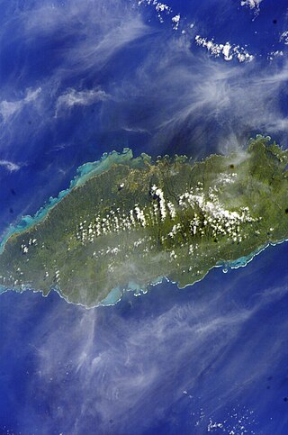
Savaiʻi is the largest and highest island both in Samoa and in the Samoan Islands chain. The island is also the sixth largest in Polynesia, behind the three main islands of New Zealand and the Hawaiian Islands of Hawaii and Maui. While it is larger than the second main island, Upolu, it is significantly less populated.
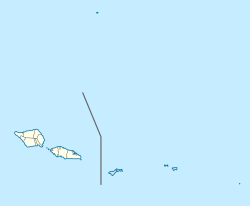
Samoa is divided into eleven itūmālō, which were established well before the arrival of Europeans. Each district has its own constitutional foundation (faavae), rooted in the traditional order of title precedence as outlined in its faalupega.
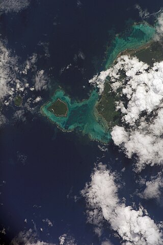
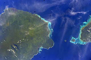
Aiga-i-le-Tai is a district of Samoa which includes the small islands of Manono, Apolima and tiny uninhabited Nu'ulopa lying in the Apolima Strait between the country's two main islands of Upolu and Savai'i.

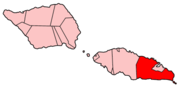
Ātua is an ancient political district of Samoa, consisting of most of the eastern section of Upolu and the island Tutuila. Within Samoa's traditional polity, Ātua is ruled by the Tui Ātua together with the group of six senior orators of Lufilufi and 13 senior matai from throughout Ātua, comprising the Fale Ātua. The fono (meeting) of Atua's rulers takes place in Lufilufi on the great malae of Lalogafu'afu'a.
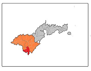
Tuamāsaga is a district of Samoa, with a population of 95,907. This makes it the most populous district in Samoa. The geographic area of Tuamasaga covers the central part of Upolu island, and includes the capital, Apia.
Faʻasaleleaga is a district of Samoa situated on the eastern side of Savaiʻi island. It has a population of 13,566.

Aunuʻu is a small volcanic island off the southeastern shore of Tutuila in Saʻole County, American Samoa. It has a land area of 374.83 acres, and a 2010 census population of 436 persons. Politically, it is a part of the Eastern District, one of the two primary political divisions of American Samoa.
Aūa is a village on Tutuila Island in American Samoa. It is located along American Samoa Highway 001, and is the southern terminus of American Samoa Highway 006. Aūa is located at the foothills of Mount Peiva on the eastern shore of Pago Pago Bay. The hamlet of Leloaloa is also a part of Aūa.
Mālietoa is a state dynasty and one of the four paramount chiefly titles of Samoa. It is the titular head of one of the two great royal families of Samoa: Sā Malietoa. Literally translated as "great warrior", the title's origin comes from the final words of the Tongan warriors as they were fleeing on the beach to their boats, "Malie To`a, Malo e tau...".

Neiafu is a village on the island of Savai'i in Samoa. It is in the Alataua Sisifo electoral district and located at the south west corner of the island. The population of Neiafu Uta is 601 and Neiafu Tai is 307.
Auala is a small village on the northwest coast of Savai'i island in Samoa. The village is in the electoral constituency of Vaisigano East which forms part of the larger political district of Vaisigano. The village's population was 507 in 2016, a decrease from 573 in 2011.

Falefā is located on the north eastern coast of Upolu island in Samoa. It was the ancient capital during the ‘Malo’ (‘government’) of Tupu Tafa'ifa (King) Fonoti after defeating his nephew Toleafoa and sister Samalaulu for control of Samoa. King Fonoti chose to rule from his new seat in Falefa, an honour remembered in its faalupega to this day.
Samoan literature can be divided into oral and written literatures, in the Samoan language and in English or English translation, and is from the Samoa Islands of independent Samoa and American Samoa, and Samoan writers in diaspora. Samoan as a written language emerged after 1830 when Tahitian and English missionaries from the London Missionary Society, working with Samoan chiefly orators, developed a Latin script–based Samoan written language. Before this, there were logologo and tatau but no phonetic written form.
Malie is a village on the island of Upolu in Samoa. It is located on the north coast in the Electoral Constituency of Sagaga Le Usoga which forms part of the larger political district of Tuamasaga. The village has been a traditional headquarters for the Malietoa, one of the four paramount families and royal titles of Samoa. The village has a population of 2247.
Ama is a title originating c. 1400 AD, and bestowed upon the paramount chief and commander in war of the district of Safata, situated south of the island of Upolu, within the country of Samoa. It is a hereditary title. The title originated from Lotofaga, a village within the Safata district. Lotofaga is a village that sits in the middle of the Safata Bay. The village has been described as the following: 'Here the surf is sometimes so wild that one cannot sleep because of the roar; therefore it is called Galutatu'. It is also known as Le-Faga-o-Alii, translated in Samoan as 'The Bay of Chiefs'. This is in reference to the Ama that resides there. Lotofaga is traditionally known to be a village of refuge for those in need as well as a place to observe and learn of Samoan chief customs and etiquette.

Samoa competed at the 2015 Pacific Games in Port Moresby, Papua New Guinea from 4 to 18 July 2015. Samoa listed 405 competitors as of 4 July 2015. Eight competitors were qualified in two sports.
Vailoatai is a village in southwestern Tutuila, the main island of American Samoa. It is located on the eastern end of Leone Bay. The village is known for its beautiful malae, nested along the island's rugged southern coast and lined by the fale tali mālō of its village chiefs.
Tuālā-tai County is one of the five counties that make up the Western District of American Samoa.
Le Mamea Makalau also known as Le Mamea MK was a Samoan high chief, judge, civil servant, diplomat, and author. Le Mamea Makalau held the high chief title of Le Mamea from Matatutu Lefaga. He held senior positions in the (precolonial) Samoan Kingdom where he served as Minister of the Interior in the government of King Malietoa Laupepa. He travelled to Washington DC as Samoa's Envoy Extraordinary and Plenipotentiary to negotiate a treaty with the United States to make Samoa a US protectorate.