Aleipata Islands

Last updated
Aleipata Islands
Aleipata.jpg
Aleipata islands east of Upolu island (NASA)
Aleipata Islands
Geography
Coordinates 14°04′20″S171°24′40″W / 14.07222°S 171.41111°W / -14.07222; -171.41111
Area1.7 km2 (0.66 sq mi)
Highest elevation180 m (590 ft)
Administration
Flag of Samoa.svg  Samoa
Demographics
PopulationUninhabited

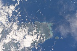
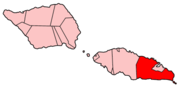
The Aleipata Islands are a group of four uninhabited islands off the eastern end of Upolu Island, Samoa, in central South Pacific Ocean. The islands are eroded volcanic tuff rings, and consist of a small northern pair on Upolu's barrier reef, and a larger southern pair outside it. [1] Collectively the islands have an area of about 1.7 km2 (0.66 sq mi). [2] Administratively, the islands are part of the Atua district. The islands are important for Samoa's biodiversity and are protected by the Aleipata Marine Protected Area. [3]

Contents

Geography

From north to south, the islands consist of:

Namua and Fanuatapu lie at the outer edge of the fringing reef of Upolu, at a distance of 0.7 km and 2.5 km, respectively, from Upolu Island itself. Nuʻutele and Nuʻulua are 4 to 6 km further south, outside the fringing reef, and lie 1.4 km 3.5 km off Cape Tapaga, which is the southeastern headland of Upolu. Only Namua is open for visitors, who can enjoy the Namua Island Resort and the beaches. Fanuatapu, being the easternmost island, has a lighthouse.

Environment

The islands are uninhabited and relatively undisturbed, and provide an important refuge for native plant and animal species. [2] The northern islands are mostly bare rock and coastal forest, while the larger southern group are mostly covered by coastal and lowland forest. [2] The islands are home to the largest population of Tongan ground doves in Samoa, as well as Coconut crabs, and provides a nesting place for critically-endangered Hawksbill sea turtles, [4] and birds including the Samoan flycatcher and Manumean. [1]

In 2009 an attempt was made to eradicate the introduced Polynesian rat from the southern islands using air-dropped Brodifacoum to provide a pest-free refuge. [5] The attempt was unsuccessful, with rats being detected again in 2011. [4]

See also

Related Research Articles

<span class="mw-page-title-main">Kingman Reef</span> Reef and unincorporated U.S. territory in the Pacific Ocean

Kingman Reef is a largely submerged, uninhabited, triangle-shaped reef, geologically an atoll, 9.0 nmi (20 km) east-west and 4.5 nmi (8 km) north-south, in the North Pacific Ocean, roughly halfway between the Hawaiian Islands and American Samoa. It has an area of 3 hectares and is a unincorporated territory of the United States in Oceania. The reef is administered by the United States Fish and Wildlife Service as the Kingman Reef National Wildlife Refuge. It was claimed by the US in 1859, and later used briefly as stopover for commercial Pacific flying boat routes in the 1930s going to New Zealand; however, the route was changed with a different stopover. It was administered by the Navy from 1934 to 2000, and thereafter the Fish and Wildlife service. It has since become a marine protected area. In the 19th century it was noted as maritime hazard, earning the name Hazard Rocks, and is known to have been hit once in 1876. In the 21st century it has been noted for is marine biodiversity and remote nature. There are hundreds of species of fish and coral on and around the reef.

<span class="mw-page-title-main">Samoa</span> Polynesian island country

Samoa, officially the Independent State of Samoa and until 1997 known as Western Samoa, is a Polynesian island country consisting of two main islands ; two smaller, inhabited islands ; and several smaller, uninhabited islands, including the Aleipata Islands. Samoa is located 64 km (40 mi) west of American Samoa, 889 km (552 mi) northeast of Tonga, 1,152 km (716 mi) northeast of Fiji, 483 km (300 mi) east of Wallis and Futuna, 1,151 km (715 mi) southeast of Tuvalu, 519 km (322 mi) south of Tokelau, 4,190 km (2,600 mi) southwest of Hawaii, and 610 km (380 mi) northwest of Niue. The capital and largest city is Apia. The Lapita people discovered and settled the Samoan Islands around 3,500 years ago. They developed a Samoan language and Samoan cultural identity.

<span class="mw-page-title-main">Geography of Samoa</span>

The Samoan archipelago is a chain of 16 islands and numerous seamounts covering 3,123 km2 (1,206 sq mi) in the central South Pacific, south of the equator, about halfway between Hawaii and New Zealand, forming part of Polynesia and of the wider region of Oceania. The islands are Savaiʻi, Upolu, Tutuila, ’Uvea, Taʻū, Ofu, Olosega, Apolima, Manono, Nuʻutele, Niulakita, Nuʻulua, Namua, Fanuatapu, Rose Atoll, Nu'ulopa, as well as the submerged Vailuluʻu, Pasco banks, and Alexa Bank.

<span class="mw-page-title-main">Geography of Seychelles</span> Geography of the Seychelles islands

Seychelles is a small island country east of the African continent located in the Sea of Zanj due north of Madagascar, with Antsiranana as its nearest foreign city. Seychelles lies between approximately 4ºS and 10ºS and 46ºE and 54ºE. The nation is an archipelago of 155 tropical islands, some granite and some coral. the majority of which are small and uninhabited. The landmass is only 452 km2 (175 sq mi), but the islands are spread wide over an exclusive economic zone of 1,336,559 km2 (516,048 sq mi). About 90 percent of the population of 100,000 live on Mahé, 9 percent on Praslin and La Digue. Around a third of the land area is the island of Mahé and a further third the atoll of Aldabra.

<span class="mw-page-title-main">Upolu</span> Island in Samoa

Upolu is an island in Samoa, formed by a massive basaltic shield volcano which rises from the seafloor of the western Pacific Ocean. The island is 75 kilometres long and 1,125 square kilometres in area, making it the second largest of the Samoan Islands by area. With approximately 145,000 inhabitants, it is by far the most populous of the Samoan Islands. Upolu is situated to the southeast of Savai'i, the "big island". Apia, the capital, is in the middle of the north coast, and Faleolo International Airport at the western end of the island. The island has not had any historically recorded eruptions, although there is evidence of three lava flows, dating back only to between a few hundred and a few thousand years ago.

<span class="mw-page-title-main">Samoan Islands</span> Archipelago in the South Pacific Ocean

The Samoan Islands are an archipelago covering 3,030 km2 (1,170 sq mi) in the central South Pacific, forming part of Polynesia and of the wider region of Oceania. Administratively, the archipelago comprises all of the Independent State of Samoa and most of American Samoa. The land masses of the two Samoan jurisdictions are separated by 64 km (40 mi) of ocean at their closest points.

<span class="mw-page-title-main">Savaiʻi</span> Island in the Samoan Islands chain

Savaiʻi is the largest and highest island both in Samoa and in the Samoan Islands chain. The island is also the sixth largest in Polynesia, behind the three main islands of New Zealand and the Hawaiian Islands of Hawaii and Maui. While it is larger than the second main island, Upolu, it is significantly less populated.

<span class="mw-page-title-main">Kermadec Islands</span> Subtropical island arc in the South Pacific Ocean

The Kermadec Islands are a subtropical island arc in the South Pacific Ocean 800–1,000 km (500–620 mi) northeast of New Zealand's North Island, and a similar distance southwest of Tonga. The islands are part of New Zealand. They are 33.6 km2 (13.0 sq mi) in total area and uninhabited, except for the permanently staffed Raoul Island Station, the northernmost outpost of New Zealand.

<span class="mw-page-title-main">Apolima</span> Island in Samoa

Apolima is the smallest of the four inhabited islands of Samoa, in central South Pacific Ocean. It lies in the Apolima Strait, between the country's two largest islands: Upolu to the east, and Savai'i to the west.

<span class="mw-page-title-main">Tutuila</span> Largest island in American Samoa

Tutuila is the largest and most populous island of American Samoa and is part of the archipelago of the Samoan Islands. It is the third largest island in the Samoan Islands chain of the Central Pacific. It is located roughly 4,000 kilometers (2,500 mi) northeast of Brisbane, Australia and lies over 1,200 kilometers (750 mi) to the northeast of Fiji. It contains a large, natural harbor, Pago Pago Harbor, where Pago Pago, the capital of American Samoa, is situated. Pago Pago International Airport is also located on Tutuila. The island's land expanse is about 68% of the total land area of American Samoa. With 56,000 inhabitants, it is also home to 95% of the population of American Samoa. The island has six terrestrial and three marine ecosystems.

<span class="mw-page-title-main">Rose Atoll</span> Atoll in American Samoa

Rose Atoll, sometimes called Rose Island or Motu O Manu by people of the Manu'a Islands, is an oceanic atoll within the U.S. territory of American Samoa. An uninhabited wildlife refuge, it is the southernmost point belonging to the United States. The land area is just 0.05 km2 at high tide. The total area of the atoll, including lagoon and reef flat amounts to 6.33 km2. Just west of the northernmost point is a channel into the lagoon, about 80 m wide. There are two islets on the northeastern rim of the reef, larger Rose Island in the east and the non-vegetated Sand Island in the north. The Rose Atoll Marine National Monument that lies on the two outstanding islands of the Atoll is managed cooperatively between the U.S. Fish and Wildlife Service and the government of American Samoa.

<span class="mw-page-title-main">Nuʻutele</span> Island in Atua District, Samoa

Nuʻutele is an island that consists of a volcanic tuff ring. It lies 1.3 km off the eastern end of Upolu island, Samoa, in central South Pacific Ocean. It is the largest of the four Aleipata Islands, with an area of 1.15 km2 (0.44 sq mi).

<span class="mw-page-title-main">Pacific Remote Islands Marine National Monument</span> Group of unorganized United States Pacific Island territories

The Pacific Remote Islands Marine National Monument is a group of unorganized, mostly unincorporated United States Pacific Island territories managed by the United States Fish and Wildlife Service of the United States Department of the Interior and the National Oceanic and Atmospheric Administration (NOAA) of the United States Department of Commerce. These remote refuges are "the most widespread collection of marine- and terrestrial-life protected areas on the planet under a single country's jurisdiction". They protect many endemic species including corals, fish, shellfish, marine mammals, seabirds, water birds, land birds, insects, and vegetation not found elsewhere.

<span class="mw-page-title-main">Lalomanu</span> Village in Atua, Samoa

Lalomanu is a village on the east coast of Upolu island in Samoa.The village is part of the electoral constituency Aleipata Itupa i Luga which is within the larger political district of Atua. It has a population of 712.

<span class="mw-page-title-main">Mao (bird)</span> Species of birds

The mao or ma'oma'o is a passerine bird belonging to the genus Gymnomyza in the honeyeater family Meliphagidae. It is an endangered species and is endemic to the Samoan Islands.

The Oregon Coast National Wildlife Refuge Complex consists of six National Wildlife Refuges along the Oregon Coast. It provides wilderness protection to thousands of small islands, rocks, reefs, headlands, marshes, and bays totaling 371 acres spanning 320 miles (515 km) of Oregon's coastline. The areas are all managed by the United States Fish and Wildlife Service.

<span class="mw-page-title-main">San Juan Islands National Wildlife Refuge</span> Wildlife refuge in Washington, US

The San Juan Islands National Wildlife Refuge is in the San Juan Islands of the Salish Sea, north of Puget Sound, in the State of Washington. Created in 1976, it comprises 83 small, uninhabited islands, scattered throughout the San Juans, with a combined area of approximately 454 acres (1.84 km2). The Refuge is managed by the U.S. Fish and Wildlife Service as one of six in the Washington Maritime National Wildlife Refuge Complex.

<span class="mw-page-title-main">Nuʻulua</span> Island in Atua District, Samoa

Nuʻulua is an island in Samoa. It is located in the Aleipata Islands, somewhat more than 1.3 km from the eastern end of Upolu.

<span class="mw-page-title-main">Coral reefs of the Solomon Islands</span>

The Coral reefs of the Solomon Islands consists of six major islands and over 986 smaller islands, in Oceania, to the east of Papua New Guinea and northwest of Vanuatu. The Solomon Islands lie between latitudes 5° and 13°S, and longitudes 155° and 169°E. The distance between the westernmost and easternmost islands is about 1,500 km (930 mi). The Santa Cruz Islands are situated north of Vanuatu and are especially isolated at more than 200 km (120 mi) from the other islands. The Solomon Islands has the 22nd largest Exclusive Economic Zone of 1,589,477 km2 (613,701 sq mi) of the Pacific Ocean.

References

  1. 1 2 "Aleipata Islands". OceanDots.com. Archived from the original on 2010-12-23. Retrieved 2009-03-14.
  2. 1 2 3 Whistler, W. Arthur (1983). "Vegetation and Flora of the Aleipata Islands, Western Samoa" (PDF). Pacific Science. 37 (3): 227–249. Retrieved 17 August 2021.
  3. "Community Integrated Management Plan: Aleipata-Itupa I Luga - Upolu" (PDF). Ministry of Natural Resources and Environment. 2018. p. 12. Retrieved 17 August 2021.
  4. 1 2 "Restoration of Nu'utele and Nu'ulua islands (Aleipata group), Samoa, through the management of introduced rats and ants" (PDF). Conservation International. 2013. Retrieved 17 August 2021.
  5. Parrish, Richard; Sherley, Greg H. (2012). "Birds of the Aleipata Islands, Samoa" (PDF). Notornis. 59: 153–162. Retrieved 17 August 2021.