
Guinea is a country on the coast of West Africa and is bordered by Guinea-Bissau, Senegal, Mali, Ivory Coast, Liberia, and Sierra Leone.

Sierra Leone, officially the Republic of Sierra Leone, informally Salone, is a country on the southwest coast of West Africa. It is bordered by Liberia to the southeast and Guinea to the northeast. Sierra Leone has a tropical climate with a diverse environment ranging from savanna to rainforests, a total area of 71,740 km2 (27,699 sq mi) and a population of 7,092,113 as of the 2015 census. The capital and largest city is Freetown. The country is divided into five administrative regions which are subdivided into sixteen districts. Sierra Leone is a constitutional republic with a unicameral parliament and a directly elected president. Sierra Leone is a Muslim majority country at approximately 78%, though with a politically influential Christian minority at about 21%. Muslims and Christians interact very well together and religious violence is extremely rare in the country. All the major Muslim and Christian holidays are officially national holidays in the country.

Sierra Leone is located on the west coast of Africa, between the 7th and 10th parallels north of the equator. Sierra Leone is bordered by Guinea to the north and northeast, Liberia to the south and southeast, and the Atlantic Ocean to the west.

Pepel is a coastal town in the Port Loko District in the Northern Province of Sierra Leone.

Makeni is the largest city in the Northern Province of Sierra Leone. The city is the capital of Bombali District, and is the economic center of the Northern Province. Makeni is the fifth largest city in Sierra Leone by population. The city of Makeni had a population of 80,840 in the 2004 census and a 2013 estimate of 112,428. Makeni lies approximately 110 miles east of Freetown. Makeni is home to the University of Makeni, the largest private university in Sierra Leone.
Guinée forestière is a forested mountainous region in southeastern Guinea, extending into northeastern Sierra Leone. It is one of four natural regions into which Guinea is divided and covers 23% of the country. It includes all of the Nzérékoré administrative region, and shares a border with Sierra Leone and Liberia. Its rocky topology contains several mountain ranges and has an average elevation of 460m. Forested Guinea contains important areas of biological diversity such as the UNESCO World Heritage site Mount Nimba Strict Nature Reserve and biosphere reserve Ziama Massif. The Guéckédou prefectures also recorded the initial case of the 2014 Ebola outbreak in Meliandou, a rural village. The virus subsequently spread to urban areas and neighbouring countries Sierra Leone and Liberia.

The Southern Province is one of the four provinces of Sierra Leone. It covers an area of 19,694 km² and has a population of 1,438,572. It consists of four districts. Its capital and administrative center is Bo, which is also the second largest and second most populated city in Sierra Leone after the nation's capital Freetown. The population of the southern province is largely from the Mende ethnic group.

The Western Area or Freetown Peninsula is one of five principal divisions of Sierra Leone. It comprises the oldest city and national capital Freetown and its surrounding towns and countryside. It covers an area of 557 km2 and has a population of 1,447,271. The Western Area is located mostly around the peninsula and is divided into two districts: the Western Area Rural and the Western Area Urban.

Kailahun is the capital of Kailahun District in the Eastern Province of Sierra Leone. Kailahun is a major business and commercial center of Kailahun District. The population was 13,108 in the 2004 census, a 2006 estimate of 18,411 and a current estimate of about 30,411. Kailahun lies in the far east of Sierra Leone, approximately 200 miles east of Freetown ; and about 51 miles north east of Kenema.

The Eastern Province is one of the four provinces of Sierra Leone. It covers an area of 15,553 km² and has a population of 1,641,012. Its capital and administrative centre is Kenema. Eastern Province, the centre of the country's diamond mining industry, is very mountainous and has two ranges, the Gola Hills and the Loma Mountains.

Siaka Stevens Stadium commonly known informally as National Stadium, is the national stadium of Sierra Leone, located in the capital city of Freetown. It is used mostly for football matches and it also has athletics facilities. It is the largest and main stadium in Sierra Leone and has a 45,000 capacity. The stadium serves as the exclusive home of the Sierra Leone national football team, known as the Leone Stars.
Tombodu is a relatively small provincial town - the third largest town in Kono District in the Eastern Province, Sierra Leone. The town had a population of less than 3000 in the 2004 census. Tombodu was RUF stronghold during the Sierra Leone civil war. The majority of the residents in the town are from the Kono ethnic group. The town is the birthplace of Johnny Paul Koroma, the former leader of the Armed Forces Revolutionary Council (AFRC) military junta of Sierra Leone.
Kouankan is a town and sub-prefecture in the Macenta Prefecture in the Nzérékoré Region of south-eastern Guinea

The 2009 Sierra Leone ferry accident occurred on 8 September 2009 off the coast of Sierra Leone, when a wooden Teh Teh ferry travelling from Shenge village to Tombo sank during a storm. At least 90 people to date have been confirmed dead, and over 100 others have been listed as "missing". So far, only 39 survivors have been rescued. Several of the passengers were children who had been on holiday, though the official passenger manifest did not include them. An attempted rescue operation ended on 11 September. The sinking is the worst such accident in Sierra Leone since 2002, when a boatful of refugees capsized. The Xinhua News Agency in China has likened the disaster to other major marine accidents in recent years.

Guéckédou or Guékédou is a town in southern Guinea near the Sierra Leone and Liberian borders. It had a population of 79,140 in 1996 (census) but has grown massively since the civil wars and, as of 2008, it is estimated to be 221,715. It was a centre of fighting during the Second Liberian Civil War and the Sierra Leone Civil War in 2000 and 2001.

Heineken and United African Company (UAC) began construction of the Sierra Leone Brewery Limited in October 1961 in Wellington Industrial Estate in Freetown and the first brew was mashed-in on 23 November 1962. The first brand to be brewed was Star Lager.
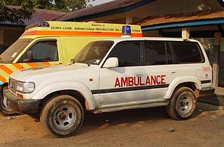
Healthcare in Sierra Leone is generally charged for and is provided by a mixture of government, private and non-governmental organizations (NGOs). There are over 100 NGOs operating in the health care sector in Sierra Leone. The Ministry of Health and Sanitation is responsible for organizing health care and after the end of the civil war the ministry changed to a decentralized structure of health provision to try to increase its coverage.

An Ebola virus epidemic in Sierra Leone occurred in 2014, along with the neighbouring countries of Guinea and Liberia. On March 18, 2014 Guinean health officials announce the outbreak of a mysterious hemorrhagic fever "which strikes like lightning." It was identified as Ebola virus disease and spread to Sierra Leone by May 2014. The disease is thought to have originated when a child in a bat-hunting family contracted the disease in Guinea in December 2013.
Charlotte is a mountainous village in the Rural District in the Western Area of Sierra Leone. Charlotte is located about twenty miles outside Freetown, Sierra Leone's capital. Charlotte, is commonly known as Charlotte Village, and is in close proximity to the towns of Regent, and Leicester. The main economic activity in Charlotte is farming.

Panguma is a village in eastern Sierra Leone, with a population of 7965. The village had previously been the capital of Mende chief Nyagua during the 19th century.
