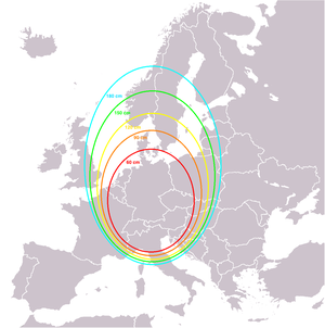
The footprint of a communications satellite is the ground area that its transponders offer coverage, and determines the satellite dish diameter required to receive each transponder's signal. There is usually a different map for each transponder (or group of transponders), as each may be aimed to cover different areas. [1] [2]
Contents
Footprint maps usually show either the estimated minimum satellite dish diameter required or the signal strength in each area measured in dBW. [1]