Related Research Articles
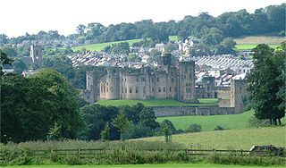
Alnwick is a market town in Northumberland, England, of which it is the traditional county town. The population at the 2011 Census was 8,116.

Hulne Priory, Hulne Friary or Hulne Abbey was a friary founded in 1240 by the Carmelites or 'Whitefriars'. It is said that the Northumberland site, quite close to Alnwick, was chosen for some slight resemblance to Mount Carmel where the order originated. Substantial ruins survive, watched over by the stone figures of friars carved in the 18th century. It is a sign of the unrest felt in this area so near to the border with Scotland that the priory had a surrounding wall and in the 15th century a pele tower was erected. Changes were made at the Dissolution of the Monasteries when the Percy family took control.
Berwick-upon-Tweed was a local government district and borough in Northumberland in the north-east of England, on the border with Scotland. The district had a resident population of 25,949 according to the 2001 census, which also notes that it is the most ethnically homogeneous in the country, with 99.6% of the population recording themselves in the 2001 census as White. It was also the least populated district in England with borough status, and the third-least densely populated local government district.

Nesbit is a hamlet and former civil parish, now in the parish of Doddington, Northumberland, England. It was once the site of a medieval village. In maps published during the 17th to 19th centuries, the name of the settlement was variously spelled Nesbet, Nesbitt or Nesbit. In 1951 the parish had a population of 143.

Berwick-upon-Tweed is a parliamentary constituency in Northumberland represented in the House of Commons of the UK Parliament since 2015 by Anne-Marie Trevelyan, a Conservative.

The Royal Border Bridge spans the River Tweed between Berwick-upon-Tweed and Tweedmouth in Northumberland, England. It is a Grade I listed railway viaduct built between 1847 and 1850, when it was opened by Queen Victoria. It was designed by Robert Stephenson. It was built for the York, Newcastle and Berwick Railway and is still in regular use today, as part of the East Coast Main Line. Despite its name, the bridge does not in fact span the border between England and Scotland, which is approximately three miles further north.
The Pennine Cycleway is a Sustrans-sponsored route in the Pennines range in northern England, an area often called the "backbone of England". The route passes through the counties of Derbyshire, West Yorkshire, Lancashire, North Yorkshire, Cumbria and Northumberland. It is part of the National Cycle Network (NCN). Sustrans founder John Grimshaw calls it 'the best National Cycle Network route of the lot'.

Heatherslaw Mill is a water mill situated on the Ford and Etal Estate, 7 miles north of the town of Wooler in the English county of Northumberland.
The Battle of Piperdean was an engagement in the Scottish Borders, fought on 10 September 1435 between the Kingdom of Scotland and the Kingdom of England.

Ros Hill, also known as Ros Castle due to the 3,000-year-old Iron Age hill fort on its summit, is a hill in the county of Northumberland in northern England. It is the highest point of a low range of hills stretching from Alnwick to Berwick-upon-Tweed — the Chillingham Hills. Other tops of the Chillingham Hills include Titlington Pike, Dod Law and Doddington Northmoor. However, Ros Hill is significantly higher than these and towers over the surrounding landscape with easily enough relative height to make it a "Marilyn".
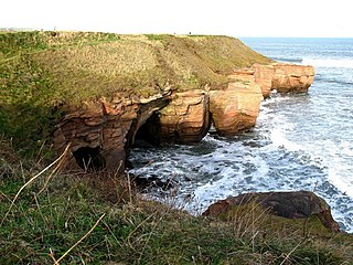
The Northumberland Coast is a designated Area of Outstanding Natural Beauty (AONB) covering 40 miles (64 km) of coastline from Berwick-Upon-Tweed to the River Coquet estuary in the Northeast of England. Features include: Alnmouth, Bamburgh, Beadnell, Budle Bay, Cocklawburn Beach, Craster, Dunstanburgh Castle, the Farne Islands, Lindisfarne and Seahouses. It lies within the natural region of the North Northumberland Coastal Plain.

The Lackawanna and Bloomsburg Railroad (LBR) was an 80-mile (130 km) long 19th century railroad that ran between Scranton and Northumberland in Pennsylvania in the United States. Incorporated in 1852, the railroad began operation in 1856 and was taken over by the Delaware, Lackawanna and Western Railroad in 1873. The western end of the line, from Northumberland to Beach Haven, is still in operation as the shortline North Shore Railroad.

The A6105 road is an A road in the Scottish Borders, Scotland and Northumberland, England. It runs from the village of Earlston to Berwick on Tweed going via Greenlaw and Duns through the Scottish Borders and entering into England, just east of the village of Foulden. The road is 33 miles (53 km) long. The route is single carriageway for its entire length.
Northumberland College is a further education college based in Ashington, Northumberland, England. The present site opened in 1957, and became the County Technical College in 1961, transformed again in 1987, becoming the Northumberland College of Arts and Technology, and finally settled upon its current status in 1995.
Berwick Power Station was a small coal-fired power station situated at the mouth of the River Tweed, at Berwick-upon-Tweed in Northumberland, North East England.

Rothbury was a railway station in Northumberland, England at the end of the single-track Rothbury Branch that served the town of Rothbury. Rothbury was the terminus of the line with a turntable at the end of the track.

Brinkburn was a weatherboard- and corrugated-iron-built railway station in Northumberland on the Rothbury Branch built to serve the Healy Coate Colliery to which it was linked by a two-mile aerial ropeway.
Ford Moss is a Site of Special Scientific Interest (SSSI), containing a Scheduled Ancient Monument, located 12 miles (19 km) south-west of Berwick-upon-Tweed, Northumberland, England. The site is managed by the Northumberland Wildlife Trust and gained its SSSI status in 1968, and in 2005 it was designated a Special Area of Conservation.
The Berwickshire Coastal Path is a walking route some 48 kilometres (30 mi) long. It follows the eastern coastline of Scotland from Cockburnspath in the Scottish Borders to Berwick upon Tweed, just over the border in England. At Cockburnspath the path links with the Southern Upland Way and the John Muir Way.
References
- ↑ "History of Ford Forge, in Berwick upon Tweed and Northumberland | Map and description". www.visionofbritain.org.uk. Retrieved 24 December 2016.