Ford crossing, West Toodyay

Last updated

Coordinates: 31°31′46″S116°25′09″E / 31.5294°S 116.4193°E / -31.5294; 116.4193

Geographic coordinate system Coordinate system

A geographic coordinate system is a coordinate system that enables every location on Earth to be specified by a set of numbers, letters or symbols. The coordinates are often chosen such that one of the numbers represents a vertical position and two or three of the numbers represent a horizontal position; alternatively, a geographic position may be expressed in a combined three-dimensional Cartesian vector. A common choice of coordinates is latitude, longitude and elevation. To specify a location on a plane requires a map projection.

Natural ford crossing, West Toodyay, 2016 Ford crossing of Avon River, West Toodyay, Western Australia 2015.jpg
Natural ford crossing, West Toodyay, 2016
Northern approach from near the site of the Highland Laddie Right bank approach to ford crossing of Avon River, West Toodyay, Western Australia 2015.jpg
Northern approach from near the site of the Highland Laddie

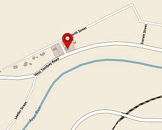
The ford crossing is a natural feature of the Avon River in West Toodyay, Western Australia. It was used by the early settlers in the area to cross the river before the construction of the West Toodyay Bridge.

Avon River (Western Australia) river in Western Australia, Australia

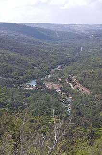
The Avon River is a river in Western Australia. A tributary of the Swan River, the Avon flows 240 kilometres (150 mi) from source to mouth, with a catchment area of 125,000 square kilometres (48,000 sq mi).

West Toodyay locality in Western Australia

West Toodyay was the original location of the town of Toodyay, Western Australia. It is situated in the Toodyay valley, 85 kilometres (53 mi) north east of Perth. The Toodyay valley, discovered by Ensign Robert Dale in 1831, was opened up for settlement in 1836. The original site for the town of Toodyay was determined in 1836 and its boundaries were finalized 1838. The first survey of the town was carried out in 1849. After several serious floods, the decision was made to move the town of Toodyay to higher ground. In 1860, the new town of Newcastle was established 3 miles (4.8 km) further upstream. Newcastle was renamed in 1910 to Toodyay, and the original site became known as West Toodyay.

West Toodyay Bridge

The West Toodyay Bridge crosses the Avon River in West Toodyay, Western Australia.

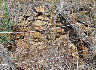
For many years the whereabouts of the ford remained a mystery. It is not marked on any early survey map. In addition, the building of the West Toodyay Bridge in 1902 negated its use and details of its existence were lost. However, research carried out and published in 2010 revealed that the ford crossing was, and still is, a natural feature of the Avon River. A wide rocky shelf spans the river immediately upstream from the West Toodyay Bridge. It would have facilitated an easy crossing. In addition, the approaches on either side are relatively protected from erosion during times of flood. [1]

Ford (crossing) crossing in a river

A ford is a shallow place with good footing where a river or stream may be crossed by wading, or inside a vehicle getting its wheels wet. A ford may occur naturally or be constructed. Fords may be impassable during high water. A low water crossing is a low bridge that allows crossing over a river or stream when water is low but may be covered by deep water when the river is high.

It is highly probable that the rocky ford crossing was part of a long established trail used by the local indigenous Ballardong Noongar people [2] as they travelled up and down the Toodyay valley. [1]

Ballardong Western Australian indigenous language dialect

Ballardong are an indigenous Noongar people of the south western area of Western Australia.

Noongar an Indigenous Australian people who live in the south-west corner of Western Australia, from Geraldton on the west coast to Esperance on the south coast

The Noongar are a constellation of peoples of Indigenous Australian descent who live in the south-west corner of Western Australia, from Geraldton on the west coast to Esperance on the south coast. Noongar country is now understood as referring to the land occupied by 14 different groups: Amangu, Ballardong, Yued, Kaneang, Koreng, Mineng, Njakinjaki, Njunga, Pibelmen, Pindjarup, Wardandi, Whadjuk, Wiilman and Wudjari.

Toodyay valley is an older term for the section of the Avon River valley in Western Australia, where the town of Toodyay, and its original site are located.

The ford proved ideal for the passage of horse, cart and wagon across the Avon River. If, however, the river was in flood, any crossing of the river would have been too dangerous to attempt. Nevertheless, unlike other purposely built fords, there appear to have been no reports of damage to the ford, even in times of severe flooding, nor of any repairs having been carried out to its approaches.

On the upstream side of the ford lay a long pool. The pool was fed by a permanently running spring that entered the river bed from the north side of the Avon River. Thus, throughout the heat of summer, the pool was ever present. The Military Barracks also stood upstream from the ford crossing on the left hand bank of the river. [1] The ford crossing proved to be of paramount importance to the early inhabitants of the town of Toodyay as well as those in the valley beyond.

Related Research Articles

Toodyay, Western Australia Town in Western Australia

Toodyay, known as Newcastle between 1860 and 1910, is a town on the Avon River in the Wheatbelt region of Western Australia, 85 kilometres (53 mi) north-east of Perth on Ballardong Nyoongar land. The first European settlement occurred in the area in 1836. After flooding in the 1850s, the townsite was moved to its current location in the 1860s. It is connected by railway and road to Perth. During the 1860s, it was home to bushranger Moondyne Joe.

Naming of Toodyay, Western Australia

The town of Toodyay, Western Australia was not always known by that name. Initially Toodyay was located in what is now West Toodyay before repeated flooding caused the town centre to migrate to the area around the Newcastle convict depot creating the town of Newcastle. After approximately 50 years of confusion the name of Newcastle was changed to Toodyay and the original Toodyay became known as West Toodyay.

Toodyay Court House building in Toodyay, Western Australia

The former Toodyay Court House in Toodyay, Western Australia has been used as municipal offices for Toodyay since the 1950s.

Francis Kirk was one of a number of Enrolled Pensioner Guards (EPGs) who came to the Swan River Colony between 1850 and 1868, to guard and oversee the work of the prisoners transported to Western Australia.

Toodyay Barracks

The Toodyay Barracks and its stables, erected in 1842, were the first buildings constructed in the townsite of Toodyay, Western Australia. The Barracks were also the first government buildings within the Toodyay district. Situated on the left bank of the Avon River and a little upstream from the ford, the Barracks overlooked a long pool, which soon became known as the Barracks Pool. In the early 1840s, Toodyay Resident Magistrate John Scully had requested military protection as a means of controlling a problem with the local indigenous people. Governor John Hutt agreed at the time to temporarily station a mounted native policeman to keep order.

The Highland Laddie, Toodyay

The Highland Laddie was an inn in West Toodyay. The business was initially established in 1850 as the Bonnie Laddie, and also traded as the Gum Tree Tavern.

The Queens Head, Toodyay hotel in West Toodyay, Western Australia

The Queen's Head was a hotel in West Toodyay in Western Australia in the latter half of the 19th century.

Toodyay Convict Hiring Depot (1851)

In 1851, the Toodyay Convict Hiring Depot was set up in the original township of Toodyay, now called West Toodyay. Temporary accommodation for the Enrolled Pensioner Guards was also constructed and surveys were carried out to enable more permanent accommodation to be built close by. The Enrolled Pensioner Guards were men who had either completed their duty of service or who had sustained injury while on active service. They had then volunteered as guards on the ships transporting convicts to Western Australia. Once the men were released from permanent duty, other duties of a peace keeping or military nature were expected of them. Many of these men became warders in charge of convicts.

Toodyay Gaol former prison in Western Australia

Toodyay Gaol stood on lot R66, close to the first Convict Hiring Depot, in the original townsite of Toodyay, now known as West Toodyay, in Western Australia. Although generally referred to as a gaol, it was technically a lock-up, holding prisoners only until they were brought before the resident magistrate.

Reserve and well, Toodyay water reserve and well in Western Australia

An area in West Toodyay, Western Australia, around 31.523°S 116.4263°E, was gazetted as a Class C Reserve, for water and public utility purposes from 1898 to 1992. A stone-lined well at 31.52281°S 116.42579°E, positioned on what was originally lot R76, exists to this today. It is, however, no longer in use. The well is close to the boundary with what was originally lot R1 on which a spring once arose and flowed into the Avon River. It is very likely that the well had supplied water for a long time, possibly during the 1850s, the days of the convict hiring depot and The Queen's Head hotel.

Toodyay Valley School former school in Western Australia

The Toodyay Valley School was the first government school in Toodyay. It opened on 1 October 1855 with 55 children enrolled. Boarders were received on moderate terms.

The Church of Sancta Maria was the first Catholic church built in the original townsite of Toodyay in Western Australia. It was consecrated in 1859, and served as church, priest's residence, and schoolhouse for the Toodyay Valley Catholic School. It later housed the Toodyay Valley government school.

James Forbes (1828-1906) was an Enrolled Pensioner Guard who had arrived in the Swan River Colony in Western Australia aboard Pyrenees on 28 June 1851. Formerly a private of the 77th Regiment, he was 23 years of age. Soon after he was stationed at Toodyay, his pension expired and he was dismissed. A request for reinstatement was denied him. For a while, Forbes earned a living as a carter.

Samuel Fergusons cottage cottage in West Toodyay, Western Australia

Sam Ferguson's cottage was built in the latter part of the 1800s on lot R12 in the original town of Toodyay, now known as West Toodyay, Western Australia. Its walls were whitewashed and its roof was thatched. Roses, almond trees and a flurry of old English flowers produced such a wonderful display that artists from all around flocked to paint it. The cottage was the home of Samuel Ferguson and his wife Ellen. It was situated on what was originally Toodyay town lot R12 on the west corner of River Terrace and what is now called Cottage St. On the opposite corner stood the old buildings of John Herbert's Royal Oak inn.

West Toodyay School

The West Toodyay School, originally named the Toodyay School, was a government school in West Toodyay in Western Australia. It opened on 6 February 1899 as a replacement for the original Toodyay Valley government school, which had been closed on 23 October 1898. The new Toodyay School was situated near the left bank of the Avon River on what was previously known as Toodyay suburban lot 30. It was within easy distance of what became the site of the West Toodyay Bridge.

The Royal Oak, Toodyay (1849-1851)

The Royal Oak, established in 1849, was the first inn set up within the original townsite of Toodyay in Western Australia. The relatively modest building was owned by William Herbert and stood on lot R28. Most inns established in the 1840s were simple cottages where a spare room or two had been put aside for use by guests. Although Herbert had applied for lot R28 in 1845, it was not officially granted until after the first survey of the township had been carried out in 1849. His publican's license, however, was granted in July 1849.

The Royal Oak, Toodyay (1853-1860) former hotel in Toodyay, Western Australia

The Royal Oak established in 1853 by John Herbert was the second inn of that name in West Toodyay. It was also known as Herbert's Hotel. It stood on lot R11, upstream from where the first Royal Oak had been until it closed in November 1851.

Construction of the new Toodyay Convict Hiring Depot began in February 1852 and was completed by 1856. The depot was closed in 1872. The site chosen, Avon Location 110, was an area of Crown land measuring just over 45 acres (18 ha). It was situated approximately 3 miles (4.8 km) upstream from the site of the previous Toodyay Convict Hiring Depot (1851) located at the Toodyay townsite. The previous depot had only ever been a temporary arrangement born of necessity when accommodation was required at short notice. The new depot site was surveyed by Francis Thomas Gregory in 1852.

References

CC-BY-SA-icon-80x15.png  This article incorporates textby Alison Cromb available under the CC BY SA 2.5 AU licence.

  1. 1 2 3 Alison Cromb (2010). The History of the Toodyay Convict Depot: A Tale of the Convict Era of Western Australia. Dianella, Western Australia: Alison Cromb. p. 13. ISBN   9780646529639.
  2. "Noongar Heritage". Shire of Toodyay . Retrieved 2017-06-11.