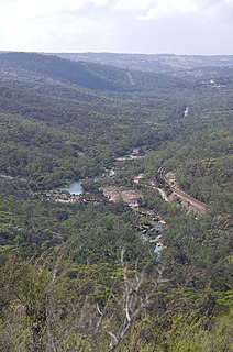
The Avon River is a river in Western Australia. A tributary of the Swan River, the Avon flows 240 kilometres (150 mi) from source to mouth, with a catchment area of 125,000 square kilometres (48,000 sq mi).
Northam is a town in the Australian state of Western Australia, situated at the confluence of the Avon and Mortlock Rivers, about 97 kilometres (60 mi) east-northeast of Perth in the Avon Valley. At the 2016 census, Northam had a population of 6,548. Northam is the largest town in the Avon region. It is also the largest inland town in the state not founded on mining.

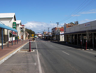
Toodyay, known as Newcastle between 1860 and 1910, is a town on the Avon River in the Wheatbelt region of Western Australia, 85 kilometres (53 mi) north-east of Perth on Ballardong Nyoongar land. The first European settlement occurred in the area in 1836. After flooding in the 1850s, the townsite was moved to its current location in the 1860s. It is connected by railway and road to Perth. During the 1860s, it was home to bushranger Moondyne Joe.

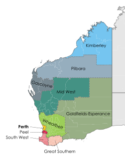
The Wheatbelt is one of nine regions of Western Australia defined as administrative areas for the state's regional development, and a vernacular term for the area converted to agriculture during colonisation. It partially surrounds the Perth metropolitan area, extending north from Perth to the Mid West region, and east to the Goldfields-Esperance region. It is bordered to the south by the South West and Great Southern regions, and to the west by the Indian Ocean, the Perth metropolitan area, and the Peel region. Altogether, it has an area of 154,862 square kilometres (59,793 sq mi).

Great Eastern Highway is a 590-kilometre-long (370 mi) road that links the Western Australian capital of Perth with the city of Kalgoorlie. A key route for road vehicles accessing the eastern Wheatbelt and the Goldfields, it is the western portion of the main road link between Perth and the eastern states of Australia. The highway forms the majority of National Highway 94, although the alignment through the Perth suburbs of Guildford and Midland, and the eastern section between Coolgardie and Kalgoorlie are not included. Various segments form parts of other road routes, including National Route 1, Alternative National Route 94, and State Route 51.

The AvonLink is a passenger train in Western Australia operated by Transwa between Midland and Northam.
James Hasleby, was an English convict transported to Western Australia. He was one of only 37 convicts transported to the colony to overcome the social stigma of convictism to become school teachers, and one of only four convicts to be elected a member of a local Education Board. Notably, given his previous conviction at the Old Bailey, in 1893 he was appointed Clerk of the Local Court at Northampton.

The Shire of Toodyay is a local government area in the Wheatbelt region of Western Australia, beyond the north-eastern limits of the Perth metropolitan area. The Shire covers an area of 1,694 square kilometres (654 sq mi), and its seat of government is the town of Toodyay.

Clackline is a locality in the Wheatbelt region of Western Australia, about 80 kilometres (50 mi) east-north-east of Perth.
The Clackline to Miling railway branch, originally known as the Clackline to Newcastle railway line, is a railway line in Western Australia.

Highways and main roads in the Wheatbelt region of Western Australia form the basis of a road network, which is primarily used by the mining, agriculture, and tourism industries. Main Roads Western Australia maintains and controls these major roads, with offices based in Northam and Narrogin.

Stirling Terrace is the main street of Toodyay, Western Australia, originally called New Road until 1905.
Coondle is a small acre farming estate in the Shire of Toodyay in Western Australia. It started as an estate developed under the provisions of the Agricultural Lands Purchase Act (1896) near what was then known as Newcastle.
The Toodyay Historical Society started in Toodyay as the Toodyay Society in 1980 in conjunction with the Toodyay Tourist Centre. The first annual general meeting was held at the Country Women's Association hall on Stirling Terrace in April 1981.

Avon Yard, originally known as the Avon Marshalling Yard is a railway yard west of Northam, Western Australia.

West Toodyay was the original location of the town of Toodyay, Western Australia. It is situated in the Toodyay valley, 85 kilometres (53 mi) north east of Perth. The Toodyay valley, discovered by Ensign Robert Dale in 1831, was opened up for settlement in 1836. The original site for the town of Toodyay was determined in 1836 and its boundaries were finalized 1838. The first survey of the town was carried out in 1849. After several serious floods, the decision was made to move the town of Toodyay to higher ground. In 1860, the new town of Newcastle was established 3 miles (4.8 km) further upstream. Newcastle was renamed in 1910 to Toodyay, and the original site became known as West Toodyay.

Toodyay railway station is located on the Eastern Railway in the Avon River town of Toodyay in Western Australia.

Northam railway station is located in Northam on the Eastern Railway route in Western Australia. It is the second and more recent railway station in Northam.
This is a list of newspapers published in, or for, the Wheatbelt region of Western Australia.

The Royal Oak established in 1853 by John Herbert was the second inn of that name in West Toodyay. It was also known as Herbert's Hotel. It stood on lot R11, upstream from where the first Royal Oak had been until it closed in November 1851.