
The Hague is a city and municipality of the Netherlands, situated on the west coast facing the North Sea. The Hague is the country's administrative centre and its seat of government, and while the official capital of the Netherlands is Amsterdam, The Hague has been described as the country's de facto capital. The Hague is also the capital of the province of South Holland, and the city hosts both the International Court of Justice and the International Criminal Court.

De Blauwe Aanslag was a squat and self-managed social centre in the Dutch city of The Hague. The oldest part of the building was built in 1886. The large building formerly housed tax offices and was occupied in 1980. When the local council took over the ownership of the building, it was agreed to renovate it in three stages, with the squatters living there. However the plans changed and since 1995 the council decided to widen the roads next to the building; for this reason the squat needed to be demolished. After many efforts to block the demolition with lawsuits, the squatters were evicted by military police on 3 October 2003.

Zuiderparkstadion was an 11,000-seat stadium in The Hague, Netherlands. It was the home of football club ADO Den Haag.
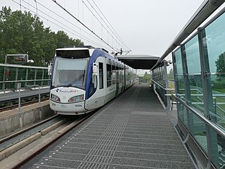
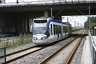
RandstadRail is a light rail network in the Rotterdam–The Hague metropolitan area in the west of the Netherlands that is jointly operated by HTM Personenvervoer (HTM) and Rotterdamse Elektrische Tram (RET). It connects the cities of Rotterdam, The Hague and Zoetermeer, primarily using former train and existing tram tracks.

Leidschenveen-Ypenburg is a Vinex-location and district of The Hague, located in the southeast. It is geographically connected to the main body of the city by only a narrow corridor. It consists of four quarters: Hoornwijk and Ypenburg on the southwest of the A12 motorway and parallel railway to Utrecht, and Forepark and Leidschenveen on the northeast.

Den Haag Centraal is the largest railway station in the city of The Hague in South Holland, Netherlands, and with twelve tracks, the largest terminal station in the Netherlands. The railway station opened in 1973, adjacent to its predecessor: Den Haag Staatsspoor, which was subsequently demolished. It is the western terminus of the Gouda–Den Haag railway.

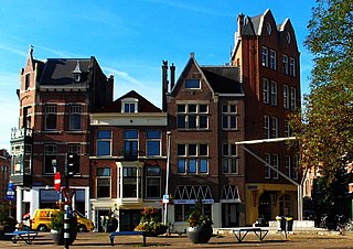
The City Center of The Hague is the oldest and, with a population of 104,658 inhabitants, the second largest of The Hague's eight districts, consisting of nine neighbourhoods. Two railways stations can be found in the city center: Den Haag Centraal and Den Haag Hollands Spoor.

Haagse Hout is one of the eight districts of The Hague. This area was originally called Die Haghe Houte, which later became the current Haagse Hout. The district has 45,600 residents as of 2018. It is located in the north-east of the city, bordering Wassenaar to the north and Leidschendam-Voorburg to the east. Haagse Hout is divided into four neighbourhoods:

Benoordenhout is a neighbourhood in the Haagse Hout district of The Hague. In addition to Benoordenhout, Haagse Hout consists of the Bezuidenhout, Mariahoeve en Marlot, and Haagse Bos neighbourhoods.

Den Haag Ypenburg is a railway station in the Leidschenveen-Ypenburg district of The Hague, Netherlands. It opened on 11 December 2005. It is situated on the Gouda–Den Haag railway.
Escamp is a district of The Hague, Netherlands, built largely after the Second World War, on the 15th century Eskamppolders. With the addition of the Vinex neighbourhood Wateringse Veld, Escamp is the most populous district of the city; as of January 2013, it had 118,483 inhabitants. The district features one railway station: Den Haag Moerwijk.

Forepark is the RandstadRail station in the industrial area of Leidschenveen-Ypenburg, a neighbourhood in The Hague, Netherlands. The station features 2 platforms on either side of a viaduct. These have a high and a low platform, with RandstadRail 3 and RandstadRail 4 using the lower platforms, and line E using the higher platforms.
Zoetermeer Stadslijn is a light-rail line converted from a former commuter rail line in the Netherlands, between The Hague and Zoetermeer.

Spoorwijk is a residential neighbourhood in the Laak district of The Hague, Netherlands. Its name, literally rail neighbourhood or track neighbourhood, originated from the fact that the area borders the Amsterdam–Haarlem–Rotterdam railway on the west. The neighbourhood has 4,161 inhabitants and covers an area of 33,3 ha.

The bombing of the Bezuidenhout took place on 3 March 1945, when the Royal Air Force mistakenly bombed the Bezuidenhout neighbourhood in the Dutch city of The Hague resulting in the death of 532 citizens.
Laak is district of The Hague, Netherlands. With a population of 40,222 and an area of 4.3 square kilometres (1.7 sq mi), it is the smallest and least populous of the city's eight districts. The district is officially divided into three neighbourhoods: Laakkwartier, Spoorwijk and Binckhorst. The Hague University of Applied Sciences can be found in Laak.

The Archipelbuurt is a neighbourhood in the Centrum district of The Hague, Netherlands. It has 5,764 inhabitants and covers an area of 87.1 hectares (0.336 sq mi). Built primarily between 1860 and 1890, the neighbourhood is known for its Neo-Renaissance architecture and wide avenues and streets. Important streets in the Archipelbuurt include the Javastraat, the Surinamestraat, the Scheveningseweg, the Nassauplein and the Burgemeester De Monchyplein. A Jewish graveyard, a chapel and a former city hall of The Hague can be found in the neighbourhood. The Dutch novelist and poet Louis Couperus resided in Javastraat 17. Today, this is the Louis Couperus Museum.
The Zeeheldenkwartier is a neighbourhood in the Centrum district of The Hague, Netherlands. It has 11,205 inhabitants and covers an area of 81.3 hectares (0.314 sq mi). It is bordered by the Carnegielaan, the Zeestraat, the Hoge Wal and the Prinsessewal to the north-east, the Veenkade to the south, the Waldeck Pyrmontkade to the south-west and the Laan van Meerdervoort to the Carnegielaan to the north. Built between 1870 and 1890, the style of the buildings differs between larger houses for important officials near the Willemspark and the Laan van Meerdervoort, and predominantly smaller houses nearer to the city centre. It has also the most Coffeeshops in town. And it has from Albert Heijn the biggest supermarket in town called “Albert Heijn XL”.
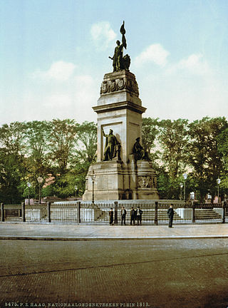
The Willemspark is a neighbourhood in the Centrum district of The Hague, Netherlands. It has 1,393 inhabitants and covers an area of 34.6 hectares (0.134 sq mi). It is bordered by the Zeestraat to the south-east, the Scheveningseveer, the Mauritskade and the Dr. Kuyperstraat to the south-east, the Prinsessegracht to the north-east and the Javastraat to the north-west. The park was originally property of king William II, but he sold the area to the municipality of The Hague in 1855, after which it became a villa park. Iconic to the neighbourhood are the Alexanderstraat and the Sophialaan that intersect on Plein 1813. This square is marked by a monument commemorating the defeat of Napoleon and the establishment of the Sovereign Principality of the United Netherlands.
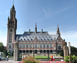
Zorgvliet is a neighbourhood in the Scheveningen district of The Hague, Netherlands. It is named after the estate of the same name, once owned by the poet and writer Jacob Cats,, later by 18th century politician Willem Bentinck van Rhoon and later again becoming the official residence of the Dutch Prime Minister. It has 377 inhabitants and covers an area of 876 hectares (3.38 sq mi). It is bordered by the Laan van Meerdervoort, the Groot Hertoginnelaan, the Stadhouderslaan, the Stadhoudersplantsoen and the Eisenhowerlaan. Zorgvliet is the location of The Hague's "international zone", which is home to the International Criminal Tribunal for the former Yugoslavia, the Organisation for the Prohibition of Chemical Weapons, Europol and the World Forum Convention Center. The Peace Palace, housing the Permanent Court of Arbitration and the International Court of Justice, is also located in Zorgvliet. Moreover, Zorgvliet is the location of the Museum Mesdag, Gemeentemuseum Den Haag and Museon.
