Westbrook is a city in Cumberland County, Maine, United States and a suburb of Portland. The population was 20,400 at the 2020 census, making it the fastest-growing city in Maine between 2010 and 2020. It is part of the Portland–South Portland–Biddeford, Maine metropolitan statistical area.

The Carrabassett River, a tributary of the Kennebec River, is located in Franklin County and Somerset County, Maine, in the United States. It rises near Sugarloaf Mountain, east of Rangeley Lake, and runs for 33.8 miles (54.4 km), flowing southeast past Kingfield and joining the Kennebec River in the town of Anson.
The S. D. Warren Paper Mill is a paper mill on the Presumpscot River in Westbrook, Maine. It is now owned by SAPPI Limited, a South African paper concern. It is one of Westbrook's major employers. The mill complex and former worker and management housing associated with the mill's operation in the 19th century were listed on the National Register of Historic Places in 1974 as the Cumberland Mills Historic District.

The Royal River is a small river, 39 miles (63 km) long, in southern Maine. The river originates in Sabbathday Lake in New Gloucester and flows northeasterly into Auburn and then southerly through New Gloucester, Gray and North Yarmouth into Casco Bay at Yarmouth.

South Windham is a census-designated place (CDP) in the town of Windham in Cumberland County, Maine, United States. The population of the CDP was 1,374 at the 2010 census. Prior to 2010, South Windham was part of the Little Falls-South Windham census-designated place.

The West Branch Penobscot River is a 117-mile-long (188 km) tributary of the Penobscot River through the North Maine Woods in Maine. The river is also known as Abocadneticook, Kahgognamock, and Kettegwewick.

The Brown Company, known as the Brown Corporation in Canada, was a pulp and papermaking company based in Berlin, New Hampshire, United States. They closed their doors during the 1980s.

Yarmouth is a town in Cumberland County, Maine, United States, twelve miles north of the state's largest city, Portland. When originally settled in 1636, as North Yarmouth, it was a district of Massachusetts, and remained as such for 213 years. In 1849, it was incorporated as the Town of Yarmouth, 29 years after Maine's admittance to the Union as the 23rd state.

Great Northern Paper Company was a Maine-based pulp and paper manufacturer that at its peak in the 1970s and 1980s operated mills in Arkansas, Georgia, Maine, and Wisconsin and produced 16.4% of the newsprint made in the United States. It was also one of the largest landowners in the state of Maine.
The historical buildings and structures of Yarmouth, Maine, represent a variety of building styles and usages, largely based on its past as home to almost sixty mills over a period of roughly 250 years. These mills include that of grain, lumber, pulp and cotton. Additionally, almost three hundred vessels were launched by Yarmouth's shipyards in the century between 1790 and 1890, and the homes of master shipwrights and ship captains can still be found throughout the town.
Royal River Park is an urban park in Yarmouth, Maine, United States. It is located to the northwest of the town center, between East Elm Street to the west and Bridge Street to the east. U.S. Route 1 runs through the park via an overpass.

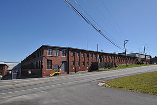
Sparhawk Mill is a former cotton mill on Bridge Street in Yarmouth, Maine, United States. Built in 1840 and made of brick, it is home today to The Garrison restaurant and several other businesses. It stands, just east of the town's Second Falls, on the site of several previous mill buildings, the earliest of which was a wooden mill dating to 1817.
George Warren Hammond was an American businessman. Camp Hammond, in Yarmouth, Maine, is named for him. He was also one of its architects. Built in 1889, it was placed on the National Register of Historic Places in 1979.

Lorenzo L. Shaw, commonly known as L. L. Shaw, was an American businessman who was active in North Yarmouth, Massachusetts, in the 19th century. He was the co-founder of Freeman, Shaw & Co., a cotton mill, and of Pumgustuck Water Company.

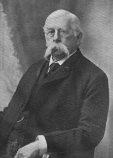
Frederic E. Gore (1860–1930) was a 19th- and 20th-century chemist from Yarmouth, Maine. He became the manager of the Forest Paper Company, which was in business between 1874 and 1923. In 1909, it was the largest such mill in the world.

Yarmouth Marina is a natural harbor and estuary of Casco Bay, and is located adjacent to the town of Yarmouth, Maine, United States. It is situated on the Royal River, around 0.5 miles (0.80 km) southeast of the town center, in an area known as Lower Falls. Today it functions solely as a marina.
Bridge Street is a historic street in Yarmouth, Maine, United States. It runs for about 0.36 miles (0.58 km) from Willow Street in the north to the town's Main Street, State Route 115, in the south. The street's elevation is around 75 feet (23 m) at each end, while its middle section, at its crossing of the Royal River, is around 13 feet (4.0 m), a drop of around 62 feet (19 m).
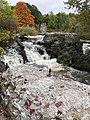
The First Falls are the first of four waterfalls in Yarmouth, Maine, United States. They are located on the Royal River, approximately a mile from its mouth with inner Casco Bay at Yarmouth Harbor and around 0.35 miles (0.56 km) downstream of the Second Falls. The river appealed to settlers because its 45-foot rise in close proximity to navigable water each provided potential waterpower sites. As such, each of the four falls was used to power 57 mills between 1674 and the mid-20th century.

The Second Falls are the second of four waterfalls in Yarmouth, Maine, United States. They are located on the Royal River, approximately 1.35 miles (2.17 km) from its mouth with inner Casco Bay at Yarmouth Harbor, and approximately 0.35 miles (0.56 km) upstream of the First Falls. The river appealed to settlers because its 45-foot rise in close proximity to navigable water each provided potential waterpower sites. As such, each of the four falls was used to power 57 mills between 1674 and the mid-20th century.

The Third Falls are the third of four waterfalls in Yarmouth, Maine, United States. They are located on the Royal River, approximately 2.8 miles (4.5 km) from its mouth with inner Casco Bay at Yarmouth Harbor, and approximately 0.4 miles (0.64 km) upstream of the Second Falls. The river appealed to settlers because its 45-foot rise in close proximity to navigable water each provided potential waterpower sites. As such, each of the four falls was used to power 57 mills between 1674 and the mid-20th century.