
Hydrology is the scientific study of the movement, distribution, and management of water on Earth and other planets, including the water cycle, water resources, and drainage basin sustainability. A practitioner of hydrology is called a hydrologist. Hydrologists are scientists studying earth or environmental science, civil or environmental engineering, and physical geography. Using various analytical methods and scientific techniques, they collect and analyze data to help solve water related problems such as environmental preservation, natural disasters, and water management.

A cloud forest, also called a water forest, primas forest, or tropical montane cloud forest, is a generally tropical or subtropical, evergreen, montane, moist forest characterized by a persistent, frequent or seasonal low-level cloud cover, usually at the canopy level, formally described in the International Cloud Atlas (2017) as silvagenitus. Cloud forests often exhibit an abundance of mosses covering the ground and vegetation, in which case they are also referred to as mossy forests. Mossy forests usually develop on the saddles of mountains, where moisture introduced by settling clouds is more effectively retained.

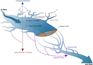
Evapotranspiration (ET) is the combined processes which move water from the Earth's surface into the atmosphere. It covers both water evaporation and transpiration. Evapotranspiration is an important part of the local water cycle and climate, and measurement of it plays a key role in agricultural irrigation and water resource management.
Surface-water hydrology is the sub-field of hydrology concerned with above-earth water, in contrast to groundwater hydrology that deals with water below the surface of the Earth. Its applications include rainfall and runoff, the routes that surface water takes, and the occurrence of floods and droughts. Surface-water hydrology is used to predict the effects of water constructions such as dams and canals. It considers the layout of the watershed, geology, soils, vegetation, nutrients, energy and wildlife. Modelled aspects include precipitation, the interception of rain water by vegetation or artificial structures, evaporation, the runoff function and the soil-surface system itself.
Ecohydrology is an interdisciplinary scientific field studying the interactions between water and ecological systems. It is considered a sub discipline of hydrology, with an ecological focus. These interactions may take place within water bodies, such as rivers and lakes, or on land, in forests, deserts, and other terrestrial ecosystems. Areas of research in ecohydrology include transpiration and plant water use, adaption of organisms to their water environment, influence of vegetation and benthic plants on stream flow and function, and feedbacks between ecological processes, the soil carbon sponge and the hydrological cycle.
Interception refers to precipitation that does not reach the soil, but is instead intercepted by the leaves, branches of plants and the forest floor. It occurs in the canopy, and in the forest floor or litter layer. Because of evaporation, interception of liquid water generally leads to loss of that precipitation for the drainage basin, except for cases such as fog interception, but increase flood protection dramatically, Alila et al., (2009).

In biology, the canopy is the aboveground portion of a plant cropping or crop, formed by the collection of individual plant crowns. In forest ecology, canopy refers to the upper layer or habitat zone, formed by mature tree crowns and including other biological organisms. The communities that inhabit the canopy layer are thought to be involved in maintaining forest diversity, resilience, and functioning. Shade trees normally have a dense canopy that blocks light from lower growing plants.

, water table, and phreatic or saturated zone. (Source: United States Geological Survey.)]]
The United States Environmental Protection Agency (EPA) Storm Water Management Model (SWMM) is a dynamic rainfall–runoff–subsurface runoff simulation model used for single-event to long-term (continuous) simulation of the surface/subsurface hydrology quantity and quality from primarily urban/suburban areas. It can simulate the Rainfall- runoff, runoff, evaporation, infiltration and groundwater connection for roots, streets, grassed areas, rain gardens and ditches and pipes, for example. The hydrology component of SWMM operates on a collection of subcatchment areas divided into impervious and pervious areas with and without depression storage to predict runoff and pollutant loads from precipitation, evaporation and infiltration losses from each of the subcatchment. Besides, low impact development (LID) and best management practice areas on the subcatchment can be modeled to reduce the impervious and pervious runoff. The routing or hydraulics section of SWMM transports this water and possible associated water quality constituents through a system of closed pipes, open channels, storage/treatment devices, ponds, storages, pumps, orifices, weirs, outlets, outfalls and other regulators.
In hydrology, run-on refers to surface runoff from an external area that flows on to an area of interest. A portion of run-on can infiltrate once it reaches the area of interest. Run-on is common in arid and semi-arid areas with patchy vegetation cover and short but intense thunderstorms. In these environments, surface runoff is usually generated by a failure of rainfall to infiltrate into the ground quickly enough. This is more likely to occur on bare soil, with low infiltration capacity. As runoff flows downslope, it may run-on to ground with higher infiltration capacity and then infiltrate.

Canopy interception is the rainfall that is intercepted by the canopy of a tree and successively evaporates from the leaves. Precipitation that is not intercepted will fall as throughfall or stemflow on the forest floor.
In hydrology, stemflow is the flow of intercepted water down the trunk or stem of a plant. Stemflow, along with throughfall, is responsible for the transferral of precipitation and nutrients from the canopy to the soil. In tropical rainforests, where this kind of flow can be substantial, erosion gullies can form at the base of the trunk. However, in more temperate climates stemflow levels are low and have little erosional power.
In hydrology, throughfall is the process which describes how wet leaves shed excess water onto the ground surface. These drops have greater erosive power because they are heavier than rain drops. Furthermore, where there is a high canopy, falling drops may reach terminal velocity, about 8 metres (26 ft), thus maximizing the drop's erosive potential.

Ecological thinning is a silvicultural technique used in forest management that involves cutting trees to improve functions of a forest other than timber production.
IBIS-2 is the version 2 of the land-surface model Integrated Biosphere Simulator (IBIS), which includes several major improvements and additions to the prototype model developed by Foley et al. [1996]. IBIS was designed to explicitly link land surface and hydrological processes, terrestrial biogeochemical cycles, and vegetation dynamics within a single physically consistent framework
The Penman–Monteith equation approximates net evapotranspiration (ET) from meteorological data, as a replacement for direct measurement of evapotranspiration. The equation is widely used, and was derived by the United Nations Food and Agriculture Organization for modeling potential evapotranspiration ET0.
The following outline is provided as an overview of and topical guide to hydrology:
DPHM-RS is a semi-distributed hydrologic model developed at University of Alberta, Canada.

The biotic pump is a theoretical concept that shows how forests create and control winds coming up from the ocean and in doing so bring water to the forests further inland.

The Soil Dryness Index (SDI) uses daily rainfall and maximum temperature from local meteorological stations to estimate soil dryness across tens of kilometers. It estimates the millimeters of rain needed to fill the soil with water. The term was coined by Mount to focus attention on how useful a reliable measure of soil dryness is for flood and fire forecasting and management. Tasmanian government departments, businesses and land managers have used the SDI for these purposes for over 50 years and it is published daily by the Tasmanian Fire Service. Other states in Australia also make use of the SDI.
