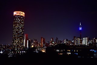
Johannesburg is the most populous city in South Africa with 4,803,262 people, and is classified as a megacity; it is one of the 100 largest urban areas in the world. It is the provincial capital and largest city of Gauteng, which is the wealthiest province in South Africa. Johannesburg is the seat of the Constitutional Court, the highest court in South Africa. Most of the major South African companies and banks have their head offices in Johannesburg. The city is located within the mineral-rich Witwatersrand hills, the epicentre of the international-scale mineral, gold and (specifically) diamond trade.

Midrand is a former municipality in central Gauteng, South Africa. Situated in-between Centurion and Sandton, Midrand now forms part of the City of Johannesburg Metropolitan Municipality.

The International Telecommunication Union (ITU), in its International Radio Regulations, divides the world into three ITU regions for the purposes of managing the global radio spectrum. Each region has its own set of frequency allocations, the main reason for defining the regions.

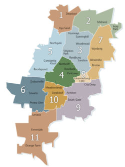
Region 1 was an administrative district in the City of Johannesburg, South Africa, from 2000 to 2006. It is known as the Diepsloot region. It bordered Region 2 (Midrand), Region 3 (Sandton), and Region 5 (Roodepoort). The region was abolished with a reorganisation of regions in 2006.
Region 2 was an administrative district in the City of Johannesburg, South Africa, from 2000 to 2006. It is known as the Midrand region. It bordered Region 3 (Sandton), Region 7 (Modderfontein), and Region 1 (Diepsloot). The region was abolished with a reorganisation of regions in 2006.
Region 3 was an administrative district in the City of Johannesburg, South Africa, from 2000 to 2006, and was also known as the Sandton region, as it included the formerly independent municipality of Sandton, and many of the northern suburbs of the former Johannesburg municipality. It bordered Region 1 (Diepsloot), Region 2 (Midrand), Region 7 (Alexandra), Region 8, Region 4 (Northcliff), and Region 5 (Roodepoort). The region was abolished with a reorganisation of regions in 2006.
Region 4 was an administrative region of the City of Johannesburg, South Africa, from 2000 to 2006, situated almost exactly in the middle of the City of Johannesburg Metropolitan Municipality. It contained the north-western suburbs of Johannesburg as well as western Randburg to the north and Florida to the south-west. Its central and south-eastern area stretches from Bosmont to Pageview, and south of that is the undeveloped belt of land that stretches along Main Reef Road. Starting in the north and proceeding clockwise, it bordered Regions 3, 8, 9, 10, 6, and 5. The region was abolished with a reorganisation of regions in 2006.
Region 5 was an administrative district in the City of Johannesburg, from 2000 to 2006, covering the greater Roodepoort, Randburg, Olivedale and Northriding areas on the western flank of the City of Johannesburg. Its long western boundary forms most of the unicity's western boundary. To the north and east it shared boundaries with largely prosperous residential areas. To the south, it met the northern boundary of Region 6, Doornkop/Soweto. The region was abolished with a reorganisation of regions in 2006.
Region 6 was an administrative district in the City of Johannesburg, from 2000 to 2006, South Africa. It was situated towards the south west of the City of Johannesburg Metropolitan Municipality. It abutted the city's Mining Belt in the north or the southern boundary of Region 5 (Roodepoort) and from there stretched south to meet Region 11. Its western boundary, which projected further west than any other region, formed the periphery of its area of Johannesburg. On the east, Region 6 shared its boundary with the other Soweto region, Region 10. The region was abolished with a reorganisation of regions in 2006.
Region 7 was an administrative district in the City of Johannesburg, South Africa, from 2000 to 2006. It included the densely populated Alexandra township and the town of Modderfontein and was one of Johannesburg's eastern boundary sections, situated in the north-east of the city. Regions 2 (Midrand), 3 (Sandton), and 8 (Central) were to its west, with Midrand also forming its northern boundary. It touched on Region 9 in the south. Its position gives it good access to the City's eastern neighbours, such as Kempton Park and Germiston. The region was abolished with a reorganisation of regions in 2006.
Region 8 was an administrative district from 2000 to 2006 in the City of Johannesburg, South Africa, located in the historic heart of Johannesburg centrally situated on the north-west axis, and towards the eastern border. Surrounding regions, from the north and proceeding clockwise, were Region 3 (Sandton), Region 7 (Alexandra), Region 9, and Region 4 (Northcliff). The southern boundary is the M2 east-west freeway. This region included the Central Business District of the city. The region was abolished with a reorganisation of regions in 2006.
Region 10 was an administrative district from 2000 to 2006 in the City of Johannesburg, South Africa. It included most of Soweto. Soweto is a composite name, standing for South-Western Townships. So even this eastern region of it lay not to the south of central Johannesburg, but south of Florida. Its northern boundary was shared with Region 4 (Florida).
Region 11 was an administrative district in the City of Johannesburg, South Africa, from 2000 to 2006. On a map, Region 11 appeared to hang down from the borders of the two Soweto regions and Johannesburg South. It was about 40 km south of the Inner City. It was the most isolated, least integrated region of Johannesburg, with its east, west and southern borders also forming Johannesburg's boundaries in the area. It was diagonally traversed by the N1 and the Golden Highway, with the N12 running along its northern border. The region was abolished with a reorganisation of regions in 2006.

The suburbs of Johannesburg are officially demarcated areas within the City of Johannesburg Metropolitan Municipality, South Africa. As in other Commonwealth countries, the term suburb refers to a "neighbourhood", although in South Africa most "suburbs" have legally recognised borders and often separate postal codes. The municipal functions for the area, such as municipal policing and social services, are still managed by the city government.

The Highveld is the portion of the South African inland plateau which has an altitude above roughly 1500 m, but below 2100 m, thus excluding the Lesotho mountain regions to the south-east of the Highveld. It is home to some of the country's most important commercial farming areas, as well as its largest concentration of metropolitan centres, especially the Gauteng conurbation, which accommodates one-third of South Africa's population.

The City of Johannesburg Metropolitan Municipality is a metropolitan municipality that manages the local governance of Johannesburg, the largest city in South Africa. It is divided into several branches and departments in order to expedite services for the city. Zulu is the most spoken home language at 23.4% followed by English at 20.1%.
The regions of Iceland are eight areas of Iceland that roughly follow the arrangement of parliamentary constituencies as they were between 1959 and 2003. These regions are not incorporated polities but rather recognized groupings of municipalities. Iceland only has two levels of administration, the national government and 64 municipalities. The municipalities have organized themselves into eight regional associations and those boundaries are also recognized by Statistics Iceland to report statistics. Since 2014, police and commissioner (sýslumaður) districts have followed the eight region model with the exception that Vestmannaeyjar form a special district and are not part of the South region. The divisions of Iceland for the purposes of health care and district courts diverge more from the commonly used eight region model.

Metrorail is an operator of commuter rail services in the major urban areas of South Africa. It is a division of the Passenger Rail Agency of South Africa (PRASA), a state-owned enterprise which is responsible for most passenger rail services in South Africa. The Metrorail system consists of 471 stations, 2,228 kilometres (1,384 mi) of track, and carries an average of 1.7 million passengers per weekday.
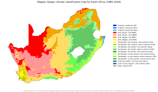
The climate of South Africa is determined by South Africa's situation between 22°S and 35°S, in the Southern Hemisphere's subtropical zone, and its location between two oceans, Atlantic and the Indian.
The regions of Victoria vary according to the different ways that the Australian state of Victoria is divided into distinct geographic regions. The most commonly used regions are those created by the state government for the purposes of economic development.