M2 (Johannesburg)

Last updated

Joburg road M2.svg
Metropolitan route M2
Francois Oberholzer Freeway
Route information
Maintained by Johannesburg Roads Agency and Gauteng Department of Roads and Transport
Length9.4 mi (15.1 km)
Major junctions
West endSA road R41.svg R41 Main Reef Road in Selby Extension, Johannesburg
Major intersectionsM1 ZAF jct blue.svg M1 South - Crown Interchange
M1 ZAF jct blue.svg M1 North - Sandton/Pretoria
M9 ZAF jct.svg M9 Rissik Street, Selby
M11 ZAF jct.svg M11 Mooi Street
M31 ZAF jct.svg M31 Heidelberg Road
M31 ZAF jct.svg M31 Joe Slovo Drive
Maritzburg Street, Kaserne
M19 ZAF jct.svg M19 Ruven Road, Benrose
Chilvers Street, Denver
M33 ZAF jct.svg M33 Cleveland Road
SA road N3 jct.svgSA road N12 jct.svg N3  / N12 Geldenhuis Interchange
East endM93 ZAF jct.svg M93 Refinery Road in Germiston
Location
Country South Africa
Highway system
M1 ZAF jct blue.svg M1 M5 ZAF jct.svg M5

The M2 is a major highway and metropolitan route in Greater Johannesburg, South Africa. It is named the Francois Oberholzer Freeway. It runs just to the south of the Johannesburg Central Business District eastwards where it connects with the N3 (only a short segment goes to the west of the Johannesburg CBD) and enters Germiston, ending near its CBD. The north–south M1 intersects with the M2 just to the south-west of the Johannesburg CBD.

Contents

Route

The M2 route begins just west of the Germiston city centre (capital of Ekurhuleni). [1] :111 It begins by heading westwards from Jack Street at the junction with the M93 Refinery Road, immediately becoming a freeway (Francois Oberholzer Freeway). [1] :111 The motorway continues westwards and reaches the Geldenhuys Interchange with the N3/N12 highway (Johannesburg Eastern Bypass), where it exits Germiston and crosses into Johannesburg. [1] :110 Crossing under the N3 highway, it continues westwards as the road separating the two industrial areas of Heriotdale and Cleveland and reaches its first off-ramp with the M33 Cleveland Road. [1] :110 It continues westward to the Denver Interchange at Chilvers Street. [1] :109 Shortly after that interchange, there is an exit and on-ramp from the M2 West at the M19 Ruven Road and the same for the M2 East intersection at New Goch Road. [1] :109 The motorway continues westward past the Kaserne Railyards to the Maritzburg Street Interchange. [1] :108 A short distance past that interchange, it passes through the Heidelberg Road Interchange. [1] :108 This interchange connects with the M31 North Joe Slovo Drive (which is an eastern bypass of the CBD to the northern suburbs and the M1 North) and the M31 South Heidelberg Road to Alberton. [1] :108 It then passes shortly over the M11 Mooi Street allowing traffic to exit the M2 East and enter the M2 West. [1] :108

Passing over Rosettenville Road, it reaches Eloff Street where off-ramps on M2 West allow exits to Stott Street and the M9 Rissik Street while the M2 East allows an exit to the M9 Rissik Street and an on-ramp from Village Road. [1] :108 Continuing westward it crosses over the M27 Simmonds Street with an on-ramp to the M2 East and then the route crosses Booysens Road and reaches the Westgate Interchange. [1] :107 Here vehicles can enter and exit the M2 from Ntemi Piliso Street, leave the M2 and exit north on the M1 crossing the CBD via the Goch Street double-decker overpass or exit south to M1 and the southern suburbs. [1] :107 The M2 continues westward to the Crown Interchange that allows vehicles from M1 South to head east or west along the M2. [1] :107 Passing through the Crown Interchange, it flies over Treu Road into the suburb of Crown and ends shortly thereafter at a junction with the R41 Main Reef Road, which heads to Roodepoort in the west and the Johannesburg CBD in the north-east. [1] :107

History

The M2 in the afternoon as it passes through the Central Business District The M2 in Johannesburg.jpg
The M2 in the afternoon as it passes through the Central Business District

Both the M2 and M1 motorways have their beginnings in a 1948 traffic planning scheme developed by the Johannesburg City Council and examined by American traffic engineering consultant Lloyd B. Reid in 1954. [2] :577 Two 10-year plans examined among other things the idea of new urban motorways and improving existing highways. The plan called for two motorways, one running east–west along the southern CBD and the other running north–south on the western side of the CBD. [2] :577 The plan was linked to the national and provincial governments plan by the National Transport Commission for the Western and Eastern Bypasses, the future N1 and N3/N12. [2] :577 The East-West Motorway (M2) would have its beginning at the Eastern Bypass now known as the Geldenhuis Interchange, though it presently begins further eastwards in Germiston at Refinery Road. [2] :577

The motorway would then continue westwards over old mining properties and original gold-bearing reefs ending at Main Reef Road near Church Street. [2] :577 The plan was for it to eventually reach the proposed Western Bypass, but it never did. [2] :577 Apart from several diamond interchanges connecting to existing main roads in and out of the city, there would be two large interchanges that would be built on mine dumps. [2] :578 The first would be constructed near New Kazerine and would connect Heidelberg Road to the south and Harrow Road (now Joe Slovo Drive) northwards while the second large interchange, further on, would connect the North-South Motorway (M1) and the later Crown Interchange. [2] :578 Provisions would be made for the vertical and horizontal movement of land due subsidence of undermined land especially where old mine stopes had not been properly filled. [2] :578

A two-three-lane motorway was planned with large medians for breakdowns, elevated where required, and the speed limit set at between 80 and 100 km/h (50 and 60 mph). [2] :577–8 The motorway is named after City of Johannesburg councilor J. F. Oberholzer, who was the head of the council's Works and Traffic committee. [2] :405

Construction

1956

An early long-term motorway plan was envisaged for a future Johannesburg. The first was a north–south motorway of 18.4 km stretching from Westgate just south of the Johannesburg CBD to connect up with the existing main Pretoria Road, 5.6 km outside the Johannesburg municipal boundary in the north suburbs. [3] :328 The Westgate section would connect up with an east/west motorway running just south of the Johannesburg CBD. [3] :328 A third section involved the reconfiguration of roads to form an eastern CBD bypass connecting the north–south motorway with Saratoga Avenue. [3] :328

1958

Improvements began on Harrow Road (Joe Slovo Drive) to widen and deepen the road and included new bridges crossing over it at Joel Road, Alexandra Street and Barnato Street's. [3] :328 Where Harrow Street (Joe Slovo Drive) met Louis Botha Avenue in Berea, this was to become an underpass of the latter. [3] :328 At the southern end of Harrow Road (Joe Slovo Drive), a flyover would cross Saratoga Avenue and would eventually connect in the future with a redesigned Siemert and Sivewright Roads. [3] :328

1962

The construction on the Sivewright Road / Berea Street and the Siemert Road / End Street reconfiguration, important to connecting the future eastern bypass with the M1 in northern suburbs, at the proposed Killarney interchange, with the M2 East at the proposed Heidelberg Interchange, was nearing completion. [3] :329 Both road reconfiguration's were situated in Doornfontein, east of the Johannesburg CBD.

1963

An investigation began on the planned route of the east/west freeway to examine soil quality of the mine dumps and slime dams as well the position and depth of mine tunnels. [3] :329 Contracts were issued for the section of the M2 freeway from the Westgate Interchange eastward to Mooi Street. [3] :329 Contracts were also issued for the planning of the Heidelberg Interchange and its connection to Harrow Road (Joe Slovo Drive) bypass. [3] :329

1964

The Harrow Road (Joe Slovo Drive) scheme was completed. [3] :329 Improvements on Harrow Road (Joe Slovo Drive) widened and deepened the road and included new bridges crossing over it at Joel Road, Alexandra Street and Barnato Street's. [3] :328 Where Harrow Street (Joe Slovo Drive) met Louis Botha Avenue in Berea, this had become an underpass of the latter. [3] :328 Work continued on the Berea-Sivewright motorway bypass works. [3] :329

1965-1966

Work that had started on the eastern-bypass, the Berea-Sivewright Street section, was completed. At the southern end of the M1 Goch Street double-decker section, work began on the Westgate Interchange that would connect the M1 and M2 motorways but work was problematic when mine workings below the site became an issue. [3] :331

1967

The Heidelberg Interchange was put out to tender and would cost R3.9 million. [3] :331 The rest of the M2 motorway was under tender or construction was beginning on the motorway. [3] :331

1968

Work on the Siemert Road / End Street route making up part of the eastern bypass was completed. [3] :331

1970

By this year, the Heidelberg Interchange was nearing completion. [3] :332

1971

Construction of the Crown Interchange that would connect the M1 North–south route with the M2 was postponed when the tenders received were consider too expensive. [3] :332

1972

The Crown Interchange tender on the M1/M2 was finally awarded and a completion date set for 1974. [3] :332 Heidelberg Interchange on the M2 eastern section was opened and connected the eastern CBD bypass to the M1 in the northern suburbs. [3] :332 A section of the M2 freeway between the Maritzberg Interchange and Heriotdale off-ramps had been completed and was opened to traffic between those two sections. [3] :332 Work on the section called the Kazerne Viaduct east of the Heidelberg Interchange was still under way. [3] :332

1973

Part of the route connecting the Crown Interchange to the Westgate Interchange was now open to traffic. [3] :332 Work on the section called the Kazerne Viaduct east of the Heidelberg Interchange was still not completed.

1974

The M2 was now fully open with the completion of the Kazerne Viaduct east of the Heidelberg Interchange. Work connecting the M2 to the N3 Eastern Bypass on the eastern border with Germiston was not completed as the Geldenhuys Interchange was still being built by the Transvaal Roads Department. [3] :333

1978

This year saw the completion and opening of the Geldenhuys Interchange which saw the M2 connected to the N3 Eastern bypass. [3] :334

Final cost

The final cost of the twelve-year M1 and M2 project was R85.5 million through the awarding of twenty-seven contracts. The Provincial and National government's contributed R21 million of the final cost while land acquisitions represented 19% of the final cost. The project moved 8.3 million cubic metres of land made up of 0.3 million cubic metres of rock, 8 million cubic metres of slime and earth. Eighty new bridges were constructed and ten mine dumps moved. Seventy kilometres of drainage pipes were laid and 500,000 cubic metres of concreted poured.

Related Research Articles

<span class="mw-page-title-main">N3 (South Africa)</span> National road in South Africa

The N3 is a national route in South Africa that connects Johannesburg and Durban, respectively South Africa's largest and third-largest cities. Johannesburg is the financial and commercial heartland of South Africa, while Durban is South Africa's key port and one of the busiest ports in the Southern Hemisphere and is also a holiday destination. Durban is the port through which Johannesburg imports and exports most of its goods. As a result, the N3 is a very busy highway and has a high volume of traffic.

<span class="mw-page-title-main">Johannesburg freeways</span> Freeways of Johannesburg, South Africa

Johannesburg is heavily dependent upon freeways for transport around the city due to its location 1,500 metres above sea level, far from the coast or any major bodies of water. There are 10 freeways in the Greater Johannesburg Metropolitan Area: the N1, N3, N12, N14, N17, R21, R24, R59, M1 and M2. In addition, three new freeways are planned: the G5, G9 and G14. Freeways are sometimes called highways or motorways colloquially.

<span class="mw-page-title-main">Johannesburg Ring Road</span> Ring Road in South Africa

The Johannesburg Ring Road is a set of freeways that circle the city of Johannesburg, South Africa and service the City of Johannesburg Metropolitan Municipality. The entire Ring Road is an e-toll highway and is approximately 83 km long.

<span class="mw-page-title-main">N3 Eastern Bypass (Johannesburg)</span> Road in South Africa

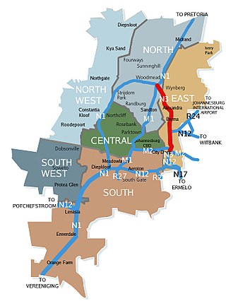
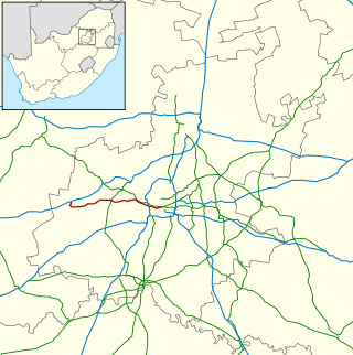
The N3 Eastern Bypass is a section of the Johannesburg Ring Road that forms a beltway around the city of Johannesburg, South Africa, as part of the N3. The first section of the freeway opened in 1971, from Buccleuch to the interchange with Main Reef Road in Germiston. This is one reason why Germiston is listed as the southbound destination of this route, from the Buccleuch to Geldenhuys Interchanges, rather than to the Elands Interchange south of Germiston. The remaining section from Main Reed Road to Black Reef Road, which included the construction of the Geldenhuys Interchange, was opened in 1977, linking the Eastern Bypass with the N3 freeway to Heidelberg. The interchange at Main Reef Road was removed.

<span class="mw-page-title-main">N1 Western Bypass (Johannesburg)</span> Road in South Africa

The Western Bypass is a section of the N1 and the Johannesburg Ring Road located in the city of Johannesburg, South Africa. Known at the time as the Concrete Highway, the freeway was initially opened in 1975 as a route to avoid the city centre of Johannesburg and to provide access to the western areas of the Witwatersrand. From the south, the Western Bypass begins at the Diepkloof Interchange in Soweto, where it splits from the N12 freeway and ends at the Buccleuch Interchange, where it merges with the N3 Eastern Bypass, M1 South and N1 Ben Schoeman freeways.

<span class="mw-page-title-main">N12 Southern Bypass (Johannesburg)</span> Road in South Africa

The N12 Southern Bypass is a section of the Johannesburg Ring Road that forms a beltway around the city of Johannesburg, South Africa, as part of the N12. The freeway was the last section of the Ring Road to be built, with the final section opening in 1986. As part of the old South African Freeways, It was initially called the N13. The entire Southern Bypass freeway is an e-toll highway.

<span class="mw-page-title-main">N1 (South Africa)</span> National road in South Africa

The N1 is a national route in South Africa that runs from Cape Town through Bloemfontein, Johannesburg, Pretoria and Polokwane to Beit Bridge on the border with Zimbabwe. It forms the first section of the famed Cape to Cairo Road.

<span class="mw-page-title-main">R21 (South Africa)</span> Road in South Africa

The R21 is a major north–south provincial route in eastern Gauteng Province, South Africa. Built in the early 1970s, it remains one of two freeways linking Pretoria with Johannesburg, via the R24. As the eastern of the two freeways, it links the Pretoria city centre with OR Tambo International Airport, the N12 freeway, and Boksburg. Between the Solomon Mahlangu Drive on-ramp in Monument Park, Pretoria, and the N12 in Boksburg, the R21 is an 8 lane highway and motorway (freeway), with 4 lanes in each direction. It has off-ramps leading to Irene, Olifantsfontein, Benoni, and Kempton Park, including a partial offramp to Atlas Road. The route intersects the N1 highway near Centurion, the R24 near the airport, the N12 and N17 in Boksburg, and the N3 near Vosloorus on the East Rand, where it ends. The section from the N12 to the N3 is not a freeway. The R21 is also designated as the P157.

<span class="mw-page-title-main">R24 (South Africa)</span> Road in South Africa

The R24 is a major East-West provincial route in the Gauteng and North West provinces that links OR Tambo International Airport with Rustenburg via Johannesburg, Krugersdorp and Magaliesburg. The process of renaming the streets and freeway that form the route from Krugersdorp eastward to OR Tambo International after anti-apartheid stalwart Albertina Sisulu was completed in 2013.

<span class="mw-page-title-main">R29 (South Africa)</span> Road in South Africa

The R29 is a provincial route in South Africa that connects Johannesburg with Leandra and Kinross via Germiston, Boksburg, Benoni and Springs. For much of its route it is named Main Reef Road. The R29 used to end near the Golela border post, however the section from Evander to Ermelo is now part of the N17 and the section from Ermelo to the Golela border post just after Pongola is now part of the N2.

<span class="mw-page-title-main">R41 (South Africa)</span> Road in South Africa

The R41 is a provincial route in Gauteng, South Africa, that connects Johannesburg with Randfontein via Roodepoort.

The R103 is a Regional Route in South Africa that is the designation for some of the old sections of roads that were previously the N3, prior to upgrading. It only has 3 sections, from Hillcrest to Ladysmith, from Warden to Villiers and from Heidelberg to Johannesburg.

The M1 De Villiers Graaff motorway is a metropolitan route and major freeway in the City of Johannesburg, South Africa. The highway connects the southern areas with the city centre and extends further north through Sandton into the Ben Schoeman Highway towards Pretoria. Construction began in 1962 and resulted in the demolition of many properties and houses including numerous historical Parktown Mansions.

<span class="mw-page-title-main">N12 (South Africa)</span> National road in South Africa

The N12 is a national route in South Africa which runs from George through Beaufort West, Kimberley, Klerksdorp and Johannesburg to eMalahleni.

Sydney Bypass refers to a number of roads, existing and proposed, that motorists can use to avoid the congested approaches to the Sydney central business district (CBD). The main bypasses are:

<span class="mw-page-title-main">Ben Schoeman Freeway</span> Road in South Africa

The Ben Schoeman Freeway or Ben Schoeman Highway is the main freeway between Johannesburg and Pretoria, and consists of portions of the M1, N1, and N14. Opened in 1968, it is named after former Minister of Transport Ben Schoeman, and is undoubtedly the busiest road in South Africa.

M16 is a metropolitan route in the Greater Johannesburg metropolitan area, South Africa. It begins in the north-western suburb of Greenside and heads eastwards through some of Johannesburg's northern suburbs and through Edenvale to end at the East Rand town of Kempton Park.

The M31 is a metropolitan route in the City of Johannesburg, South Africa. The road connects the southern suburbs of Alberton with Johannesburg's northern suburbs. The route's eastern bypass in the Johannesburg CBD connects the M2 motorway at the Heidelberg Interchange with M1 North motorway in Houghton and then the route follows the M1 motorway northwards until the M31 ends in Bramley.

The M37 is a metropolitan route in Greater Johannesburg, South Africa. It connects the N3 at Greenstone Shopping Mall with Katlehong via Edenvale and Germiston.

The M46 is a short metropolitan route in Greater Johannesburg, South Africa. It connects Tulisa Park in Johannesburg South with Springs via Germiston, Boksburg and Brakpan.

References

  1. 1 2 3 4 5 6 7 8 9 10 11 12 13 14 15 Street Guide Witwatersrand (8th ed.). MapStudio. 1996.
  2. 1 2 3 4 5 6 7 8 9 10 11 Shorten, John R. (1970). The Johannesburg Saga. Johannesburg: John R. Shorten Pty Ltd. p. 1159.
  3. 1 2 3 4 5 6 7 8 9 10 11 12 13 14 15 16 17 18 19 20 21 22 23 24 25 26 27 "The Johannesburg City Engineer's Department - a century of dedication". Civil Engineering = Siviele Ingenieurswese. 28 (9): 325–335. September 1986 via Sabinet.