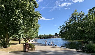
Gidea Park is a neighbourhood in the east of Romford in the London Borough of Havering, south-east England. Predominantly an affluent and residential area, it was historically located in the county of Essex. It saw significant expansion in the early 20th century, with exhibitions of housing and town planning and the construction of a railway station on the main line out from London Liverpool Street station.

Blossom Park is a neighbourhood in Gloucester-Southgate Ward in the south-end of the city of Ottawa, Ontario, Canada. Before the 2001 city of Ottawa amalgamation it was a suburb of the city of Gloucester. The current limits of the neighbourhood are: Hunt Club Road to the north, Airport Parkway to the west, Conroy Road to the east and the Greenbelt to the south.

Alberton is a town situated on the southern part of the East Rand of the Gauteng Province in South Africa and is situated very close to the major urban centre of Johannesburg.
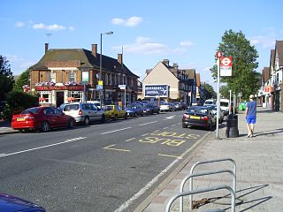
Norbury is an area of south London. It shares the postcode London SW16 with neighbouring Streatham. The area is mainly in the borough of Croydon, with some parts extending into the neighbouring boroughs of Lambeth and Merton. Norbury is 6.7 miles (10.8 km) south of Charing Cross.
Motspur Park, also known locally as West Barnes, is a residential suburb in south-west London, in the New Malden district. It straddles the boroughs of Kingston upon Thames and Merton.

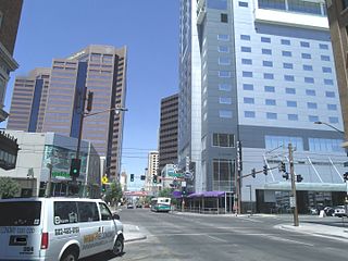
Downtown Phoenix is the central business district (CBD) of the City of Phoenix, Arizona, United States. It is in the heart of the Phoenix metropolitan area or Valley of the Sun. Phoenix, being the county seat of Maricopa County and the capital of Arizona, serves as the center of politics, justice and government on the local, state and federal levels. The area is a major center of employment for the region, with many financial, legal, and other national and international corporations housed in a variety of skyscrapers. Major arts and cultural institutions also call the area home. Downtown Phoenix is a center of major league sports activities, live concert events, and is an equally prominent center of banking and finance in Arizona. Regional headquarters for several major banks, including JP Morgan Chase, Wells Fargo, US Bank, Bank of America, Compass Bank and Midfirst Bank are all located within or close proximity to the area.
Highland Park is a neighborhood in the northeastern part of Pittsburgh, Pennsylvania. Highland Park, the neighborhood, fully encompasses the park with the same name.

Overbrook is a historic neighborhood of Philadelphia, Pennsylvania. It is situated in the northwest of West Philadelphia.
Louis Botha Avenue is a major street in Johannesburg, South Africa. Originally part of the main road between central Johannesburg and Pretoria, it runs along through the north-eastern parts of the city from Hillbrow to Sandton, passing through numerous older suburbs, including Houghton and Orange Grove, before it becomes the Pretoria Main Road at Wynberg and continues to Midrand and Pretoria.

Winston Hills is a suburb of Sydney, in the state of New South Wales, Australia. Winston Hills is located 28 kilometres west of the Sydney central business district in the local government areas of the City of Parramatta and The Hills Shire. Winston Hills is part of the Hills District region of Greater Western Sydney.
Hazelwood Park is an upper class suburb in the City of Burnside, Adelaide, South Australia with a census area population of 1,717 people. The suburb is about 5 kilometres east of the Central business district. Hazelwood Park, a suburban park inside the suburb, is the major attraction in the suburb and is the start of the flat country of the Adelaide Plains at the bottom of the Adelaide Hills. Adjacent Howard Terrace is considered to be the end of the Plains and the start of the foothills. Hazelwood Park includes the Burnside Swimming Centre, a popular site in the summer. Much of the remainder of the suburb is residential but there is a small shopping area along Glynburn Road on the eastern edge. The area was first settled by Europeans in 1848 but has seen many community changes over the years.

Toorak Gardens is a leafy, mainly residential inner eastern suburb of Adelaide, South Australia, located 2 km east of the Adelaide city centre.
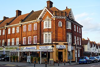
Townhill Park is a suburb of Southampton, England, bordering Swaythling, Bitterne Park and West End. It is built on land which once belonged to the house which carries the same name.

The Old West Austin Historic District is a residential community in Austin, Texas, United States. It is composed of three neighborhoods located on a plateau just west of downtown Austin: Old Enfield, Pemberton Heights, and Bryker Woods. Developed between 1886 and 1953, the three historic neighborhoods stretch from Mopac Expressway east to Lamar Boulevard, and from 13th Street north to 35th Street. It borders Clarksville Historic District and the West Line Historic District to the south.

The F. Q. Story Neighborhood Historic District is located in central Phoenix, Arizona, United States. The neighborhood runs from McDowell Road south to Roosevelt Street and from Seventh Avenue west to Grand Avenue. The neighborhood as well as many of the individual houses are listed on the National Register of Historic Places.

St Marys is a suburb of Adelaide, South Australia, located to the south of the Central Business District. It is bordered by Daws Road (north), South Road (west), Cashel Street (east) and Mill Terrace (south). The suburb is located within the City of Mitcham local government authority. St Marys Park is one of the largest reserves within the suburb and was originally the training ground of the South Adelaide Football Club.
The Central Avenue Corridor is a significant stretch of north–south Central Avenue in Phoenix, Arizona. Roughly bounded by Camelback Road to its north, and McDowell Road to its south, this is one of Phoenix's most vital and heavily trafficked stretches of roads. It is also one of the region's largest centers of employment, with nearly 60,000 people being employed within a three-mile (5 km) radius of this swath of Central Avenue. Major employers here include major banks and financial institutions, hi-tech companies, and several significant law firms and government agencies.
South River City is a community located in Austin, Texas. Also frequently called Travis Heights, the neighborhood is located south of the city's urban core, just below Lake Lady Bird in South Austin. The area encompasses a portion of ZIP code 78704.

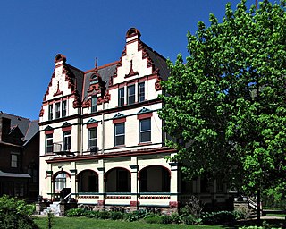
Regal Heights is a neighbourhood located in Toronto, Ontario, Canada. It is classified as a part of the Corso Italia-Davenport neighbourhood by the City of Toronto. and is situated on the western crest of the Davenport escarpment. This neighbourhood has many distinguishing characteristics including very large turn of the century houses, winding tree- lined streets, and an elevation atop the Davenport escarpment. Its main commercial shopping area is along St. Clair Avenue West between Dufferin Street and Oakwood Avenue.

Westdene is a suburb of Johannesburg, South Africa. Westdene lies between the historic suburb of Sophiatown and Melville with the Melville Koppies nature reserve to the north of the suburb. Westdene derives its name from its location, literally meaning west-valley. 'West' since it is located west from the city centre and with 'dene' derived from the Old English denu, meaning valley.

