Northcliff

Last updated

Northcliff
Northcliff (South Africa).jpg
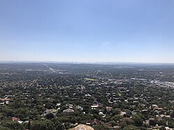
Northcliff seen from Northcliff Hill
South Africa Gauteng location map.svg
Red pog.svg
Northcliff
South Africa adm location map.svg
Red pog.svg
Northcliff
Coordinates: 26°8′46″S27°58′12″E / 26.14611°S 27.97000°E / -26.14611; 27.97000
Country South Africa
Province Gauteng
Municipality City of Johannesburg
Main Place Johannesburg
Established1934
Area
[1]
  Total9.06 km2 (3.50 sq mi)
Population
 (2011) [1]
  Total14,664
  Density1,600/km2 (4,200/sq mi)
Racial makeup (2011)
[1]
   Black African 23.0%
   Coloured 4.9%
   Indian/Asian 7.5%
   White 63.5%
  Other1.2%
First languages (2011)
[1]
   English 55.1%
   Afrikaans 25.4%
   Zulu 4.1%
   Tswana 2.9%
  Other12.5%
Time zone UTC+2 (SAST)
Postal code (street)
2195
PO box
2115

Northcliff is a wealthy residential suburb of Johannesburg, South Africa. The suburb is located on Northcliff Ridge which provides views to both the north and the south. Northcliff's huge homes are nestled around a steep incline of the hill, and on the foot of Northcliff borders the suburbs of Fairland, Blackheath, Cresta and Berario. Recently[ when? ] some streets have been secured with boom gates. It is located in Region B of the City of Johannesburg Metropolitan Municipality.

Contents

History

The suburb is situated on part of an old Witwatersrand farm called Waterval. [2] It was established on 3 October 1934 and named after the northerly ridge. [2]

Geography

Topography

View from Northcliff Ridge (1978) Northcliff1978.jpg
View from Northcliff Ridge (1978)

Northcliff Hill (also known as Aasvoëlkop (Vulture Ridge) due to the cliffs being predominantly inhabited by these birds of prey before being urbanised) is believed to have been populated by humans for over 250,000 years. At 1807 metres, the ridge is the second-highest point in Johannesburg, being one metre lower than Observatory Ridge. It has three vegetation zones and is inhabited by many different animals.

Economy

Retail

Northcliff is served by Cresta Shopping Centre, one of the largest malls in Johannesburg which is located on the border of Northcliff in the suburb of Cresta. Many other smaller suburban shopping complexes are within easy access, for example Northcliff Corner, The Verdi Centre, Heathway Square and Home Living Design Centre.

Education

While actually located in Blackheath, the suburb gives its name to Northcliff High School and Northcliff Primary School.

Infrastructure

Health systems

Marang House, a home for seriously ill children, is based in Northcliff.

Notable residents

Related Research Articles

<span class="mw-page-title-main">Randburg</span> Place in Gauteng, South Africa

Randburg is an area located in the Gauteng province of South Africa. Formerly a separate municipality, its administration devolved to the newly created City of Johannesburg Metropolitan Municipality, along with neighbouring Sandton and Roodepoort, in the late 1990s. During the transitional period of 1996–2000, Randburg was part of the Northern Metropolitan Local Council (MLC).

The area referred to as Fourways is the fastest-developing commercial and residential hub in Sandton, north of Johannesburg, South Africa. The main access routes to Fourways are off the N1 at R511 William Nicol Drive, or alternatively along R564 Witkoppen Road. It is located mostly in Region E of the City of Johannesburg Metropolitan Municipality. It is roughly as far as one can go in the Johannesburg Metropolitan area before it dissolves into rolling hills, game farms and the capital Pretoria, 55 kilometres to the northeast. Hartebeespoort Dam and the Magaliesberg Mountains lie half an hour to the north-west. It is bordered by Bryanston to the east and south and Randburg to the west.

<span class="mw-page-title-main">Suburbs of Johannesburg</span>

The suburbs of Johannesburg are officially demarcated areas within the City of Johannesburg Metropolitan Municipality, South Africa. As in other Commonwealth countries, the term suburb refers to a "neighbourhood", although in South Africa most "suburbs" have legally recognised borders and often separate postal codes. The municipal functions for the area, such as municipal policing and social services, are still managed by the city government.

Ferndale is a suburb of Johannesburg, South Africa. It is located in Region B of the City of Johannesburg Metropolitan Municipality. The area, located in the region of Randburg is very central and has a good mix of residential homes, shops and commercial property.

Kensington is a hilly suburb of Johannesburg, South Africa. It was established in 1897 by Max Langermann. It is located in Region F of the City of Johannesburg Metropolitan Municipality and is bounded to the west by the suburb of Troyeville, to the east by Bedfordview and the north by Bruma and Cyrildene.

Randpark is a suburb of the city of Johannesburg, South Africa. It is located in the northern suburbs of the City of Johannesburg.

Cresta Shopping Centre is a shopping centre in Randburg, South Africa. It is located on the border of Northcliff and Cresta. It has gone through multiple extensions and refurbishments. The mall is owned by Pareto, a unit of the Public Investment Corporation.

Parktown is a wealthy suburb of Johannesburg, South Africa, the first suburb north of the inner city. It is affectionately known as one of the Parks, others including Parkview, Parkwood, Westcliff, Parktown North, Parkhurst and Forest Town. Parktown is one of Johannesburg's largest suburbs, neighbouring Hillbrow, Braamfontein and Milpark to the South; Berea and Houghton to the East; Killarney and Forest Town to the North, and Westcliff, Melville and Richmond to the West. Originally established by the Randlords in the 1890s, Parktown is now home to many businesses, hospitals, schools, churches and restaurants, whilst still maintaining quiet residential areas. It is also home to three of the five campuses of the University of the Witwatersrand including the education campus, medical school and Wits Business School. It is located in Region F of the City of Johannesburg Metropolitan Municipality.

Berario is a suburb of Johannesburg, in the South African province of Gauteng. It is located in Region 4. It is located just below Northcliff Hill and close to Cresta Shopping Centre, one of the biggest malls in South Africa.

Blackheath is a suburb of Johannesburg, South Africa. It is located in Region B of the City of Johannesburg Metropolitan Municipality. Situated north-west of the Johannesburg CBD, it is north of the suburb of Northcliff.

Bosmont is a suburb of Johannesburg, South Africa. Bosmont is located in Region 4. Bosmont is located in the West Rand of Johannesburg and nearly all of its residents are Coloured.

Cresta is a suburb of Randburg, South Africa, situated near the border of Johannesburg.

Linden is a suburb of Johannesburg, South Africa - situated towards the north western suburbs of the city on the border of the former independent town of Randburg. This established suburb between 5 km (3.1 mi) to 8 km (5.0 mi) north-west of the Johannesburg CBD was designed so that most of the streets and avenues form similar sized blocks. A number of shops, churches and schools can be found on 3rd Avenue and 4th Avenue. Attractions include arts, crafts, studios, coffee shops, pubs, restaurants and small shops. Bordering suburbs include Northcliff, Blairgowrie, Victory Park, Greenside and Cresta.

Darrenwood is a suburb in Randburg, South Africa. It lies against the boundary of Johannesburg. Neighbouring suburbs include Linden, Cresta, Aldara Park and Blackheath.

Fairland is a residential suburb in northern Johannesburg, Gauteng, South Africa. The area is neighboured by Northcliff, Cresta and Darrenwood and is one of the most leafy suburbs in the city. Fairland was developed on land that was originally a farm called Weltevreden. Statistics indicate that Fairland has some of the lowest crime statistics within Johannesburg.

Brixton is a predominantly working class suburb of Johannesburg, South Africa. It is the site of the landmark Sentech Tower, and is near the suburbs of Auckland Park and Melville.

Randpark Ridge is an upmarket suburb of Randburg, South Africa. It is located in the Randburg region of the City of Johannesburg. It fell into the town of Randburg during the apartheid era. Developed in the early 1980s and still relatively new, Randpark Ridge is bordered by several other suburbs including Weltevreden Park, Sundowner, Boskruin, Bromhof, Honeydew and Fairland. It is located on the north-west extremity of Johannesburg.

Beyers Naudé Drive is a large arterial route in Johannesburg, South Africa. It starts at the University of Johannesburg in Auckland Park, travelling through Melville, Roosevelt Park, Northcliff, Blackheath and traversing the N1 Western Bypass at Randpark Ridge. It terminates at the N14 freeway near Muldersdrift. It was previously known as DF Malan Drive. It forms part of Johannesburg's M5 road.

Northcliff High School, commonly known as Northcliff High, is a public English medium co-educational high school located in the suburb of Blackheath in Johannesburg in the Gauteng province of South Africa. It is one of the top and most academic schools in Gauteng. The high school was established in 1969.

The M5 is a long metropolitan route in the Greater Johannesburg metropolitan area in South Africa. It starts in Ridgeway in the southern suburbs of Johannesburg. It passes through Mayfair and Brixton before travelling through Melville, Roosevelt Park, Northcliff, Blackheath and traversing the N1 Western Bypass at Randpark Ridge. It passes under the N14 freeway near Muldersdrift passing through the agricultural holding before ending at Kromdraai Road in the Lindley Agricultural Holdings. The main part of the route runs along Beyers Naudé Drive.

References

  1. 1 2 3 4 "Sub Place Northcliff". Census 2011.
  2. 1 2 Raper, Peter E.; Moller, Lucie A.; du Plessis, Theodorus L. (2014). Dictionary of Southern African Place Names. Jonathan Ball Publishers. p. 1412. ISBN   9781868425501.