The area referred to as Fourways is the fastest-developing commercial and residential hub in Sandton, north of Johannesburg, South Africa. The main access routes to Fourways are off the N1 at R511 Winnie Mandela Drive, or alternatively along R564 Witkoppen Road. It is located mostly in Region E of the City of Johannesburg Metropolitan Municipality. It is roughly as far as one can go in the Johannesburg Metropolitan area before it dissolves into rolling hills, game farms and the capital Pretoria, 55 kilometres to the northeast. Hartebeespoort Dam and the Magaliesberg Mountains lie half an hour to the north-west. It is bordered by Bryanston to the east and south and Randburg to the west.

The R25 is a provincial route in South Africa that connects Johannesburg with Groblersdal via Kempton Park, Bapsfontein and Bronkhorstspruit.
Crowthorne is a suburb of Midrand, South Africa. It is located in Region A of the City of Johannesburg Metropolitan Municipality, between Pretoria and Johannesburg on the previously known Carlswald Agricultural Holdings. The region is surrounded by plots, horse breeding societies and agricultural activities; neighbouring areas like Beaulieu, Kyalami, Blue Hills etc. Crowthorne is known for the Crowthorne Shopping Centre, Crowthorne Lodge, new developments by Century Property Developments and several garden centres like the Plantland Nursery.
Halfway House Estate is a suburb of Midrand, South Africa. It is located in Region A of the City of Johannesburg Metropolitan Municipality.

Dunkeld is a suburb of Johannesburg, South Africa. It is located in Region 3. It is bordered by the suburbs of Hyde Park and Illovo to the north, Melrose to the east, Rosebank in the south and to the west, Dunkeld West.
Fellside is a suburb of Johannesburg, South Africa. It is a small suburb located north-east of the city centre with Orange Grove to its north, south and east, with Houghton Estate to its west. It is located in Region E of the City of Johannesburg Metropolitan Municipality.
Houghton Estate, often simply called Houghton, is an affluent suburb of Johannesburg, South Africa, north-east of the city centre.
Melrose includes several suburbs of Johannesburg, South Africa. It is located in Region E of the City of Johannesburg Metropolitan Municipality. Melrose is a developing up-market suburb.
Oaklands is an affluent suburb of Johannesburg, South Africa. It is located in Johannesburg Region E. It is a small suburb surrounded by the suburbs of Houghton Estate, Norwood, Orchards, The Gardens and Highlands North.
Raedene Estate is a suburb of Johannesburg, South Africa. It is found just north of Sydenham. It is located in Region E of the City of Johannesburg Metropolitan Municipality.
Victoria is a suburb of Johannesburg, South Africa. It is located in Region E of the City of Johannesburg Metropolitan Municipality. It is a small suburb located north-east of the city centre surrounded by Norwood to its north, the Houghton Estate to its west and south, while Orange Grove lies to the east.
Louis Botha Avenue is a major street in Johannesburg, South Africa. Originally part of the main road between central Johannesburg and Pretoria, it runs along through the north-eastern parts of the city from Hillbrow to Sandton, passing through numerous older suburbs, including Houghton and Orange Grove, before it becomes the Pretoria Main Road (R101) which passes the Alexandra Township and continues to Midrand and Pretoria.
Greenstone Hill is a suburb on the East Rand in the City of Johannesburg Metropolitan Municipality in the Gauteng province of South Africa. It is in-between Edenvale to the south and Modderfontein to the north.
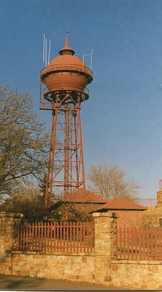
The Yeoville Water Tower is located in Harley and Percy Streets, Yeoville, near the fountain of Doornfontein; it was built in 1914 by the Sivewright's Johannesburg Waterworks, Estate and Exploration company. It was constructed with a reservoir to supply piped water to Johannesburg.
Waverley is a suburb of Johannesburg, South Africa. A suburb in northern Johannesburg, it is surrounded by Bramley, Highlands North and Savoy Estate. It is located in Region E of the City of Johannesburg Metropolitan Municipality. Waverley is located close to the M1 highway, running North and South through Johannesburg.
Bassonia is a southern suburb of Johannesburg, South Africa.
Claremont is a suburb of Johannesburg, South Africa, around 9 km west-northwest of City Hall. Under the old municipal borders, it was one of the westernmost suburbs of the city and bordered Roodepoort.
Rouxville is a suburb of Johannesburg, South Africa, around 8 kilometres (5.0 mi) northeast of City Hall.
Talboton is a suburb of Johannesburg, South Africa, around 7 km northeast of City Hall.
Village Deep is a suburb of Johannesburg, South Africa, around 1.3 km south of City Hall. It is an industrial suburb one kilometer from north to south and less than 300 meters from east to west. To the west is the Genesis Landfill Facility, to the south is the railway and Stafford, to the east is Eloff Street, to the southeast is Robinson Deep, to the northeast is Selby, and to the north is New Centre. Village Deep was founded on February 14, 1934, on Turffontein and Booysen Estate farms. The name, which was originally The Village, comes from the nearby Village Deep Levels gold mine.

