Mohlakeng

Last updated

Mohlakeng
Didi
South Africa Gauteng location map.svg
Red pog.svg
Mohlakeng
South Africa adm location map.svg
Red pog.svg
Mohlakeng
Coordinates: 26°13′32″S27°41′49″E / 26.22556°S 27.69694°E
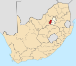
 / -26.22556; 27.69694
Country South Africa
Province Gauteng
District West Rand
Municipality Rand West City Local Municipality
Area
[1]
  Total
7.20 km2 (2.78 sq mi)
Population
 (2011) [1]
  Total
55,033
  Density7,600/km2 (20,000/sq mi)
Racial makeup (2011)
[1]
   Black African 98.7%
   Coloured 0.7%
   Indian/Asian 0.1%
   White 0.3%
  Other0.2%
First languages (2011)
[1]
   Tswana 55.0%
   Xhosa 12.6%
   Zulu 9.3%
   Sotho 7.2%
  Other15.9%
Time zone UTC+2 (SAST)
Postal code (street)
1759
PO box
1766

Mohlakeng is a township west of Johannesburg in Gauteng, South Africa.

Contents

History

The township was established in 1954. The new location of Mohlakeng was established after African residents of the then old Randfontein township of Madubulaville was abolished by the apartheid regime to make way for the industrial site closer to Randfontein town.

Geography

Mohlakeng is where the large part of the Randfontein population is situated. It lies 7 kilometres south of Randfontein, and around 38 kilometres west of Johannesburg. Mohlakeng has now grown about 15% in size in 2012 as compared to 2002.[ citation needed ] The former Executive Mayor[ who? ] of the West Rand District Municipality hails from Mohlakeng.

Infrastructure

The community is served with Umphakathi mall, a police station, Mohlakeng Medical Centre, a refurbished Ramosa Hall, a soccer stadium and a recreation centre.[ citation needed ] Mohlakeng is surrounded by Soweto in the east, Randfontein in the north and Westonaria in the south. Mohlakeng is accessible by the R28 Main Reef Road and the R559 Main Road.

Notable people

Notable people from Mohlakeng include:

References

  1. 1 2 3 4 "Main Place Mohlakeng". Census 2011.