Lesotho Highlands Water Project

Last updated
Katse Dam reservoir and intake tower Katse dam intake tower.jpg
Katse Dam reservoir and intake tower
A 320 metre long WIRTH 529 tunnel boring machine used on the project WIRTH 529 Telescopic Shielded TBM.JPG
A 320 metre long WIRTH 529 tunnel boring machine used on the project
Lesotho Highlands Water Project LHWP map resized.jpg
Lesotho Highlands Water Project

The Lesotho Highlands Water Project (LHWP) is an ongoing water supply project with a hydropower component, developed in partnership between the governments of Lesotho and South Africa. It comprises a system of several large dams and tunnels throughout Lesotho and delivers water to the Vaal River System in South Africa. In Lesotho, it involves the rivers Malibamatso, Matsoku, Senqunyane, and Senqu. It is Africa's largest water transfer scheme.

Contents

The purpose of the project is to provide Lesotho with a source of revenue in exchange for the provision of water to South Africa, as well as generate hydroelectricity for Lesotho. [1] As of 2015, royalties paid by South Africa to the Lesotho government amount to R780 million, equivalent to about 5 percent of Lesotho's state income outside of taxes. [2] The hydro-electric power has enabled Lesotho to become self-sufficient in electricity production, however criticisms have included loss of livelihoods for displaced people and ecological impacts. [3]

History

Efforts to create a dam in the location were spearheaded by then British High Commissioner Sir Evelyn Baring in the 1950s, after initially being conceived by the South African civil engineer Ninham Shand while carrying out investigations commissioned by the British Government into the rivers of Lesotho. [4] As initially conceived, the project was known as the Oxbow Scheme. [4]

After a feasibility study was conducted between August 1983 and August 1986 by the German-British Lahmeyer MacDonald Consortium, the project eventually began to be realized. [5] The project has been alleged to have had negative social and environmental effects. While compensation was provided in kind and paid to the few hundred households affected by the dams, there is criticism that it was insufficient. [6]

In recent years, water from the scheme has been discharged into the Mohokare (Caledon) river to provide water to Maseru in times of critical shortages. [7] The new dams have filled as anticipated and discharge of water from the dams into the downstream rivers continues in a scheme devised to preserve ecological balances. This discharged water flows to the Senqu (Orange) and while preserving the ecological status quo benefits only those communities along the rivers.[ citation needed ]

The project has had an important impact on Lesotho's infrastructure, as hundreds of kilometers of engineered paved roads were built in order to improve access to the different construction sites, together with engineered unpaved 'feeder' roads around the dams. [8]

Since its inception, the project has been dogged by corruption which has resulted in a number of court cases involving both individuals and multinational corporations. [9]

Project features

Below is an overview of the main features of the first three phases of the project.

Phase IAPhase IBPhase IIPhase III
NameKatse DamMohale DamPolihali Dam [10] Tsoelike Dam
Dam height (m)185145165155
Power generation [lower-alpha 1] (MW)

(installed capacity)

110does not generate power3-8 (potentially) [10] N/A
Water transfer capacity [lower-alpha 1] (m³/s)16.910.128.0[ citation needed ]8.6
Transfer tunnelsYesYesYesNo
Delivery tunnelsYesNoNoNo
Completed1998 [11] 2003 [11] Under Construction (Estimated completion end of 2028) [12] No (On hold) [13]
  1. 1 2 The values are estimates based on the feasibility study, and may differ from the current or eventual values, respectively.

Phase I

Phase of the project comprises all the essential components to impound water in the Katse Dam, generate electricity and deliver water to the Vaal River System. Phase I has been carefully configured so that Katse Dam remains the common link to further phases identified during feasibility studies. In line with the phased approach, Phase I consists of Phase IA comprising the essential components, and Phase IB which enhances the yield of the project with the addition of two peripheral sources namely the Mohale Dam and the Matsoku Weir.

Phase IA

This phase of the project was completed in 1998. It consisted mainly of the construction of the Katse Dam on the Malibamat'so River in Lesotho. A 45-kilometre (28 mi) transfer tunnel was built from the Katse Dam to the Muela Reservoir. The Muela Reservoir is considered to be the tail pond, which supplies hydroelectric power for Lesotho. Stemming from the Muela Reservoir is a 37-kilometre (23 mi) delivery tunnel to the outfall at the As River from where water flows to the Vaal Dam. Although the Katse Dam has power generation capability for local use, the primary purpose is as the storage reservoir for Phase IA, and to provide discharge into the transfer tunnel.

To mitigate loss of habitat, the Katse Botanical Gardens was established to house plants that were rescued from the area to be flooded. [14]

Phase IB

Mohale Dam and reservoir Mohale Dam 2008.jpg
Mohale Dam and reservoir

This phase of the project was completed in 2002. It consisted mainly of the construction of:

The system is interconnected in such a way that water may be transferred in either direction for storage in Mohale or ultimate transfer to South Africa through the Katse reservoir.

Phase II

The CEO of the LHWP implementing body of the Lesotho Highlands Development Authority (LHDA), Refiloe Tlali, said: "the 2.3-billion cubic metre Polihali dam will be built downstream of the confluence of the Senqu and Khubelu rivers. The dam will have a 163.5 m high concrete-faced rockfill embankment dam wall. The crest length will be 915 m, with a full supply level of 2,075 m above sea level. A 49.5 m high saddle dam and spillway will also be built." [17]

Upon completion phase 2 will enable over 400 million cubic metres of water to flow from Lesotho to the Vaal Dam and will move the total volume of water being transferred from Lesotho to South Africa to over 1.27 billion cubic metres per year. The Trans Caledon Tunnel Authority will raise most of the R40 billion required to complete phase 2. [18]

In August 2023, the Trans-Caledon Tunnel Authority (TCTA) secured funding from the New Development Bank amounting to 3.2 billion South African rand (approx. US$172 million) to be applied to the continuation of Phase 2. This loan is in addition to US$86.72 million borrowed from the African Development Bank as well as funding from other sources. The engineering, procurement and construction (EPC) contractor is a consortium comprising Salini Impregilo and Cooperativa Muratori Cementistri (CMC di Ravenna), both from Italy, CMI Infrastructure Company of South Africa and LSP Construction of Lesotho. Completion of phase 2 is expected in 2028. [19]

Later phases

The As River Outfall is situated 9 km north of Clarens and was opened in 1998. The As delivers water to the Saulspoort Dam and Liebenbergsvlei and Wilge Rivers beyond, where after the water enters the Vaal Dam. Asrivieruitval, noord van Clarens, b.jpg
The As River Outfall is situated 9 km north of Clarens and was opened in 1998. The As delivers water to the Saulspoort Dam and Liebenbergsvlei and Wilge Rivers beyond, where after the water enters the Vaal Dam.
The discharge point in the Little Caledon River east of Clarens, which serves as a conduit to the Caledon (or Mohokare) River. Klein-Caledonrivieruitval, Clarens, Vrystaat.jpg
The discharge point in the Little Caledon River east of Clarens, which serves as a conduit to the Caledon (or Mohokare) River.

As initially conceived, three further dams were proposed further downstream after the Malibamatso joins the Senqu river, at Mashai, Tsoelike, and Ntoahae.

In 2007, further studies resulted in a modification, proposing instead a dam on the Senqu, upstream from its confluence with the Malibamatso. This is currently the preferred extension of the scheme, although construction has not yet begun (as of November 2021). [20]

See also

Related Research Articles

<span class="mw-page-title-main">Lesotho</span> Country in Southern Africa

Lesotho, formally the Kingdom of Lesotho, is a landlocked country in Southern Africa. As an enclave of South Africa, with which it shares a 1,106 km border, it is the only sovereign enclave in the world outside of the Italian Peninsula. It is situated in the Maloti Mountains and contains the highest peak in Southern Africa. It has an area of over 30,000 km2 (11,600 sq mi) and has a population of about 2 million. Its capital and largest city is Maseru.

<span class="mw-page-title-main">Geography of Lesotho</span> Landlocked country in Africa

Lesotho is a mountainous, landlocked country located in Southern Africa. It is an enclave, surrounded by South Africa. The total length of the country's borders is 909 kilometres (565 mi). Lesotho covers an area of around 30,355 square kilometres (11,720 sq mi), of which a negligible percentage is covered with water.

<span class="mw-page-title-main">Orange River</span> Major river in southern Africa

The Orange River is a river in Southern Africa. It is the longest river in South Africa. With a total length of 2,432 km (1,511 mi), the Orange River Basin extends from Lesotho into South Africa and Namibia to the north. It rises in the Drakensberg mountains in Lesotho, flowing westwards through South Africa to the Atlantic Ocean. The river forms part of the international borders between South Africa and Lesotho and between South Africa and Namibia, as well as several provincial borders within South Africa. Except for Upington, it does not pass through any major cities. The Orange River plays an important role in the South African economy by providing water for irrigation and hydroelectric power. The river was named the Orange River in honour of the Dutch ruling family, the House of Orange, by the Dutch explorer Robert Jacob Gordon. Other names include simply the word for river, in Khoekhoegowab orthography written as !Garib, which is rendered in Afrikaans as Gariep River with the intrusion of a velar fricative in place of the alveolar click, Groote River or Senqu River, derived from ǂNū "Black". It is known in isiZulu as isAngqu.

<span class="mw-page-title-main">Vaal River</span> Tributary of the Orange River, South Africa

The Vaal River is the largest tributary of the Orange River in South Africa. The river has its source near Breyten in Mpumalanga province, east of Johannesburg and about 30 kilometres (19 mi) north of Ermelo and only about 240 kilometres (150 mi) from the Indian Ocean. It then flows westwards to its confluence with the Orange River southwest of Kimberley in the Northern Cape. It is 1,458 kilometres (906 mi) long, and forms the border between Mpumalanga, Gauteng and North West Province on its north bank, and the Free State on its south.

<span class="mw-page-title-main">Vaal Dam</span> Dam in South Africa

The Vaal Dam in South Africa was constructed in 1938 and lies 77 km south of OR Tambo International Airport, Johannesburg. The lake behind the dam wall has a surface area of about 320 square kilometres (120 sq mi) and is 47 meters deep. The Vaal Dam lies on the Vaal River, which is one of South Africa's strongest-flowing rivers. Other rivers flowing into the dam are the Wilge River, Molspruit and Grootspruit. It has over 800 kilometres (500 mi) of shoreline and is South Africa's second biggest dam by area and the fourth largest by volume.

<span class="mw-page-title-main">Katse Dam</span> Dam in Lesotho

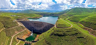
The Katse Dam, a concrete arch dam on the Malibamat'so River in Lesotho, is Africa's second largest double-curvature arch dam.. The dam is part of the Lesotho Highlands Water Project, which will eventually include five large dams in remote rural areas. The dam is just below the confluence of the Bokong River, which forms the western arm of the Katse reservoir.

<span class="mw-page-title-main">Caledon River</span> Major river in Lesotho and South Africa

The Caledon River is a major river located in central South Africa. Its total length is 642 km (399 mi), rising in the Drakensberg Mountains on the Lesotho border, flowing southwestward and then westward before joining the Orange River near Bethulie in the southern Free State. The river was originally named Prinses Wilhelminas Rivier in 1777, by Colonel R J Gordon.

<span class="mw-page-title-main">Gariep Dam</span> Dam in Border of Eastern Cape and Free State, South Africa

The Gariep Dam is located in South Africa, near the town of Norvalspont, bordering the Free State and Eastern Cape provinces. Its primary purpose is for irrigation, domestic and industrial use as well as for power generation.

<span class="mw-page-title-main">Concor</span> South African construction company

Concor Holdings (Proprietary) Limited. is a South African construction and mining services company. It is active throughout Southern Africa, involved in civil engineering, buildings, roads and mining projects. Concor returned as an independent brand in late 2016.

<span class="mw-page-title-main">Mohale Dam</span> Dam in Lesotho

Mohale Dam is a concrete faced rock-fill dam in Lesotho. It is the second dam, under Phase 1B of the series of dams of the proposed Lesotho Highlands Water Project (LHWP), which will eventually include five large dams in remote rural areas of Lesotho and South Africa. The project has been built at a cost of US$1.5 billion.

<span class="mw-page-title-main">Senqunyane River</span> River in Lesotho

The Senqunyane River is a river of central Lesotho. The river rises in the Maluti Mountains in northwest Lesotho, and flows southwards and then westwards for 120 kilometres before joining the Senqu River in the southwest.

<span class="mw-page-title-main">Malibamat'so River</span>

The Malibamat'so River is a river in northern Lesotho. Its origin is near to the South African border, where it drains the eastern slopes of the Maloti Range. It flows southwards past the village of Lejone, and eventually joins the Senqu River 5 kilometres (3.1 mi) northeast of Mohlanapeng.

<span class="mw-page-title-main">Sterkfontein Dam</span> Dam in Free State

The Sterkfontein Dam, located just outside the town of Harrismith, in the Free State, province of South Africa, is part of the Tugela-Vaal Water Project and the Drakensberg Pumped Storage Scheme, and located on the Nuwejaarspruit, a tributary of the Wilge River in the upper catchment area of the Vaal River. It is the second highest dam wall in South Africa and its highest earth fill dam.

Upper Orange WMA, or Upper Orange Water Management Area , Includes the following major rivers: the Modder River, Riet River, Caledon River and Orange River, and covers the following Dams:

<span class="mw-page-title-main">As River</span> River in South Africa

The As River is a tributary of the Liebenbergsvlei River in the eastern Free State, South Africa. Since 1968 it is impounded by the Sol Plaatje Dam at its confluence with the latter river, just east of Bethlehem. Its origin is some 35 km southeast of Bethlehem, on the northern slopes of the Rooiberge, near Clarens. With the opening of the northern delivery tunnel of the Lesotho Highlands Water Project in 1998, the once tiny stream was transformed to a strong-flowing river.

<span class="mw-page-title-main">Wilge River</span> River in South Africa

The Wilge River is a tributary of the Vaal River in central South Africa. This river is important as part of the Tugela-Vaal Water Transfer Scheme where water is transferred from the Tugela River basin to the Vaal River basin.

<span class="mw-page-title-main">Lesotho–South Africa border</span> International border

The border between Lesotho and South Africa is 909 kilometres (565 mi) long and forms a complete loop, as Lesotho is an enclave entirely surrounded by South Africa. The border follows the Caledon River, the drainage divide of the Drakensberg mountains, the Orange River, the Makhaleng River, and a series of hills joining the Makhaleng back to the Caledon.

Lesotho is a mountainous and fairly 'water-rich country', but suffers from a lack of clean drinking water due to inadequate sanitation. In recent decades, with the construction of dams for the Lesotho Highlands Water Project (LHWP), Lesotho has become the main provider of water to parts of northern South Africa. Despite the economic and infrastructure development occasioned by the LHWP, waterborne diseases are common in the country and the infant mortality rate from them is high. In 2017, a project to improve the rural water supply in the Lesotho Lowlands was funded by the Global Environment Facility and the African Development Bank, and is ongoing.

<span class="mw-page-title-main">Tugela Vaal Transfer Scheme</span> South African irrigation project

The Tugela Vaal water Transfer Scheme is an irrigation project developed in the Drakensberg mountains at the Oliviershoek Pass in South Africa.

The Polihali Dam is a dam under construction in Lesotho. Dam construction started in 2022. The dam is part of the Phase II of the Lesotho Highlands Water Project.

References

  1. "Home | LHDA". www.lhda.org.ls. Retrieved 2020-11-24.
  2. Rousselot, Yannick (31 December 2015). "Upstream Flows of Water: from the Lesotho Highlands to Metropolitan South Africa: Territorialities and Hydropolitics in Southern Africa". Revue de géographie alpine (103–3). doi: 10.4000/rga.3023 .
  3. Keketso, Lawrence (February 2003). "The Mixed Blessings of the Lesotho Highlands Water Project: An Assessment Based on Local Perspectives". Mountain Research and Development. 23 (1): 7–10. doi: 10.1659/0276-4741(2003)023[0007:TMBOTL]2.0.CO;2 .
  4. 1 2 Unknown (1970). "Obituary: Ninham Shand, BSc". Proceedings of the Institution of Civil Engineers. 45 (2). ICE Virtual Library: 379–380. doi:10.1680/iicep.1970.7187 . Retrieved 9 October 2021. In 1953, while carrying out investigations commissioned by the British Government into the rivers of the Lesotho, Shand first conceived the idea of diverting the headwaters of the Orange River from an altitude of some 10 000 ft in the Lesotho Mountains to augment the limited water supplies available for the Witwatersrand and Orange Free State. This pioneering concept became known as the Oxbox Scheme, itself a single element of a much wider plan which captured the imagination of the people of Lesotho.
  5. Lang, Chris; Hildyard, Nick; Geary, Kate; Grainger, Matthew (28 February 2000). "Lahmeyer International". Dams Incorporated. The Corner House.
  6. Hoover, Ryan (2001). Pipe Dreams - The World Bank's Failed Efforts to Restore Lives and Livelihoods of Dam-Affected People in Lesotho (PDF) (Report). International Rivers Network. Archived from the original (PDF) on 19 August 2007.
  7. Letsie, M.; Allopi, D.; Osorio, A.; Goldschmith, A.; Edelman, D. A. (July 2008). "Maqalika Reservoir: utilisation and sustainability of Maqalika Reservoir as a source of potable water supply for Maseru in Lesotho". IMIESA. 33 (7): 23–33. hdl: 10204/4170 . ISSN   0257-1978.
  8. Kolver, Leandi (27 March 2014). "Lesotho Highlands Water Project Phase 2 launched". Engineering News.
  9. Earle, Anton; Turton, Anthony (2005). Corruption on the Lesotho Highlands Water Project - a case study (PDF). World Water Week 2005. Stockholm: Stockholm International Water Institute. Archived from the original (PDF) on 28 September 2007.
  10. 1 2 "LHWP Phase II - Engineering". Lesotho Highlands Development Authority. 2015. Retrieved 1 October 2015.
  11. 1 2 "Lesotho Highlands Water Project". European Investment Bank. 26 November 2002. Retrieved 17 August 2021.
  12. Moraes, Chriselle (2023-05-25). "Construction Begins On Phase 2 Of The Lesotho Highlands Water Project". Construct Africa.
  13. 1 2 Oirere, Shem (April 2021). "Pandemic Puts Hold on Southern Africa's Water Tunnel Projects". Underground Construction. Vol. 76, no. 4.
  14. "Katse Botanic Garden". Botanic Gardens Conservation International . Retrieved 9 December 2016.
  15. "LHWP Phase II - Milestones". Lesotho Highlands Development Authority. 2015. Retrieved 1 October 2015.
  16. Oirere, Shem (April 2021). "Pandemic Puts Hold on Southern Africa's Water Tunnel Projects". Underground Construction. Retrieved 2021-11-08.
  17. James, Nadine (29 July 2016). "Phase II update: Polihali dam construction expected in 2019". Engineering News.
  18. Moraes, Chriselle (2023-05-25). "Construction Begins On Phase 2 Of The Lesotho Highlands Water Project". Construct Africa.
  19. Inès Magoum (23 August 2023). "BRICS Summit: $170m announced for the LHWP water project in South Africa". Afrik21.africa. Paris, France. Retrieved 24 August 2023.
  20. "The Lesotho Highlands Water Project: Environmental Flow Allocations in an International River" (PDF). International Union for Conservation of Nature . Retrieved 17 August 2021.