
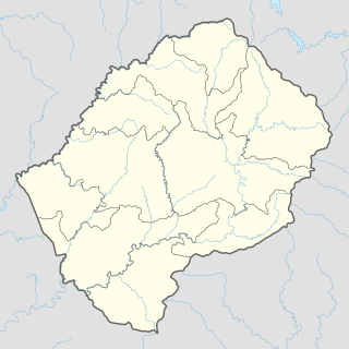
Lesotho is a mountainous, landlocked country located in Southern Africa. It is an enclave, surrounded by South Africa. The total length of the country's borders is 909 kilometres (565 mi). Lesotho covers an area of around 30,355 square kilometres (11,720 sq mi), of which a negligible percentage is covered with water.

Politics of Lesotho takes place in a framework of a parliamentary representative democratic constitutional monarchy, whereby the Prime Minister of Lesotho is the head of government, and of a multi-party system. Executive power is exercised by the government. Legislative power is vested in both the government and the two chambers of Parliament, the Senate and the National Assembly. The Judiciary is independent of the executive and the legislature.

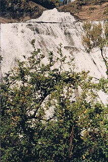
The Orange River is a river in Southern Africa. It is the longest river in South Africa. The Orange River Basin extends extensively from Lesotho into South Africa and Namibia to the north. It rises in the Drakensberg mountains in Lesotho, flowing westwards through South Africa to the Atlantic Ocean. The river forms part of the international borders between South Africa and Lesotho and between South Africa and Namibia, as well as several provincial borders within South Africa. Except for Upington, it does not pass through any major cities. The Orange River plays an important role in the South African economy by providing water for irrigation and hydroelectric power. The river was named the Orange River in honour of the Dutch ruling family, the House of Orange, by the Dutch explorer Robert Jacob Gordon. Other names include simply the word for river, in Khoekhoegowab orthography written as !Garib, which is rendered in Afrikaans as Gariep River with the intrusion of a velar fricative in place of the alveolar click, Groote River or Senqu River, derived from ǂNū "Black".

The Free State is a province of South Africa. Its capital is Bloemfontein, which is also South Africa's judicial capital. Its historical origins lie in the Boer republic called the Orange Free State and later Orange Free State Province.
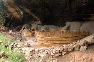
Berea is a district of Lesotho. In the west, Berea borders on the Free State Province of South Africa. Domestically, it borders on the following districts: Leribe District in the north, Thaba-Tseka District in southeast and Maseru District in the south. Teyateyaneng is the capital of the district. It is also home to the Kome Cave Dwellings. It is also the only district in Lesotho which is not named after its capital.
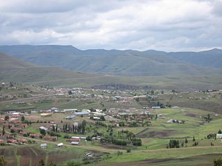
Thaba-Tseka is a district of Lesotho. Thaba-Tseka is also the name of the district's capital or camptown, which is the only town in the district. In the east, Thaba-Tseka borders on the KwaZulu-Natal Province of South Africa. Domestically, it borders on Mokhotlong District in northeast, Leribe District in north, Berea District in northwest, Maseru District in west, Mohale's Hoek District in southwest and Qacha's Nek District in the southern direction. The district is one of the major tourist attractions in Lesotho because of the second largest arch dam in Africa Katse Dam.

Maseru is a district of Lesotho. Maseru is also the name of the district's capital, and is the only city in the district and also the capital of the country. It is the largest urban area in the country, and therefore the only city. The city of Maseru is located on Lesotho's western border with the Free State Province of South Africa, the frontier being the Caledon River. Maseru borders on Berea District in north, Thaba-Tseka District in the east, Mohale's Hoek District in south, and Mafeteng District in southwest.
Mohale's Hoek is a district of Lesotho. Mohale's Hoek is the capital city or camptown, and only town in the district. In the southwest, Mohale's Hoek borders on South Africa, while domestically, it borders on Mafeteng District in northwest, Maseru District in north, Thaba-Tseka District in northeast, Qacha's Nek District in east, and Quthing District in southeast.
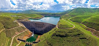
The Katse Dam, a concrete arch dam on the Malibamat'so River in Lesotho, is Africa's second largest double-curvature arch dam.. The dam is part of the Lesotho Highlands Water Project, which will eventually include five large dams in remote rural areas. The dam is just below the confluence of the Bokong River, which forms the western arm of the Katse reservoir.

The Lesotho Highlands Water Project (LHWP) is an ongoing water supply project with a hydropower component, developed in partnership between the governments of Lesotho and South Africa. It comprises a system of several large dams and tunnels throughout Lesotho and delivers water to the Vaal River System in South Africa. In Lesotho, it involves the rivers Malibamatso, Matsoku, Senqunyane, and Senqu. It is Africa's largest water transfer scheme.

The rock-catfish, Austroglanis sclateri, is a species of catfish in the family Austroglanididae. This freshwater fish is endemic to the Vaal River in South Africa. It is also found in Lesotho and Namibia.

Mohale Dam is a concrete faced rock-fill dam in Lesotho. It is the second dam, under Phase 1B of the series of dams of the proposed Lesotho Highlands Water Project (LHWP), which will eventually include five large dams in remote rural areas of Lesotho and South Africa. The project has been built at a cost of US$1.5 billion.
The Makhaleng River is a river of western Lesotho. It rises in the Maluti Mountains, flows generally in a southwesterly direction to join the Orange River at the border with Free State in South Africa.

The Malibamat'so River is a river in northern Lesotho. Its origin is near to the South African border, where it drains the eastern slopes of the Maloti Range. It flows southwards past the village of Lejone, and eventually joins the Senqu River 5 kilometres (3.1 mi) northeast of Mohlanapeng.
Sehonghong is a community council located in the Thaba-Tseka District of Lesotho. Its population in 2006 was 5,814. The village of Sehonghong is located between Taung and Matebeng on the Senqu River.
The Sehlabathebe National Park is located in the Maloti Mountains in Qacha's Nek District, Lesotho, and is part of the larger Maloti-Drakensberg World Heritage Site. Home to both striking biological diversity as well as important cultural heritage, the park was first established on May 8, 1969. The landscape is dominated by grassland of various types. The larger ecosystem as a whole performs invaluable functions including providing freshwater to Lesotho, South Africa and Namibia.
Upper Orange WMA, or Upper Orange Water Management Area , Includes the following major rivers: the Modder River, Riet River, Caledon River and Orange River, and covers the following Dams:
Boskop Dam is an earth-fill type dam on the Mooi River, near Potchefstroom, North West Province, South Africa. It was constructed in 1959. The main purpose of the dam is for irrigation and domestic usage. Its hazard potential is ranked as high, due to poor maintenance and the development of sink holes.
Klipdrif Dam is an earth-fill type dam located on the Loopspruit and Enselspruit near Potchefstroom, North West, South Africa. The river flowing out the dam is the Loopspruit. It was established in 1990 and its primary purpose is to serve for irrigation. The hazard potential of the dam has been ranked significant (2).

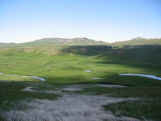
The Lesotho Highlands are formed by the Drakensberg and Maloti mountain ranges in the east and central parts of the country of Lesotho. Foothills form a divide between the lowlands and the highlands. Snow is common in the highlands in the winter.


