
Lesotho is a mountainous, landlocked country located in Southern Africa. It is an enclave, surrounded by South Africa. The total length of the country's borders is 909 kilometres (565 mi). Lesotho covers an area of around 30,355 square kilometres (11,720 sq mi), of which a negligible percentage is covered with water.

The Orange River is a river in Southern Africa. It is the longest river in South Africa. With a total length of 2,432 km (1,511 mi), the Orange River Basin extends from Lesotho into South Africa and Namibia to the north. It rises in the Drakensberg mountains in Lesotho, flowing westwards through South Africa to the Atlantic Ocean. The river forms part of the international borders between South Africa and Lesotho and between South Africa and Namibia, as well as several provincial borders within South Africa. Except for Upington, it does not pass through any major cities. The Orange River plays an important role in the South African economy by providing water for irrigation and hydroelectric power. The river was named the Orange River in honour of the Dutch ruling family, the House of Orange, by the Dutch explorer Robert Jacob Gordon. Other names include simply the word for river, in Khoekhoegowab orthography written as !Garib, which is rendered in Afrikaans as Gariep River with the intrusion of a velar fricative in place of the alveolar click, Groote River or Senqu River, derived from ǂNū "Black". It is known in isiZulu as isAngqu.

Mokhotlong district is a district of Lesotho. It includes the highest terrain in the Maloti Mountains and the source of the Senqu River, Lesotho's primary watershed. Mokhotlong is the capital or camptown, and only town in the district. Mokhotlong borders on the KwaZulu-Natal Province of South Africa, with its north point bordering the Free State Province. Domestically, it borders on Butha-Buthe District in northwest, Leribe District in west, and Thaba-Tseka District in the south.
Mokhotlong is a city and seat of Mokhotlong District in the mountainous northeastern part of Lesotho. It is the first major city with an airport along the road from South Africa across the Sani Pass, near the Maloti Mountains. The name of the city is a word in Sesotho, the language of the people of Lesotho, meaning "Place of the Bald Ibis." Thabana Ntlenyana, the highest point in southern Africa, is found in Mokhotlong.

Mohlabi Kenneth Tsekoa is a Lesotho politician who was Minister of Foreign Affairs of Lesotho from 2007 to 2015. He served in the Cabinet beginning in July 2001, first as Minister of Finance, then as Foreign Minister, Minister of Education, and starting in March 2007 as Foreign Minister again.

The Alima River is a tributary of the Congo River. It is formed by the confluence of two streams, the Lékéti and the Dziélé.

The NossobRiver is a dry river bed in eastern Namibia and the Kalahari region of South Africa and Botswana. It covers a distance of 740 km and last flooded in 1989. The river also lends its name to Nossob camp 25°25′18″S20°35′47″E in the Kgalagadi Transfrontier Park.

The Lesotho Highlands Water Project (LHWP) is an ongoing water supply project with a hydropower component, developed in partnership between the governments of Lesotho and South Africa. It comprises a system of several large dams and tunnels throughout Lesotho and delivers water to the Vaal River System in South Africa. In Lesotho, it involves the rivers Malibamatso, Matsoku, Senqunyane, and Senqu. It is Africa's largest water transfer scheme.

The Ontonagon River is a river flowing into Lake Superior at the village of Ontonagon, on the western Upper Peninsula of Michigan in the United States. The main stem of the river is 25 miles (40 km) long and is formed by a confluence of several longer branches, portions of which have been collectively designated as a National Wild and Scenic River. Several waterfalls occur on the river including Agate Falls and Bond Falls.
The Weißeritz is a river of Saxony, Germany. It is 13.7 km [8.5 mi] long and a left tributary of the Elbe.

The Senqunyane River is a river of central Lesotho. The river rises in the Maluti Mountains in northwest Lesotho, and flows southwards and then westwards for 120 kilometres before joining the Senqu River in the southwest.

The Williams River is a perennial stream that is a tributary of the Hunter River, in the Hunter Region of New South Wales, Australia.
Ouray is an unincorporated village of the Uintah and Ouray Indian Reservation, located in west‑central Uintah County, Utah, United States.
Mokhotlong Airport is an airport serving Mokhotlong, the camptown of Mokhotlong District, Lesotho.
Tlokoeng Airport is an airport serving the village of Tlokoeng in Mokhotlong District, Lesotho.
Letseng Airport is an airstrip serving the Letseng diamond mine in Mokhotlong District, Lesotho. The runway is at very high elevation, 10,084.8 feet.
Malefiloane Airstrip is a high elevation airstrip serving the village of Malefiloane in Mokhotlong District, Lesotho. The runway is on a ridge above the Mokhotlong River valley.
Semenanyane Airport is a well-marked airstrip serving the mission village of Semenanyane in Mokhotlong District, Lesotho. The runway is near the border with Thaba-Tseka District.
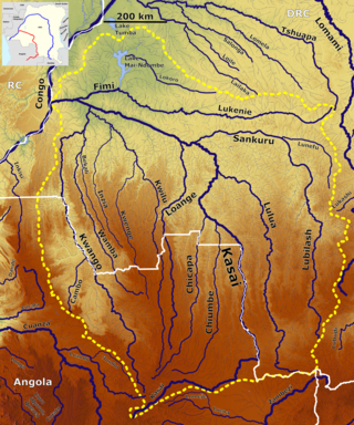
The Wamba River is a river in the Democratic Republic of the Congo (DRC) and Angola. It arises at an elevation of around 3,250 feet (990 m) as the confluence of several small streams in the Lunda Norte Province of Angola, a region of low hills and shallow ravines. In Angola it is known as the Uamba River.
