Mohale Dam

Last updated
Mohale Dam
Mohaledam.jpg
Mohale Dam
Official nameMohale Dam
Location Lesotho
Coordinates 29°27′24.20″S28°05′45.18″E / 29.4567222°S 28.0958833°E / -29.4567222; 28.0958833 Coordinates: 29°27′24.20″S28°05′45.18″E / 29.4567222°S 28.0958833°E / -29.4567222; 28.0958833
Opening date2003-04
Dam and spillways
Type of dam Embankment, concrete faced rock-fill
Impounds Senqunyane River
Height145 metres (476 ft)
Length700 metres (2,300 ft)
Dam volume7,500,000 m3 (9,809,630 cu yd)
Spillway capacity6,000 m3/s (211,888 cu ft/s)
Reservoir
Total capacity1.0 km3 (810,713 acre⋅ft)

Mohale Dam is a concrete faced rock-fill dam in Lesotho. It is the second dam, under Phase 1B of the series of dams of the proposed Lesotho Highlands Water Project (LHWP), which will eventually include five large dams in remote rural areas of Lesotho and South Africa. [1] The project has been built at a cost of US$1.5 billion. [2]

Contents

The Mohale Dam was awarded the 2005 Fulton Awards by the Concrete Society of South Africa as having the "Best Construction Engineering Project and Best Construction Technique." [3]

Geography

The dam is built across the Senqunyane River below its confluence with the western tributary, the Likalaneng River. [4] Investigation of the dam site in the "Highlands of Lesotho" has revealed "rounded, steep sided valleys" where the soil cover is thin and basaltic lava is the dominant formation. [5] The dam site has been identified with two geological features of faults which needed treatment measures. [6] The dam is located 100 kilometres (62 mi) to the east of Maseru, which is the capital of Lesotho. [7] The dam drains a catchment area of 938 square kilometres (362 sq mi) over a river length of 60 kilometres (37 mi) with an elevation variation of 1,050 metres (3,440 ft). [4]

Background

The importance of the large water resources potential of the country, one of the various natural resources of the land-locked country. Subsequently, Director of Public Works, requested an engineer to examine the potential of the project as a possible means to supplement the water supply needs in South African gold mines. [8] [9]

In 1983, the World Bank began implementing the project. Phase I covered some of the key strategic components of the project, while Phase IB's financing covered not only engineering design and supervision of the main works but an institutionalized framework with a panel of experts in the field of engineering and the environmental and social aspects of the project. The Development Bank of Southern Africa (DBSA), the European Investment Bank (IIB), and Export Credit agencies were also approached to finance the project. [10]

The Lesotho Highlands Water Project (LHWP) was established, with the objective of supplying water to the Gauteng region of South Africa and for hydroelectric power to meet the needs of Lesotho. A treaty signed between the government of Lesotho and South Africa gave the green light for the project, and the team was set up to implement the project. [11] [12] The treaty is limited to Phases IA and IB only. [13] The Trans-Caledon Tunnel Authority (TCTA), vested with the operation and maintenance aspects of the project is guided by the larger establishment of the Lesotho Highlands Development Authority (LHDA). [14] The project envisages diverting water in the highlands of the country through three dams; two under Phase I (PhaseI A -Katse Dam and Phase II - Mohale Dam) and the Polihali Dam under Phase II. Construction of the Phase I dams were completed in 2003 and formally commissioned in 2004. [11] [12]

Features

The Mohale Dam Mohale Dam 2008.jpg
The Mohale Dam

The Mohale Dam under Phase I B of the LHWP, is designed to divert about 70 cubic metres (2,500 cu ft) per second of storage to the Katse Dam reservoir. The water supply meets the needs of the Gauteng region which encompasses the mining and industrial cities of Johannesburg and Pretoria. [7] The regulated flow from the reservoir is 9.5 cubic metres (340 cu ft) per second which is transferred as gravity flow through the interconnecting concrete lined tunnel of 32 kilometres (20 mi) length with an internal diameter of 3.4 metres (11 ft). [15]

Mohale Dam is categorized as a high dam, and at 145 metres (476 ft) in height it is said to be the highest rock-fill concrete-face dam (CFRD) in Africa. It is built as an embankment dam with a rock-fill concrete-face on the upstream side. The volumetric content of the dam structure is 7.5 million m³. The dam has a length of 700 metres (2,300 ft) with a 12 metres (39 ft) wide crest. The spillway, located on the left bank of the dam, is not gated and flood is routed over the crest of the ogee shaped spillway through a concrete lined chute with a flip bucket and a stilling basin at its terminus. The concrete spillway is designed for a flood discharge of 6,000 cubic metres (210,000 cu ft) per second.

Safety measures

The geological features at the dam site were evaluated for possibilities of displacement. The treatment measures implemented to address this condition involved excavation of a trench of 15 metres (49 ft) width and 2 metres (6 ft 7 in) depth below the toe slab which is meant to function as a concrete "socle". A grout curtain was also created through the "lineament" (fault line) and a grouting gallery was provided for the purpose that covered the downstream part of the embankment up to the toe-slab area near the lineament. Both the "socle" and the toe-slab incorporate movement joints consisting of 20 millimetres (0.79 in) compressible materials and a PVC water stop. A layer of earth fill is also laid on the upstream part of the toe slab over a width of 70 metres (230 ft), and on the downstream side protection includes a geo-textile and "reverse filters of 2D and 2E material". [6]

Temporary cofferdams and river diversions

A temporary 300 000m3 cofferdam, with a pre-cofferdam, were built in mid-1999.

River diversion was effected through two concrete lined diversion tunnels constructed on the left bank. The diversion tunnels are 650 metres (2,130 ft) and 560 metres (1,840 ft) long, and have a cross-section of 6.70 by 5.50 metres (22.0 ft × 18.0 ft). [7] [16] The intake for water transfer is located 5 kilometres (3.1 mi) upstream of the dam face on the left bank. [16]

Aggregate

Approximately 13 000m3 of rock was placed every day. Two quarries were used; one to supply the bulk of the rock for the rock-fill and the other for the higher quality doleritic basalt used in the concrete aggregate and filter layers in the dam.

Concrete

The total quantity of concrete contained in the dam is 30,000 cubic metres (1,100,000 cu ft). The concrete facing on the upstream face of the dam was constructed concurrently at two levels. The lower part of the concrete slab was laid up to two thirds height of the dam from the bottom while the top one third face was also concurrently laid. This special construction method facilitated early completion of the dam. The dam is said to be one of the top ten concrete faced embankment dams in the world. [16]

Submergence

The project's reservoir submergence involved some of the most fertile agricultural land in the area. The project affected 390 households and some 1700 people. [17]

Related Research Articles

Vaal Dam Dam in Border Gauteng and Free State

The Vaal Dam in South Africa was constructed in 1938 and lies 77 km south of OR Tambo International Airport. The lake behind the dam wall has a surface area of about 320 square kilometres (120 sq mi) and is 47 meters deep. The Vaal Dam lies on the Vaal River, which is one of South Africa's strongest-flowing rivers. Other rivers flowing into the dam are the Wilge River, Klip River, Molspruit and Grootspruit. It has over 800 kilometres (500 mi) of shoreline and is South Africa's second biggest dam by area and the fourth largest by volume.

Katse Dam Dam in Lesotho

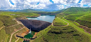
The Katse Dam, a concrete arch dam on the Malibamat'so River in Lesotho, is Africa's second largest double-curvature arch dam.. The dam is part of the Lesotho Highlands Water Project, which will eventually include five large dams in remote rural areas. The dam is just below the confluence of the Bokong River, which forms the western arm of the Katse reservoir.

Lesotho Highlands Water Project

The Lesotho Highlands Water Project (LHWP) is an ongoing water supply project with a hydropower component, developed in partnership between the governments of Lesotho and South Africa. It comprises a system of several large dams and tunnels throughout Lesotho and delivers water to the Vaal River System in South Africa. In Lesotho, it involves the rivers Malibamatso, Matsoku, Senqunyane, and Senqu. It is Africa's largest water transfer scheme.

Copeton Dam Dam in New England, New South Wales, Australia

Copeton Dam is a major clay core and rock fill embankment dam with nine radial gates and a gated concrete chute spillway across the Gwydir River upstream of Bingara in the New England region of New South Wales, Australia. The dam's purpose includes environmental flows, hydro-electric power generation, irrigation, and water supply. The impounded reservoir is called Lake Copeton.

Windamere Dam Dam in Central Tablelands, New South Wales

Windamere Dam is a minor ungated rock fill with clay core embankment dam with an uncontrolled unlined rock cutting spillway across the Cudgegong River at Cudgegong in the Mid-Western Region Council, New South Wales, Australia. It is upstream of Mudgee in the Central Tablelands region. The dam's purpose includes hydro-power, irrigation, water supply, and conservation. The impounded reservoir is called Lake Windamere.

Blowering Dam Dam in Snowy Mountains, New South Wales

The Blowering Dam is a major ungated rock fill with clay core embankment dam with concrete chute spillway impounding a reservoir under the same name. It is located on the Tumut River upstream of Tumut in the Snowy Mountains region of New South Wales, Australia. Purposes for the dam include flood mitigation, hydro-power, irrigation, water supply and conservation. The dam is part of the Snowy Mountains Scheme, a vast hydroelectricity and irrigation complex constructed in south-east Australia between 1949 and 1974 and now run by Snowy Hydro.

Googong Dam Dam in Queanbeyan, New South Wales

Googong Dam is a minor ungated earth and rock fill with clay core embankment dam with concrete chute spillway plus a nearby 13 metres (43 ft) high earthfill saddle embankment across the Queanbeyan River upstream of Queanbeyan in the Capital Country region of New South Wales, Australia. The dam's purpose includes water supply for Canberra and Queanbeyan. The impounded reservoir is called Googong Reservoir.

Toker Dam

Toker Dam is the fourth largest dam in Eritrea. Construction was begun in 1997 and completed in 2001, despite having to be halted for a few months in 1998 when Ethiopia and Eritrea were at war. Its primary designer was Natural Resources Consulting Engineers from Colorado, USA. Furthermore, NRCE Inc., was the primary consultant on the project. The construction contractor was Keagnam of South Korea.

Haditha Dam Dam in Al Anbar, Iraq

The Haditha Dam or Qadisiya Dam is an earth-fill dam on the Euphrates, north of Haditha (Iraq), creating Lake Qadisiyah. The dam is just over 9 kilometres (5.6 mi) long and 57 metres (187 ft) high. The purpose of the dam is to generate hydroelectricity, regulate the flow of the Euphrates and provide water for irrigation. It is the second-largest hydroelectric contributor to the power system in Iraq behind the Mosul Dam.

Split Rock Dam Dam in North West Slopes, New South Wales

Split Rock Dam is a minor ungated concrete faced rock fill embankment dam with concrete chute spillway across the Manilla River upstream of Manilla in the north-western slopes region of New South Wales, Australia. The dam's purpose includes flood mitigation, irrigation, water supply and conservation. The impounded reservoir is called Split Rock Reservoir.

Pindari Dam Dam in North West Slopes, New South Wales

Pindari Dam is a minor concrete faced rockfill embankment dam with an ungated uncontrolled rock cut with concrete sill spillway across the Severn River located upstream of the town of Ashford, in the North West Slopes region of New South Wales, Australia. The dam's purpose includes flood mitigation, hydro-power, irrigation, water supply and conservation. The impounded reservoir is called Lake Pindari.

Talbingo Dam Dam in Snowy Mountains, New South Wales

Talbingo Dam is a major ungated rock fill with clay core embankment dam with concrete chute spillway across the Tumut River upstream of Talbingo in the Snowy Mountains region of New South Wales, Australia. The impounded reservoir is called Talbingo Reservoir.

Chaffey Dam Dam in Tamworth, New South Wales, Australia

Chaffey Dam is a minor ungated rock fill with clay core embankment dam with an uncontrolled morning glory spillway across the Peel River, located upstream of the city of Tamworth, in the New England region of New South Wales, Australia. The dam's purpose includes flood mitigation, irrigation, water supply, and water conservation.

Senqunyane River

The Senqunyane River is a river of central Lesotho. The name means Little Orange River in Sotho. The river rises in the Maluti Mountains in northwest Lesotho, and flows southwards and then westwards for 120 kilometres before joining the Senqu River in the southwest.

Badush Dam Dam in Badush, Ninawa Governorate, Iraq

The Badush Dam is an unfinished multi-purpose dam on the Tigris River, located near Badush, 16 kilometres (9.9 mi) northwest of Mosul in the Ninawa Governorate, northern Iraq.

Bento Munhoz Hydroelectric Plant Dam in Foz do Areia, Paraná, Brazil

The Governor Bento Munhoz da Rocha Netto Hydroelectric Plant, formerly known as Foz do Areia, is dam and hydroelectric power plant on the Iguazu River near Foz do Areia in Paraná, Brazil. It is the furthest dam upstream of the Iguazu Falls and was constructed between 1976 and 1980. The power station has a 1,676 megawatts (2,248,000 hp) capacity and is supplied with water by a concrete face rock-fill embankment dam.

Itumbiara Dam Dam in Itumbiara, Goiás, Brazil

The Itumbiara Dam is an embankment dam on the Paranaíba River near Itumbiara in Goiás, Brazil. The dam serves an associated hydroelectric power plant with a 2,082 megawatts (2,792,000 hp) installed capacity. The power plant is the sixth largest in Brazil and has the largest installed capacity of Eletrobrás Furnas' power plants.

Oberon Dam Dam in Central Tablelands, New South Wales

Oberon Dam or Fish River Dam is a major ungated concrete slab and buttress with earth embankment dam comprising a concrete ski jump chute spillway and fuse plug across the Fish River upstream of Oberon in the Central Tablelands region of New South Wales, Australia. The dam's purpose includes flood mitigation, industrial, and water supply. The impounded reservoir is called Lake Oberon.

Murray Two Dam Dam in Snowy Mountains, New South Wales

Murray Two Dam or Murray 2 Dam is a major ungated concrete arch dam with a controlled spillway across Khancoban Bank, a diverted flow of the Snowy and Geehi rivers in the Snowy Mountains region of New South Wales, Australia. The impounded reservoir is called the Murray Two Pondage or Murray 2 Pondage.

Brogo Dam Dam in South Coast, New South Wales

Brogo Dam is a minor ungated rockfill embankment dam with an uncontrolled unlined rock cut spillway across the Brogo River upstream of Brogo in the South Coast region of New South Wales, Australia. The dam's purpose includes environmental flows, hydro-electric power generation, irrigation, and water supply. The impounded reservoir is also called Brogo Dam.

References

  1. "Welcome to LHWP Phase I". Lesotho Highlands Development Authority. Archived from the original on 16 September 2016. Retrieved 20 June 2015.
  2. McDonald 2004, p. 224.
  3. Haas, Mazzei & O'Leary 2010.
  4. 1 2 Consortium & Consortium 1986, p. 37.
  5. Consortium & Consortium 1986, p. H.5.1.
  6. 1 2 Fell et al. 2005, p. 634.
  7. 1 2 3 "Mohale Dam - highlands water project - phase 1b". Salini Impreglio. Retrieved 20 June 2015.
  8. Official SADC trade, industry, and investment review. Southern African Marketing Company. 2003. ISBN   9780620299190.
  9. Dennill 2001, p. 1.
  10. Haas, Mazzei & O'Leary 2010, p. xiv.
  11. 1 2 "About LHWC". Lesotho Highlands Development Authority.
  12. 1 2 "The Lesotho Highlands Water Project (LHWP): Project Description". Lesotho Highlands Development Authority. Retrieved 20 June 2015.
  13. United Nations Environment Programme (2010). Africa Water Atlas. UNEP/Earthprint. pp. 11–. ISBN   978-92-807-3110-1.
  14. "Welcome to the Lesotho Highlands Water Commission". Lesotho Highlands Development Authority. Retrieved 20 June 2015.
  15. Lesotho Highlands Water Project. Thomas Telford. 1997. pp. 13–. ISBN   978-0-7277-2621-6.
  16. 1 2 3 "Mohale Dam". Department of Water and Sanitation, Republic of South Africa. Archived from the original on 4 March 2016. Retrieved 20 June 2015.
  17. Bennett & McDowell 2012, p. 7.

Bibliography