As River

Last updated
As River
Asrivier naby Saulspoortdam, Bethlehem, Vrystaat.jpg
South Africa relief location map.svg
Red pog.svg
Location
Country South Africa
Province Free State
Physical characteristics
Source 
  coordinates 28°30′38″S28°21′47″E / 28.51056°S 28.36306°E / -28.51056; 28.36306
  elevation2,160 m (7,090 ft)
Mouth  
  coordinates
28°16′36″S28°22′22″E / 28.27667°S 28.37278°E / -28.27667; 28.37278 Coordinates: 28°16′36″S28°22′22″E / 28.27667°S 28.37278°E / -28.27667; 28.37278
  elevation
1,630 m (5,350 ft)
Length50 km (31 mi)
Discharge 
  average18 m3/s (640 cu ft/s)

The As River is a tributary of the Liebenbergsvlei River in the eastern Free State, South Africa. Since 1968 it is impounded by the Sol Plaatje Dam (formerly: Saulspoort Dam) at its confluence with the latter river, just east of Bethlehem. Its origin is some 35 km southeast of Bethlehem, on the northern slopes of the Rooiberge, near Clarens. With the opening of the northern delivery tunnel of the Lesotho Highlands Water Project in 1998, the once tiny stream was transformed to a strong-flowing river. [1]

Free State (province) Province of South Africa

The Free State is a province of South Africa. Its capital is Bloemfontein, which is also South Africa's judicial capital. Its historical origins lie in the Boer republic called Orange Free State and later Orange Free State Province.

South Africa Republic in the southernmost part of Africa

South Africa, officially the Republic of South Africa (RSA), is the southernmost country in Africa. It is bounded to the south by 2,798 kilometres (1,739 mi) of coastline of Southern Africa stretching along the South Atlantic and Indian Oceans; to the north by the neighbouring countries of Namibia, Botswana, and Zimbabwe; and to the east and northeast by Mozambique and Eswatini (Swaziland); and it surrounds the enclaved country of Lesotho. South Africa is the largest country in Southern Africa and the 25th-largest country in the world by land area and, with over 57 million people, is the world's 24th-most populous nation. It is the southernmost country on the mainland of the Old World or the Eastern Hemisphere. About 80 percent of South Africans are of Bantu ancestry, divided among a variety of ethnic groups speaking different African languages, nine of which have official status. The remaining population consists of Africa's largest communities of European, Asian (Indian), and multiracial (Coloured) ancestry.

Sol Plaatje Dam dam in Free State, South Africa

Sol Plaatje Dam is an earth-fill type dam located at the confluence of the As and Liebenbergsvlei Rivers near Bethlehem, Free State, South Africa. It was established in 1968 and serves mainly for municipal and domestic water supply. The hazard potential of the dam has been ranked high. The reservoir receives water from the Lesotho Highlands Water Project via the As River.

Contents

Water delivery

The As River Outfall of the Lesotho Highlands Water Project, situated 9 km north of Clarens, was opened in 1998. Asrivieruitval, noord van Clarens, b.jpg
The As River Outfall of the Lesotho Highlands Water Project, situated 9 km north of Clarens, was opened in 1998.

The As River is one of the discharge points for the Lesotho Highlands Water Project. [2] As of 2004, 18 cubic meters of water was released per second, [1] and the river's flow is consequently not seasonally variable. [3]

The Stortemelk Dam, situated downstream of the outfall, was one measure taken by the then Department of Water Affairs, to stabilize water flow and limit erosion. [3] By 2004, four weirs had been built. [1]

Power generation

Two privately owned hydro powered power plants, the Sol Plaatje and Merino, were commissioned in 2009 and 2012 respectively, and supply a total of 7 MW to the power grid. [4] The automated and low maintenance Stortemelk Hydropower Project at the Botterkloof Dam is set to contribute a further 4.4 MW to the power grid, starting July 2016. [3] [5]

Bethlehem Hydro owns and operates two small hydro power plants situated in the Dihlabeng Local Municipality in the Free State province of South Africa. The scheme utilizes the water supplied to South Africa by the Lesotho Highlands Water Project, which releases water into the As River via a tunnel outlet near the town of Clarens. South Africa has limited potential for hydro energy due to low average annual rainfall making projects like Bethlehem Hydro rare. The project was identified in 1999 and developed by NuPlanet Project Development. The two power stations in the scheme will cut back carbon dioxide emissions by 33,000 tons per year by reducing the demand for traditional fossil-fuel power stations.

The watt is a unit of power. In the International System of Units (SI) it is defined as a derived unit of 1 joule per second, and is used to quantify the rate of energy transfer. In dimensional analysis, power is described by .

Ecological impact

The opening of the northern delivery tunnel in 1998 caused physical and chemical changes to the river, as water volumes increased and water temperature decreased, scouring of the river channel occurred, and much silt was deposited in Saulspoort Dam. [1] Populations of key indicator species like smallmouth and largemouth yellowfish decreased, and seven of the river's nine fish species disappeared from the outfall's vicinity. Recovery of invertebrates was only noticeable some kilometers downstream, and the weirs proved ineffective when water is released in high volumes. Though much habitat is still available, the river's population by aquatic organisms is limited by water turbidity, low water temperature and its erosion potential. [1]

Smallmouth yellowfish species of fish

The smallmouth yellowfish is a species of ray-finned fish in the genus Labeobarbus. It has become an invasive species in rivers of the Eastern Cape, South Africa, such as the Mbhashe River.

Largemouth yellowfish species of Actinopterygii

The largemouth yellowfish or Vaal-Orange largemouth yellowfish is a ray-finned fish species in the family Cyprinidae. This large freshwater barb is found in southern Africa.

Etymology

The name is often mistranslated from Afrikaans to English as "Ash River". The name, however, refers to a wagon axle which, according to legend, broke near the river (the Afrikaans word for an axle being “as”); therefore a correct translation would be "Axle River", and not “Ash River".

Afrikaans West Germanic language spoken in South Africa and Namibia

Afrikaans is a West Germanic language spoken in South Africa, Namibia and, to a lesser extent, Botswana and Zimbabwe. It evolved from the Dutch vernacular of Holland spoken by the largely Dutch settlers in the south-west of what is now South Africa, where it gradually began to develop distinguishing characteristics in the course of the 18th century. Hence, it is a daughter language of Dutch.

Ox-wagon

An ox-wagon or bullock wagon is a four-wheeled vehicle pulled by oxen. It was a traditional form of transport, especially in Southern Africa but also in New Zealand and Australia. Ox-wagons were also used in the United States. The first recorded use of an ox-wagon was around 1670, but they continue to be used in some areas up to modern times.

See also

Related Research Articles

Orange River major river of southern Africa

The ǂNūǃarib (Senqu) "Black River", IGqili, or under the colonial name, Orange River, is the longest river in Lesotho and the Orange River Basin extends extensively into South Africa, Namibia and Botswana to the north. It rises in the Drakensberg mountains in Lesotho, flowing westwards through South Africa to the Atlantic Ocean. The river forms part of the international borders between South Africa and Namibia and between South Africa and Lesotho, as well as several provincial borders within South Africa. Except for Upington, it does not pass through any major cities. The Orange River plays an important role in the South African economy by providing water for irrigation and hydroelectric power. The river was named the Orange River in honour of the Dutch ruling family, the House of Orange, by the Dutch explorer Robert Jacob Gordon. Other names include simply the word for river, in Khoekhoegowab orthography written as !Garib, which is rendered in Afrikaans as Gariep River with the intrusion of a velar fricative in place of the alveolar click, Groote River or Senqu River, derived from ǂNū "Black".

Hydroelectricity electricity generated by hydropower

Hydroelectricity is electricity produced from hydropower. In 2015, hydropower generated 16.6% of the world's total electricity and 70% of all renewable electricity, and was expected to increase by about 3.1% each year for the next 25 years.

Katse Dam dam in Lesotho

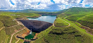
The Katse Dam, a concrete arch dam on the Malibamat'so River in Lesotho, is Africa's second largest double-curvature arch dam.. The dam is part of the Lesotho Highlands Water Project, which will eventually include five large dams in remote rural areas. The dam is just below the confluence of the Bokong River, which forms the western arm of the Katse reservoir.

Lesotho Highlands Water Project

The Lesotho Highlands Water Project (LHWP) is an ongoing water supply project with a hydropower component, developed in partnership between the governments of Lesotho and South Africa. It comprises a system of several large dams and tunnels throughout Lesotho and delivers water to the Vaal River System in South Africa. In Lesotho, it involves the rivers Malibamatso, Matsoku, Senqunyane, and Senqu. It is Africa's largest water transfer scheme.

Run-of-the-river hydroelectricity hydro power station with no or only very small reservoir for storage

Run-of-river hydroelectricity (ROR) or run-of-the-river hydroelectricity is a type of hydroelectric generation plant whereby little or no water storage is provided. Run-of-the-river power plants may have no water storage at all or a limited amount of storage, in which case the storage reservoir is referred to as pondage. A plant without pondage is subject to seasonal river flows, thus the plant will operate as an intermittent energy source. Conventional hydro uses reservoirs, which regulate water for flood control and dispatchable electrical power.

Mohale Dam dam in Lesotho

Mohale Dam is a concrete faced rock-fill dam in Lesotho. It is the second dam, under Phase 1B of the series of dams of the proposed Lesotho Highlands Water Project (LHWP), which will eventually include five large dams in remote rural areas of Lesotho and South Africa. The project has been built at a cost of US$1.5 billion.

Malibamatso River river in northern Lesotho

The Malibamat'so River is a river in northern Lesotho. Its origin is near to the South African border, where it drains the eastern slopes of the Maloti Range. It flows southwards past the village of Lejone, and eventually joins the Senqu River 5 kilometres (3.1 mi) northeast of Mohlanapeng.

Kanungu Power Station is a 6.6 megawatts (8,900 hp) run-of-the-river hydroelectric power station on the Ishasha River in Uganda. The station is sometimes referred to as the Ishasha Power Station.

Longyangxia Dam dam in Gonghe County, Qinghai Province

The Longyangxia Dam is a concrete arch-gravity dam at the entrance of the Longyangxia canyon on the Yellow River in Gonghe County, Qinghai Province, China. The dam is 178 metres (584 ft) tall and was built for the purposes of hydroelectric power generation, irrigation, ice control and flood control. The dam supports a 1,280 MW power station with 4 x 320 MW generators that can operate at a maximum capacity of 1400 MW. Controlling ice, the dam controls downstream releases to reservoirs lower in the river, allowing them to generate more power instead of mitigating ice. Water in the dam's 24.7 billion m3 reservoir provides irrigation water for up to 1,000,000 hectares of land.

Grand Ethiopian Renaissance Dam dam in Benishangul-Gumuz Region

The Grand Ethiopian Renaissance Dam, formerly known as the Millennium Dam and sometimes referred to as Hidase Dam, is a gravity dam on the Blue Nile River in Ethiopia that has been under construction since 2011. It is in the Benishangul-Gumuz Region of Ethiopia, about 15 km (9 mi) east of the border with Sudan. At 6.45 gigawatts, the dam will be the largest hydroelectric power plant in Africa when completed, as well as the 7th largest in the world. As of August 2017, the work stood at 60% completion. Once completed, the reservoir could take anywhere between 5 to 15 years to fill with water, depending on hydrologic conditions during the filling period and agreements reached between Ethiopia, Sudan and Egypt.

Jinping-I Dam dam in Yanyuan County and Muli Tibetan Autonomous County, Liangshan Prefecture, Sichuan, China

The Jinping-I Dam also known as the Jinping-I Hydropower Station or Jinping 1st Cascade, is a tall arch dam on the Jinping Bend of the Yalong River in Liangshan, Sichuan, China. Construction on the project began in 2005 and was completed in 2014. Its power station has a 3,600 MW capacity to produce between 16 and 18 TW·h annually. Supplying the power station is a reservoir created by the 305-meter-tall arch dam, the tallest in the world. The project's objective is to supply energy for expanding industrialization and urbanization, improve flood protection, and prevent erosion.

Koldam Dam dam in Bilaspur district and Mandi district

The Koldam Dam Hydropower Project commonly known as KolDam, is an embankment dam on the Satluj River upstream of the Dehar Power House. It is 18 km from Bilaspur off the Chandigarh-Manali Highway (NH-21) near Barmana, Himachal Pradesh. The main purpose of the dam is hydroelectric power generation and it will support an 800 MW power station. The dam was constructed by National Thermal Power Corporation (NTPC).

Wilge River River in Free State, South Africa, tributary of Vaal River

The Wilge River is a tributary of the Vaal River in central South Africa. This river is important as part of the Tugela-Vaal Water Transfer Scheme where water is transferred from the Tugela River basin to the Vaal River basin.

Çetin Dam

The Çetin Dam is a rock-fill dam with an asphalt-concrete core, currently being constructed on the Botan River in Siirt Province, Turkey. The dam will be located directly downstream of the Botan and Büyük River confluence and have a height of 145 m (476 ft). The primary purpose of the dam is hydroelectric power generation. The dam's power plant will house three 135 MW Francis turbine-generators. Also part of the Çetin project is a smaller dam 6 km (4 mi) downstream with 45 m (148 ft) in height. The Çetin lower dam will regulate outflows from the Çetin main dam and also produce hydroelectric power with a 112 MW capacity via two 56 MW Kaplan turbine-generators.

Broadlands Dam dam in Kitulgala

The Broadlands Dam is a 35 MW run-of-the-river hydroelectric complex currently under construction in Kitulgala, Sri Lanka. The project is expected to be completed in 2020, and will consist of two dams, and a power station further downstream.

Lom Pangar Dam dam in Bertoua

The Lom Pangar Dam is an embankment dam with a center gravity dam section currently under construction on the Lom River about 88 kilometres (55 mi) north of Bertoua in the East Region of Cameroon. It is located about 4 kilometres (2.5 mi) downstream of the Lom River's confluence with the Pangar River and about 13 kilometres (8.1 mi) upstream of where the Lom joins the Sanaga River. The purpose of the dam is to produce hydroelectric power and to regulate water flows along the Sanaga River. It is potentially part of a larger dam cascade on the Sanaga.

Golen Gol Hydropower Project dam in Chitral District of KPK , Pakistan

Golen Gol Hydropower Plant (GGHPP) is a hydroelectric power plant located on Golen Gol River - a major left tributary of Mastuj River in Chitral District of Khyber Pakhtunkhwa province of Pakistan. The dam is located approximately 25 km from Chitral city, and 365 km from provincial capital of Peshawar. Construction of Golen Gol project began in 2011, and was completed in January 2018.

References

  1. 1 2 3 4 5 Van Wyk, Francois; du Preez, Hein (2004). The environmental impact of releases from Katse Dam on the Ash and Liebenbergsvlei Rivers (PDF). WISA 2004 biennial conference and exhibition of the Water Institute of Southern Africa: Water Institute of Southern Africa. pp. 304–208. ISBN   1-920-01728-3. Archived from the original (PDF) on 24 September 2015. Retrieved 23 August 2015.
  2. "The story of Katse dam". The Highlands Journey - Lesotho. golesotho.co.za. Archived from the original on 15 February 2015. Retrieved 23 August 2015.
  3. 1 2 3 Wilkins, Blake (February 2015). "Unique contract does it for hydro delivery". Brooke Pattrick Publications. pp. 20–21. Archived from the original on 10 May 2017. Retrieved 21 August 2015.
  4. "Introduction". Bethlehem Hydro. Archived from the original on 20 October 2015. Retrieved 21 August 2015.
  5. "Stortemelk Hydropower Project, South Africa". Aurecon Projects. Retrieved 21 August 2015.