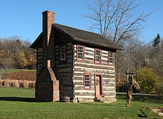
Upper St. Clair is a township with home rule status in southern Allegheny County, Pennsylvania, United States, located approximately 8 miles (13 km) south of Downtown Pittsburgh. It is known for being an affluent suburb with a nationally recognized school district. As of the 2020 census, the township population was 21,160.

Stonycreek Township is a township in Somerset County, Pennsylvania, United States. The township takes its name from the stony creek, which flows through it and represents its western boundary. The stream takes its name from the rocky bed over which it flows for a great part of its course. Its Indian name was Sinne-Hanne or Achsin-Hanne. Hanne means a stream and especially a swift mountain stream. The population was 2,087 at the 2020 census. It is part of the Johnstown, Pennsylvania, metropolitan statistical area.

McCandless is a township with home rule status in Allegheny County, Pennsylvania, United States. The population was 29,709 at the 2020 census. It is a northern suburb of the Pittsburgh metropolitan area.

Scott Township is a township in Allegheny County, Pennsylvania, United States. The population was 17,024 at the 2010 census.
A civil township is a widely used unit of local government in the United States that is subordinate to a county, most often in the northern and midwestern parts of the country. The term town is used in New England, New York, as well as Wisconsin to refer to the equivalent of the civil township in these states; Minnesota uses "town" officially but often uses it and "township" interchangeably. Specific responsibilities and the degree of autonomy vary in each state. Civil townships are distinct from survey townships, but in states that have both, the boundaries often coincide and may completely geographically subdivide a county. The U.S. Census Bureau classifies civil townships as minor civil divisions. Currently, there are 20 states with civil townships.

The Johannesburg Ring Road is a set of freeways that circle the city of Johannesburg, South Africa and service the City of Johannesburg Metropolitan Municipality. The entire ring road is approximately 83 km long and was an e-toll highway from 3 December 2013 up until e-tolls were shut down in Gauteng on 12 April 2024.

The Western Bypass is a section of the N1 and the Johannesburg Ring Road located in the city of Johannesburg, South Africa. Known at the time as the Concrete Highway, the freeway was initially opened in 1975 as a route to avoid the city centre of Johannesburg and to provide access to the western areas of the Witwatersrand. From the south, the Western Bypass begins at the Diepkloof Interchange in Soweto, where it splits from the N12 freeway and ends at the Buccleuch Interchange, where it merges with the N3 Eastern Bypass, M1 South and N1 Ben Schoeman freeways.

The N12 Southern Bypass is a section of the Johannesburg Ring Road that forms a beltway around the city of Johannesburg, South Africa, as part of the N12. The freeway was the last section of the Ring Road to be built, with the final section opening in 1986. As part of the old South African Freeways, It was initially called the N13. The entire Southern Bypass freeway was an e-toll highway from 3 December 2013 to 11 April 2024.
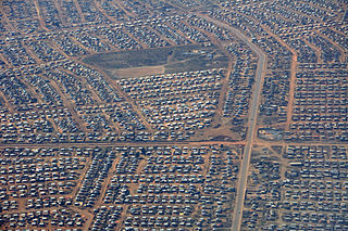
Meadowlands is a suburb of Soweto, Gauteng Province, South Africa. It was founded in the early 1950s during the apartheid era for black residents from Sophiatown.
Bosmont is a suburb of Johannesburg, South Africa. Bosmont is located in Region 4. Bosmont is located in the West Rand of Johannesburg and nearly all of its residents are Coloured.

Thokoza, alternatively rendered Tokoza, is a township in Ekurhuleni, Gauteng. Thokoza is at the location of the now-defunct Palmietfontein Airport. It is situated south east of Alberton, adjacent to Katlehong. Thokoza was the first black township which was established in the South. During the early 1990s Thokoza was the middle of unrest between the supporters of the Inkatha Freedom Party (IFP) and the African National Congress (ANC).

Metro Dayton or the Miami Valley, or more formally the Dayton–Kettering–Beavercreek, OH Metropolitan Statistical Area, as defined by the United States Census Bureau, is an area consisting of three counties in the Miami Valley region of Ohio and is anchored by the city of Dayton. As of 2020, it is the fourth-largest metropolitan area in Ohio and the 73rd-largest metropolitan area by population in the United States with a population of 814,049.

A canteen is a reusable drinking water bottle designed to be used by hikers, campers, soldiers, bush firefighters, and workers in the field. It is usually fitted with a shoulder strap or means for fastening it to a belt, and may be covered with a cloth bag and padding to protect the bottle and insulate the contents. If the padding is soaked with water, evaporative cooling can help keep the contents of the bottle cool. Many canteens also include a nested canteen cup.

Diepkloof Rock Shelter is a rock shelter in Western Cape, South Africa in which has been found some of the earliest evidence of the human use of symbols, in the form of patterns engraved upon ostrich eggshell water containers. These date around 60,000 years ago.

Redelinghuys is a village in the Bergrivier Local Municipality in the Western Cape province of South Africa, located about 160 kilometres (100 mi) north of Cape Town on the Verlorevlei River. The 2001 Census recorded the population as 581 people in 167 households. The village is situated on the R366 regional route between Piketberg and Elands Bay. It is served by a police station, a public library, a satellite health clinic, and two primary schools.

Bopasenatla Secondary School is a government secondary school in Diepkloof, Soweto. It was previously known as Junior Secondary School.
Noordgesig is a township in Soweto, situated at the edge of area's northernmost boundary, but within its territory. It is the first township seen on entering Soweto from the frequently used New Canada Road. Noordgesig is a Coloured township. It is colloquially called "Bulte"(meaning Hills) by its residence and neighbors, as depicted by the Mine Dumps surrounding the Township. The name "Bulte" was coined as a form of endearment by the residence for the longest time.
Maishe Maphonya (1951-2021) was a South Africa a political activist, playwright, director and poet. Maponya was born in Alexandra Township but his family was forcibly relocated to Diepkloof, Soweto in 1961.


