Sandton is an upscale commercial and residential district north of the city of Johannesburg, South Africa. It forms part of the City of Johannesburg Metropolitan Municipality. The name of the city came from the combination of two of its suburbs, Sandown and Bryanston. In 1969, Sandton was promulgated as a municipality in its own right, but lost its status as an independent city after the re-organisation of South African local governments after Apartheid ended.
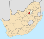
Carletonville is a town in Gauteng and the seat of the Merafong City Local Municipality in the West Rand District Municipality in Gauteng, South Africa, just north of the richest gold-mining area in the world. At 3,749 m, Western Deep Levels holds the record for the world's deepest gold mine.
Cramerview is a suburb of Johannesburg, South Africa. It is located in Region B of the City of Johannesburg Metropolitan Municipality.
Driefontein is the Driefontein Mine in the West Witwatersrand Basin mining field. The West Wits field was discovered in 1931 and commenced operations with Venterspost Gold Mine in 1939. In 1952, the West Driefontein mine is opened. In 1968, Kloof mine commences operations. In 1972, East Driefontein opens. In 1981, consolidation starts. In 1999, Gold Fields took control of the combined East and West Driefontein mines and merged them starting 2000 with Venterspost, Libanon, Leuudoorn and Kloof mines. In 2010, the current Kloof-Driefontein Complex, comprising KDC East and KDC West, is formed.
Osummit is a suburb of Johannesburg, South Africa. It is located in Region B of the City of Johannesburg Metropolitan Municipality.

Gold Fields Limited is one of the world's largest gold mining firms. Headquartered in Johannesburg, South Africa, the company is listed on both the Johannesburg Stock Exchange (JSE) and the New York Stock Exchange (NYSE). The firm was formed in 1998 with the amalgamation of the gold assets of Gold Fields of South Africa Limited and Gencor Limited. The company traces its roots back to 1887, when Cecil Rhodes founded Gold Fields of South Africa Limited. As of 2019, Gold Field was the world's eighth-largest producer of gold.
East Driefontein is a small gold mining town approximately 20 km outside Carletonville next to West Driefontein.

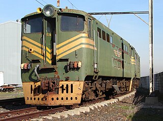
The South African Railways Class 5E, Series 2 of 1957 was an electric locomotive.
The South African Railways Class 5E, Series 3 of 1958 was an electric locomotive.

The South African Railways Class ES of 1936 was an electric locomotive.
Kensington B is a suburb in Randburg, which is an area located in northern Johannesburg, Gauteng, South Africa.
Lehurutshe is a town in Ngaka Modiri Molema District Municipality in the North West province of South Africa. The town has within its vicinity the Lehurutshe campus of Taletso TVET, a fire station and numerous schools.
Driefontein, also known as Saul Mkhizeville is a village in Gert Sibande District Municipality in the Mpumalanga province of South Africa. It has changed its name to Mkhizeville after Saul Mkhize who was shot and killed by the apartheid police for organising a march against forceful removals.

The Driefontein mine is a large mine located in the northern part of South Africa in Gauteng. Driefontein is an important gold producer and represents one of the largest uranium reserves in South Africa having estimated reserves of 238 million tonnes of ore grading 0.0053% uranium.
The KDC mine, formerly the Kloof mine, is a large mine located in the northern part of South Africa in Gauteng, near Carletonville, and represents one of the largest uranium reserves in South Africa having estimated reserves of 256.4 million tonnes of ore grading 0.0036% uranium.
Driefontein is a town in Ngaka Modiri Molema District Municipality in the North West province of South Africa.
Driefontein may refer to:

Krugersdorp Commando or Kommando was a light infantry regiment of the South African Army. It was active as a part of the South African Army Infantry Formation as well as the South African Territorial Reserve.
Chirumhanzu District is a Second-order Administrative Sub-division of Midlands (Zimbabwe) between Gweru and Masvingo.