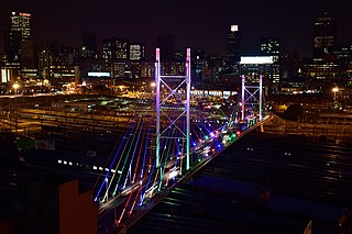
Johannesburg is the most populous city in South Africa with 4,803,262 people, and is classified as a megacity; it is one of the 100 largest urban areas in the world. It is the provincial capital of Gauteng, the wealthiest province in South Africa. Johannesburg is the seat of the Constitutional Court, the highest court in South Africa. Most of the major South African companies and banks have their head offices in Johannesburg. The city is located within the mineral-rich Witwatersrand hills, the epicentre of the international-scale mineral, gold and (specifically) diamond trade.

The Witwatersrand Gold Rush was a gold rush that began in 1886 and led to the establishment of Johannesburg, South Africa. It was a part of the Mineral Revolution.
Brakpan is a mining town on the East Rand of Gauteng, South Africa, approximately 38 kilometres east of Johannesburg.
Heriotdale is a suburb of Johannesburg, South Africa. The suburb lying south of Malvern and north of Rosherville, is an industrial area. It is located in Region F of the City of Johannesburg Metropolitan Municipality.
La Rochelle is a suburb of Johannesburg, South Africa. South of the Johannesburg CBD, the suburbs of Turffontein and Rosettenville lie to its south. It is located in Region F of the City of Johannesburg Metropolitan Municipality.
Ophirton is a suburb of Johannesburg, South Africa. This industrial suburb lies three kilometers to south-west of the Johannesburg CBD. It is located in Region F of the City of Johannesburg Metropolitan Municipality, adjacent to Booysens.
Selby is a suburb of Johannesburg, South Africa. It is located in Region F of the City of Johannesburg Metropolitan Municipality.
Theta is a suburb of Johannesburg, South Africa. It lies south-west of the Johannesburg CBD and is adjacent to Booysens Reserve. The suburb was originally developed for science, industrial and research businesses. It is located in Region F of the City of Johannesburg Metropolitan Municipality.
City and Suburban is a suburb of Johannesburg, South Africa, just east of the city centre. It is a relatively small residential and business area, inhabited by 2 703 (99,4%) an overwhelming Black majority, according to the 2011-census. It is located in Region F of the City of Johannesburg Metropolitan Municipality.
Ferreirasdorp is an inner-city suburb of Johannesburg, South Africa located in Region F of the City of Johannesburg Metropolitan Municipality.
Malvern is a suburb of Johannesburg, South Africa. Situated east of the Johannesburg CBD, it lies south of Kensington and north of the industrial suburb of Denver. It is located in Region F of the City of Johannesburg Metropolitan Municipality and lies just west of Bedfordview in the City of Ekurhuleni Metropolitan Municipality.
Salisbury Claims is a suburb of Johannesburg, South Africa. It is located in Region F of the City of Johannesburg Metropolitan Municipality.
Troyeville is a suburb of Johannesburg, South Africa. It is a small suburb found on the eastern edge of the Johannesburg CBD, with the suburbs of New Doornfontein, Bertrams and Lorentzville to the north, Fairview to the south and Kensington to its east. The main road through the suburb is Albertina Sisulu Road, which connects the CBD to Johannesburg's eastern suburbs and towns of the East Rand. It is located in Region F of the City of Johannesburg Metropolitan Municipality.

Harmony Gold is the largest gold mining company in South Africa. Harmony operates in South Africa and in Papua New Guinea. The company has nine underground mines, one open-pit mine and several surface operations in South Africa. In Papua New Guinea, it has Hidden Valley, an open-pit gold and silver mine and a 50% interest in the Morobe Mining Joint Venture, which includes the Wafi-Golpu project and extensive exploration tenements. Outside the joint venture, Harmony's own exploration portfolio focuses principally on highly prospective areas in Papua New Guinea.
Emmarentia is a suburb of Johannesburg, South Africa.
Greenside, is a suburb of Johannesburg, South Africa. Greenside borders on the suburbs Emmarentia, Parkview, Parkhurst and Victory Park.
Blyvooruitzicht is a gold mine and gold-mining village in Gauteng, South Africa. It is situated about 5 kilometres (3.1 mi) south of the centre of Carletonville and 80 kilometres (50 mi) westwards from Johannesburg.

The Johannesburg Botanical Garden is located in the suburb of Emmarentia in Johannesburg, South Africa. The gardens grew out of a large rose garden that was established in 1964 and subsequently expanded from 1969 to cover an area of around 125 hectares (1.25 km2). It is administered by Johannesburg City Parks. The Emmarentia Dam is situated immediately to the east of the garden and shares its extensive acreage. One of the main attractions is the Rose Garden with over 10 000 roses.
The M17 is a metropolitan route in Johannesburg, South Africa. It runs north from the southern suburb of Ridgeway through Mayfair a suburb just west of the Johannesburg Central Business District and ends in the north in Auckland Park. It intersect two main Johannesburg freeways, starting with an intersection to the N12 Southern Bypass and the north–south M1 freeway.
Parlshoop is a suburb of Johannesburg, South Africa, around 4 km west of City Hall. It borders Langlaagte to the north and Homestead Park to the northeast. The name comes from the village of Paarlshoop, the oldest private township on the Witwatersrand.

