Rand Water

Last updated
Rand Water
FormerlyRand Water Board
IndustryWater Utility
Founded8 May 1903;120 years ago (1903-05-08) in Johannesburg, South Africa
Headquarters
Glenvista, Gauteng
,
South Africa
Key people
Matshidiso Hashatse (Chairperson)
Sipho Mosai (CEO)
ProductsBulk potable water
ServicesInfrastructure and storage system management, water purification, bulk sanitation, water quality management, and water analysis
Website www.randwater.co.za

Rand Water (previously known as the Rand Water Board) is a South African water utility that supplies potable water to the Gauteng province and other areas of the country and is the largest water utility in Africa. The water is drawn from numerous sources and is purified and supplied to industry, mining and local municipalities and is also involved in sanitation of waste water.

Contents

History

The Witwatersrand sits on the South African Highveld and consists of mostly grasslands with summer rains with an average yearly of 784mm rainfall. [1] :210 The Witwatersrand ridge stretches for 96 km from east to west with rivers north of the ridge flowing to north into the Limpopo and into the Indian Ocean while the rivers south of the ridge flow south into the Vaal and Orange River and into the Atlantic Ocean. [1] :210 The rivers in the Witwatersrand tended to dry out in the winter and were therefore a poor source of water and semiarid with grasslands and soil more suitable for cattle and sheep farming prior to the discovery of gold. [1] :210

Gold was discovered on the Witwatersrand during March 1886 and several communities would rapidly develop from tents, to villages, towns and eventually into a city called Johannesburg. [1] :213 Being on the watershed of two river systems, the area was always short of water for the growing industry and community. [1] :214 After the Second Anglo-Boer War (1899–1902), the British government took control of the Transvaal Colony and with the need to restore gold mining to pre-war levels. The Transvaal administration decided to centralise the management of water resources on the Witwatersrand and the Rand Water Board was formed on 8 May 1903 with the enactment of Rand Water Board Incorporation Ordinance No. 32. [1] :217 [2]

The Board would be made up of eleven members recommended by the Governor of the Transvaal Colony, the Johannesburg Town Council, the Chamber of Mines and other municipalities at the time and would amalgamate all other companies currently supply water to that point. [2] [3] :416 The initial eleven members consisted of five members from the Chamber of Mines, three from the Johannesburg municipality, one from Germiston/Boksburg, one from Springs and one from Krugersdorp/Roodepoort. [4] :56 It would commence operations in 1905. [2] Later membership increased to 34 as Benoni joined in 1906, the Railways in 1914, Brakpan in 1920, Randfontein in 1929, Nigel in 1935 and Pretoria and Vereeniging in 1944. [4] :56

Water sources

Initial water sources for the growing town of Johannesburg were obtained from three spruits or streams, one at a spruit in Fordsburg which still runs at the western end of Commissioner Street, a stream called Natalspruit at the eastern end of Commissioner Street near Jeppestown and a spring on Parktown ridge where Johannesburg General Hospital stands. [2] [4] :52

As mining and town expanded so demand grew and two organisations formed to supply water. Braamfontein Water Company with two wells in the Parktown region supplied the town and Vierfontein Syndicate that supplied mining and drinking water while the first grant to supply water came via the Sivewright Concession of 1887 that established the Johannesburg Waterworks and Exploration Company. [2] James Sivewright was granted the concession by the South African Republic (ZAR) to supply water to the town of Johannesburg but the concession did not oblige his company to supply it. [4] :52 By 1889, Sivewright had sold his concession to Johannesburg Waterworks, Estate and Exploration Company Limited, that was owned by Barney Barnato. [4] :52

The company then built a dam at a site in present-day Doornfontein where the Ellis Park Stadium is now positioned and then pumped the water to a reservoir on the ridge above Saratoga Avenue on the corner of Harrow Road and this gravity fed supply was said to have provided 3,409,569L during the rainy season. [4] :53 The population of the town, run at that time by a Sanitary Board, was petitioned in 1892 concerning the lack of adequate water supply and its cost, 15s per gallon and 5s per month for metering. [4] :53 The Johannesburg Waterworks Company was said to be supplying 4,091,400L a day by 1895 but had to use mules and carts to transport water to the higher parts of the town during a drought that year and all water still had to be boiled before use. [4] :53

The ZAR government appointed a commission of enquiry in the same year to investigate the future of water supply and its quality. [4] :54 The commission handed down a recommendation that the management of water supply should be held by a public authority but this had not occurred before war broke out in 1899, the Second Boer War. [4] :54 In 1898, the Johannesburg Waterworks Company sunk boreholes on the farm Zuurbekom (on the outskirts of Lenasia; 26°18′04″S27°48′49″E / 26.30104°S 27.81350°E / -26.30104; 27.81350 ), under which was a natural aquifer of 466sq km that would eventually produce 34,09,5000L a day. [4] :54 In 1899, the Zuurbekom Pumphouse was erected by the Johannesburg Exploration and Estate Company and is still operational. Its purpose was to extract and provide the water from the dolomite rocks under the vast wetland to Central Witwatersrand. [5] In 1975, it was declared a National Monument, and subsequently made into a Provincial Heritage Site in 2000. [6]

By 1901, the British forces were in control of Johannesburg, though the war continued elsewhere, and the idea of a public body to control water supply was resurrected with the formation of a municipal council and by November a commission of enquiry was formed. [4] :55 The Witwatersrand Water Supply Commission was formed on 4 November 1901 and after three months recommended the formation of the public Rand Water Board to supply water to the towns and mines of the Witwatersrand from Springs in the east and Randfontein in the west. [4] :55

With the creation of the Rand Water Board, bore holes were driven into river bed of the Klip River but by 1914, the Board decided to build a barrage on the Vaal River 64 km to the south of Johannesburg with the Vereeniging Pumping Station which was opened on 27 July 1923 by the Governor-General. [1] :217 [2] [4] :56 Water was pumped through 137 cm pipes from the barrage at 1,432m to a height of 1828m on the Witwatersrand. [4] :56 More water was still required and by 1937 the Vaal Dam was completed 80 km south-east of Johannesburg. [1] :217 [2]

The next major project was the Lesotho Highlands Water Project in 1998 that saw the construction of several large dams and pipeline transporting water from Lesotho to the Vaal Dam in South Africa. [2]

Supply system

Rand Water provides potable water to metropolitan and local municipalities, industry and mining in Gauteng, and parts of Mpumalanga, the Free State, and North West provinces. [7] Rand Water has water network of 3,056 km of pipelines, 58 reservoirs, supplying 3 653 million litres of water daily to its varied customers. [2] Its headquarters is in the suburb of Glenvista. [7]

Related Research Articles

<span class="mw-page-title-main">Vaal River</span> Tributary of the Orange River, South Africa

The Vaal River is the largest tributary of the Orange River in South Africa. The river has its source near Breyten in Mpumalanga province, east of Johannesburg and about 30 kilometres (19 mi) north of Ermelo and only about 240 kilometres (150 mi) from the Indian Ocean. It then flows westwards to its confluence with the Orange River southwest of Kimberley in the Northern Cape. It is 1,458 kilometres (906 mi) long, and forms the border between Mpumalanga, Gauteng and North West Province on its north bank, and the Free State on its south.

<span class="mw-page-title-main">Transvaal (province)</span> Former province of South Africa

The Province of the Transvaal, commonly referred to as the Transvaal, was a province of South Africa from 1910 until 1994, when a new constitution subdivided it following the end of apartheid. The name "Transvaal" refers to the province's geographical location to the north of the Vaal River. Its capital was Pretoria, which was also the country's executive capital.

<span class="mw-page-title-main">Witwatersrand</span> Ridge of erosion resistant rock in South Africa

The Witwatersrand is a 56-kilometre-long (35 mi), north-facing scarp in South Africa. It consists of a hard, erosion-resistant quartzite metamorphic rock, over which several north-flowing rivers form waterfalls, which account for the name Witwatersrand, meaning "white water ridge" in Afrikaans. This east-west-running scarp can be traced with only one short gap, from Bedfordview in the east, through Johannesburg and Roodepoort, to Krugersdorp in the west.

<span class="mw-page-title-main">Gauteng</span> Province in South Africa

Gauteng is one of the nine provinces of South Africa.

<span class="mw-page-title-main">History of Johannesburg</span>

Johannesburg is a large city in Gauteng Province of South Africa. It was established as a small village controlled by a Health Committee in 1886 with the discovery of an outcrop of a gold reef on the farm Langlaagte. The population of the city grew rapidly, becoming a municipality in 1898. In 1928 it became a city making Johannesburg the largest city in South Africa. In 2002 it joined ten other municipalities to form the City of Johannesburg Metropolitan Municipality. Today, it is a centre for learning and entertainment for all of South Africa. It is also the capital city of Gauteng.

<span class="mw-page-title-main">Witwatersrand Gold Rush</span> Gold rush in Johannesburg, South Africa

The Witwatersrand Gold Rush was a gold rush that began in 1886 and led to the establishment of Johannesburg, South Africa. It was a part of the Mineral Revolution.

<span class="mw-page-title-main">Vereeniging</span> City in Gauteng, South Africa

Vereeniging is a city located in the south of Gauteng province, South Africa, situated where the Klip River empties into the northern loop of the Vaal River. It is also one of the constituent parts of the Vaal Triangle region and was formerly situated in the Transvaal province. The name Vereeniging is the Dutch word meaning "association".

<span class="mw-page-title-main">Highveld</span> Geographic region of the South African inland plateau

The Highveld is the portion of the South African inland plateau which has an altitude above roughly 1500 m, but below 2100 m, thus excluding the Lesotho mountain regions to the south-east of the Highveld. It is home to some of the country's most important commercial farming areas, as well as its largest concentration of metropolitan centres, especially the Gauteng conurbation, which accommodates one-third of South Africa's population.

Parktown is a wealthy suburb of Johannesburg, South Africa, and is the first suburb north of the inner city. It is affectionately known as one of the Parks, others including Parkview, Parkwood, Westcliff, Parktown North, Parkhurst and Forest Town. Parktown is one of Johannesburg's largest suburbs, neighbouring Hillbrow, Braamfontein and Milpark to the South; Berea and Houghton to the East; Killarney and Forest Town to the North, and Westcliff, Melville and Richmond to the West. Originally established by the Randlords in the 1890s, Parktown is now home to many businesses, hospitals, schools, churches and restaurants, whilst still maintaining quiet residential areas. It is also home to three of the five campuses of the University of the Witwatersrand including the education campus, medical school and Wits Business School. It is located in Region F of the City of Johannesburg Metropolitan Municipality.

Randlords were the capitalists who controlled the diamond and gold mining industries in South Africa from the 1870s up to World War I.

<span class="mw-page-title-main">Zoo Lake</span> Lake in Gauteng, South Africa

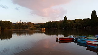
Zoo Lake is a popular lake and public park in Johannesburg, South Africa. It is part of the Hermann Eckstein Park and is opposite the Johannesburg Zoo. The Zoo Lake consists of two dams, an upper feeder dam, and a larger lower dam, both constructed in natural marshland watered by the Parktown Spruit.

<span class="mw-page-title-main">Braamfontein Spruit</span> River in Gauteng, South Africa

The Braamfontein Spruit is the longest stream in Johannesburg, South Africa.

The Vaal River Barrage Reservoir is a dam on the Vaal River near Vanderbijlpark, border Gauteng and Free State, South Africa.

<span class="mw-page-title-main">Metrorail Gauteng</span> South African commuter rail network

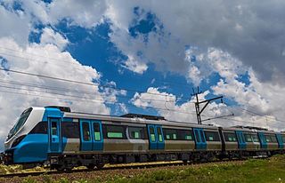
Metrorail Gauteng is a network of commuter rail services in Gauteng province in South Africa, serving the Johannesburg and Pretoria metro areas. It is operated by Metrorail, a division of the Passenger Rail Agency of South Africa (PRASA).

Jan Smuts Avenue is a major street in Johannesburg, South Africa. It begins in Randburg, and passes through important business areas like Rosebank. It passes the Johannesburg Zoo, Zoo Lake and Wits University before becoming Bertha Street, and the Nelson Mandela Bridge near the Johannesburg CBD. It has been described as "the most important road for a tourist" in Johannesburg. It forms part of Johannesburg's M27 route.

<span class="mw-page-title-main">Klip River</span> River in Gauteng, South Africa

The Klip River is the main river draining the portion of Johannesburg south of the Witwatersrand, and its basin includes the Johannesburg CBD and Soweto. The mouth of the river is at Vereeniging where it empties into the Vaal River, which is a tributary to the Orange River. Besides Vereeniging, other towns along the river include Henley on Klip, Lenasia and Meyerton.

<span class="mw-page-title-main">Yeoville Water Tower</span> Building

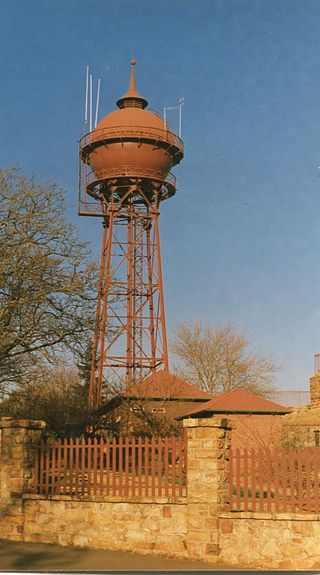
The Yeoville Water Tower is located in Harley and Percy Streets, Yeoville, near the fountain of Doornfontein; it was built in 1914 by the Sivewright's Johannesburg Waterworks, Estate and Exploration company. It was constructed with a reservoir to supply piped water to Johannesburg.

<span class="mw-page-title-main">Klipriviersberg Nature Reserve</span> Largest nature reserve in Johannesburg

Klipriviersberg Nature Reserve is a nature reserve consisting of veld and koppies (hills) run by the Johannesburg City Parks. It is located 11 kilometres (6.8 mi) south of Johannesburg, in an area of 640 hectares. Home to many species of flora and bird life, it is also home to large and small mammals such as blesbok, zebra, wildebeest and duiker. The reserve has a number of hiking trails and archaeological sites, with the Bloubosspruit flowing through the area.

Johannes Petrus Meyer was a politician, member of the Volksraad of the South African Republic, mining entrepreneur, and farmer; he is the man for whom Meyerton and Meyersdal are named.

Victoria Falls and Transvaal Power Company was a South African-based electricity company that supplied power to the goldmines and industry on the Witwatersrand. It was a Southern Rhodesian registered company whose main facilities were based in the Transvaal, South Africa. It was formed in 1906 and would supply power in its own name and on behalf of Eskom until 1948 when it was expropriated by the former.

References

  1. 1 2 3 4 5 6 7 8 Petterson, Donald R. (July 1951). "The Witwatersrand a Unique Gold Mining Community". Economic Geography. 27 (3): 209–221. JSTOR   141095.
  2. 1 2 3 4 5 6 7 8 9 "Rand Water". Rand Water. Retrieved 24 May 2015.
  3. Manson, Edward; Bisschop, W.R (1905). "South Africa". Journal of the Society of Comparative Legislation. 6 (1): 391–417. JSTOR   752054.
  4. 1 2 3 4 5 6 7 8 9 10 11 12 13 14 15 Leyds, Gerald Anton (1964). A History of Johannesburg: The Early Years. Nasional Boekhandel. p. 318.
  5. McCarthy, T. S.; Arnold, V.; Venter, J.; W. N., Ellery (2007-09-01). "The collapse of Johannesburg's Klip River wetland" (PDF). South African Journal of Science: 391–397. Archived from the original (PDF) on 2022-06-15 via Academy of Science of South Africa.
  6. "9/2/262/0013 | SAHRA". SAHRA . Retrieved 2023-07-11.
  7. 1 2 "Rand Water". Bloomberg Business. Retrieved 24 May 2015.