Thembisa

Last updated
Thembisa
Tembisa
Lazarus Mawela Station-Tembisa.png
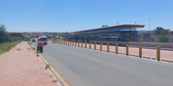
Lazarus Mawela Station in Thembisa township
South Africa Gauteng location map.svg
Red pog.svg
Thembisa
South Africa adm location map.svg
Red pog.svg
Thembisa
Africa location map.svg
Red pog.svg
Thembisa
Coordinates: 26°00′20″S28°12′37″E / 26.0055°S 28.2102°E / -26.0055; 28.2102
CountrySouth Africa
Province Gauteng
Municipality Ekurhuleni
Established1957
  Councillor(ANC)
Area
[1]
  Total42.80 km2 (16.53 sq mi)
Population
 (2011) [1]
  Total463,109
  Density11,000/km2 (28,000/sq mi)
Racial makeup (2011)
[1]
   Black African 98.9%
   Coloured 0.2%
   Indian/Asian 0.1%
   White 0.1%
  Other0.7%
First languages (2011)
[1]
   Northern Sotho 33.1%
   Zulu 21.7%
   Tsonga 13.3%
   Xhosa 7.0%
  Other24.9%
Time zone UTC+2 (SAST)
Postal code (street)
1632
PO box
1628
Area code 011

Thembisa, formerly Tembisa, [2] is a large township situated to the north of Kempton Park on the East Rand, Gauteng, South Africa. It was established in 1957 when black people were resettled from Alexandra and other areas in Edenvale, Kempton Park, Midrand and Germiston.

Contents

History

The township was formed in 1957, under the administration of the Germiston city council which oversaw the forced relocation of black people from locations deemed to be in white areas, such as Dindela, Tikkieline, Phelindaba, and Modderfontein which spanned Edenvale, Modderfontein and Kempton Park. [3] It is the second largest township in Gauteng, following Soweto. [4]

In 1977 the government initiated the Community Councils and in 1982 upgraded them to Town Councils, under the Black Local Authorities Act. The government vested limited powers on these councils but without financial muscle. Therefore, to raise revenue for purposes of developing the townships, the councils increased rent and service charges. This caused the residents in different townships, including Thembisa, to establish civic structures to resist the rent and service charge increases. [5]

On 26 July 2016, residents were caught off guard when a tornado hit the area. The twister started in Kempton Park and moved over to Thembisa. Around 20 individuals were seriously injured and in excess of 400 were left destitute. A standout amongst the most noticeable sights was the damage caused to the Phumulani Mall, where the rooftop crumbled after the tornado passed through it. [6]

Transport

Road

Thembisa is connected to Pretoria in the north and Kempton Park in the south via two main roads, namely the M57 Metropolitan Route and the R21 Highway, both bypassing Thembisa to the east.

The northern part of Thembisa is connected to Midrand in the west by the R562 Route (Winnie Madikizela-Mandela Road). The R562 forms the boundary between Thembisa and Olifantsfontein (Clayville).

The main route through the Thembisa town centre is the M18 Route, which is formed by two roads (Andrew Mapheto Drive and Reverend RTJ Namane Drive). It connects Thembisa with Olifantsfontein and Centurion in the north and with Chloorkop (near Kempton Park West) in the south-west. [5]

Rail

The main Metrorail route between Pretoria in the north and Johannesburg via Germiston in the south has a station in Thembisa east, namely the Oakmoor station. Just south of the Oakmoor station is a branch rail which heads north-west into the township, with the stations on the branch rail being Thembisa in the east, Limindlela in the center and Leralla in the west. [2]

Notable people

Related Research Articles

<span class="mw-page-title-main">Midrand</span> Place in Gauteng, South Africa

Midrand is a former municipality in central Gauteng, South Africa. Situated in-between Centurion and Sandton, Midrand now forms part of the City of Johannesburg Metropolitan Municipality.

<span class="mw-page-title-main">East Rand</span> Eastern region of Gauteng, South Africa

The East Rand is a major urban area located in the Gauteng province of South Africa. It is the urban eastern part of Witwatersrand that is functionally merged with the Johannesburg conurbation. The region extends from Alberton in the west to Springs in the east, and south down to Nigel. It includes the towns of Bedfordview, Benoni, Boksburg, Brakpan, Edenvale, Germiston, Kempton Park, Linksfield and Modderfontein. The East Rand is known as the transport hub of Johannesburg and includes Africa's largest and second busiest airport, OR Tambo International Airport.

<span class="mw-page-title-main">Greater Johannesburg</span> Metropolitan conurbation in Gauteng, South Africa

The term Greater Johannesburg may refer to:

<span class="mw-page-title-main">Former Region 7 (Johannesburg)</span>

Region 7 was an administrative district in the City of Johannesburg, South Africa, from 2000 to 2006. It included the densely populated Alexandra township and the town of Modderfontein and was one of Johannesburg's eastern boundary sections, situated in the north-east of the city. Regions 2 (Midrand), 3 (Sandton), and 8 (Central) were to its west, with Midrand also forming its northern boundary. It touched on Region 9 in the south. Its position gives it good access to the City's eastern neighbours, such as Kempton Park and Germiston. The region was abolished with a reorganisation of regions in 2006.

<span class="mw-page-title-main">Edenvale, South Africa</span> Place in Gauteng, South Africa

Edenvale is a small city on the East Rand in Gauteng, South Africa. The greater Edenvale area has an estimated population of 70,000, including Greenstone, Harmelia, Highway Gardens, Buurendal and Croydon. Edenvale is part of the Ekurhuleni Metropolitan Municipality. It lies about halfway between the O.R. Tambo International Airport and the Johannesburg city centre and is located 12 km by road from Sandton and about 9 km from the closest Gautrain station.

<span class="mw-page-title-main">Kempton Park, South Africa</span> Place in Gauteng, South Africa Postal address 1619

Kempton Park is a city in the East Rand region of Gauteng province, South Africa. It is part of the City of Ekurhuleni Metropolitan Municipality. It is situated south of Thembisa, one of the largest townships in South Africa, which is also part of Ekurhuleni. South Africa's busiest airport, O. R. Tambo International Airport is located in Kempton Park.

<span class="mw-page-title-main">Bedfordview</span> Place in Gauteng, South Africa

Bedfordview is an affluent suburb in western Ekurhuleni, sharing an administrative boundary with the City of Johannesburg Metropolitan Municipality, Gauteng, South Africa. Bedfordview has been part of the City of Ekurhuleni Metropolitan Municipality since 2000. The Eastgate Shopping Centre, one of the biggest in Africa when first built, is also located here.

<span class="mw-page-title-main">R21 (South Africa)</span> Road in South Africa

The R21 is a major north–south provincial route in eastern Gauteng Province, South Africa. Built in the early 1970s, it remains one of two freeways linking Pretoria with Johannesburg, via the R24. As the eastern of the two freeways, it links the Pretoria city centre with OR Tambo International Airport and Boksburg. Between the Solomon Mahlangu Drive on-ramp in Monument Park, Pretoria, and the N12 interchange in Boksburg, the R21 is an 8 lane highway and motorway (freeway), with 4 lanes in each direction. It has off-ramps leading to Irene, Olifantsfontein, Benoni, and Kempton Park. The route intersects the N1 highway near Centurion, the R24 near the airport, the N12 and N17 in Boksburg, and the N3 near Vosloorus on the East Rand, where it ends. The section from the N12 to the N3 is not a freeway. The R21 is also designated as the P157.

<span class="mw-page-title-main">R25 (South Africa)</span> Road in South Africa

The R25 is a provincial route in South Africa that connects Johannesburg with Groblersdal via Kempton Park, Bapsfontein and Bronkhorstspruit.

<span class="mw-page-title-main">Hennops River</span> River in South Africa

The Hennops River is one of the larger rivers that drains Gauteng, South Africa. It has its source near Kempton Park, east of Johannesburg and meets the Crocodile River shortly before Hartbeespoort Dam. It is one of Gauteng's most polluted rivers.

<span class="mw-page-title-main">Metrorail Gauteng</span> South African commuter rail network

Metrorail Gauteng is a network of commuter rail services in Gauteng province in South Africa, serving the Johannesburg and Pretoria metro areas. It is operated by Metrorail, a division of the Passenger Rail Agency of South Africa (PRASA).

The R562 is a Regional Route in Gauteng, South Africa that connects Diepsloot with Olifantsfontein (Clayville) and Thembisa via Midrand.

The 2016 Johannesburg flood was a natural disaster in South Africa that took place on 9 November 2016. The flooding, which occurred in the area east of Johannesburg, affected both Johannesburg and Ekurhuleni. The storm and flash floods caused significant damage to the township of Alexandra, while the suburb of Buccleuch was declared a disaster area. The flooding was caused by a significant cloud burst from a convective system.

Taal-Net Group of Schools is consortium of co-educational, selective day and boarding schools which encompasses pre-schools, primary schools, secondary schools, and Further Education and Training Colleges. The schools are situated in South Africa and Zimbabwe. The schools are registered with Department of Education in South Africa, UMALUSI, Department of High Education in South Africa and Ministry of Education and Child Welfare in Zimbabwe.

The M57 is a major metropolitan route in Greater Johannesburg, South Africa. A north/south route, it connects Germiston with the south-eastern suburbs of Pretoria via Kempton Park and Olifantsfontein. For most of its length, it is an alternative route to the R21 freeway.

The M38 is a short metropolitan route in Johannesburg, South Africa. The entire route is in the Johannesburg South area, connecting Southgate with Tulisa Park via Ridgeway. It is parallel to the Johannesburg Southern Bypass for its entire route.

The M39 is a long metropolitan route in Greater Johannesburg, South Africa. It connects Kyalami with Germiston via Midrand, Kempton Park & Isando.

Olifantsfontein, also known as Clayville, is a small town on the East Rand in the Gauteng Province of South Africa. It is located at the north-western corner of the City of Ekurhuleni Metropolitan Municipality, just north of the Thembisa township. As of the 2011 Census, the town has a population of 14,526 people.

The M18 road is a long metropolitan route in Gauteng, South Africa. It connects Pretoria with Thembisa via Centurion and Olifantsfontein.

References

  1. 1 2 3 4 "Main Place Tembisa". Census 2011.
  2. 1 2 Mbuli, Mbekezeli (13 February 2020). "Tembisa to get missing 'h' back after years of misspelling". The Citizen. Retrieved 2020-09-04.
  3. "SAHA - South African History Archive - Tembisa: Locations before Tembisa - pre-1957". www.saha.org.za. Retrieved 2023-01-04.
  4. "These are the biggest townships in South Africa". BusinessTech. 14 August 2016. Retrieved 27 February 2024.
  5. 1 2 "SAHA - South African History Archive - Tembisa in the 1980s - Civic structures". www.saha.org.za. Retrieved 2018-05-03.
  6. "Roof of Tembisa mall collapses after tornado rips through area". TimesLIVE. 26 July 2016. Retrieved 23 December 2021.