Hartsdale is a hamlet located in the town of Greenburgh, Westchester County, New York, United States. The population was 5,293 at the 2010 census. It is a suburb of New York City.

Sandton is a financial, commercial and residential area, located in the northern part of the City of Johannesburg Metropolitan Municipality. Formerly an independent municipality, Sandton's name came from the combination of two of its suburbs, Sandown and Bryanston.
Laudium is an Indian township southwest of central Pretoria, in the City of Tshwane Metropolitan Municipality. Claudius is a residential suburb that is effectively an extension of Laudium.

Midrand is a town in central Gauteng, South Africa. It is situated in-between Centurion and Sandton. Formerly an independent municipality, Midrand now forms part of the City of Johannesburg Metropolitan Municipality.

The N1 is a national route in South Africa that runs from Cape Town through Bloemfontein, Johannesburg, Pretoria and Polokwane to Beit Bridge on the border with Zimbabwe. It forms the first section of the famed Cape to Cairo Road.

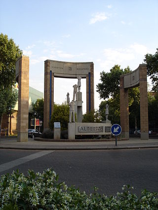
Alberton is a town situated on the southern part of the East Rand of the Gauteng Province in South Africa and is situated very close to the major urban centre of Johannesburg.

Bedfordview is an affluent suburb in western Ekurhuleni, sharing an administrative boundary with the City of Johannesburg Metropolitan Municipality, Gauteng, South Africa. Bedfordview has been part of the City of Ekurhuleni Metropolitan Municipality since 2000. The Eastgate Shopping Centre, one of the biggest in Africa when first built, is also located here.

The R25 is a provincial route in South Africa that connects Johannesburg with Groblersdal via Kempton Park, Bapsfontein and Bronkhorstspruit.

The R55 is a north-south provincial route in Gauteng, South Africa that connects Sandton with Pretoria. It passes Woodmead, Kyalami, Olievenhoutbosch, Heuweloord, Sunderland Ridge, Erasmia, Laudium/Claudius, West Park, the Daspoort Tunnel and Danville. It connects with the M1, N14, and R80 highways. It is also designated as the P66-1 and K71 by the Gauteng Provincial Government.

Marshalltown is a suburb of Johannesburg, South Africa. It is located in Region F of the City of Johannesburg Metropolitan Municipality.

The Jukskei River is one of the largest rivers in Johannesburg, South Africa. It is the southernmost river in the Crocodile River basin.
Louis Botha Avenue is a major street in Johannesburg, South Africa. Originally part of the main road between central Johannesburg and Pretoria, it runs along through the north-eastern parts of the city from Hillbrow to Sandton, passing through numerous older suburbs, including Houghton and Orange Grove, before it becomes the Pretoria Main Road (R101) which passes the Alexandra Township and continues to Midrand and Pretoria.
Randpark Ridge is an upmarket suburb of Randburg, South Africa. It is located in Region C of the City of Johannesburg. It fell into the town of Randburg during the apartheid era. Developed in the early 1980s and still relatively new, Randpark Ridge is bordered by several other suburbs including Weltevreden Park, Sundowner, Boskruin, Bromhof, Honeydew and Fairland.
Eersterust or "First Rest", often incorrectly spelled "Eersterus", is a formal South African township within the City of Tshwane Metropolitan Municipality and is located just about 15 km east of the Pretoria city centre. It is also referred to by locals as "Poort". Eersterust is situated west of Mamelodi.
Kensington B is a suburb in Randburg, which is an area located in northern Johannesburg, Gauteng, South Africa.

The Ben Schoeman Freeway or Ben Schoeman Highway is the main freeway between Johannesburg and Pretoria, and consists of portions of the M1, N1, and N14. Opened in 1968, it is named after former Minister of Transport Ben Schoeman, and is undoubtedly the busiest road in South Africa.
The R564 is a Regional Route in the City of Johannesburg Metropolitan Municipality in Gauteng, South Africa. It connects Roodepoort with Buccleuch via Northriding and Fourways.

The Klip River is the main river draining the portion of Johannesburg south of the Witwatersrand, and its basin includes the Johannesburg CBD and Soweto. The mouth of the river is at Vereeniging where it empties into the Vaal River, which is a tributary to the Orange River. Besides Vereeniging, other towns along the river include Henley on Klip, Lenasia and Meyerton.
The 2016 Johannesburg flood was a natural disaster in South Africa that took place on 9 November 2016. The flooding, which occurred in the area east of Johannesburg, affected both Johannesburg and Ekurhuleni. The storm and flash floods caused significant damage to the township of Alexandra, while the suburb of Buccleuch was declared a disaster area. The flooding was caused by a significant cloud burst from a convective system.
The M40 is a metropolitan route in Greater Johannesburg, South Africa that connects Sandton with Bedfordview via Wynberg, Kew, Lyndhurst and Senderwood.


