Sub-Saharan Africa is, geographically, the area and regions of the continent of Africa that lies south of the Sahara. These include West Africa, East Africa, Central Africa, and Southern Africa. Geopolitically, in addition to the African countries and territories that are situated fully in that specified region, the term may also include polities that only have part of their territory located in that region, per the definition of the United Nations (UN). This is considered a non-standardized geographical region with the number of countries included varying from 46 to 48 depending on the organization describing the region. The African Union uses a different regional breakdown, recognizing all 55 member states on the continent - grouping them into 5 distinct and standard regions.
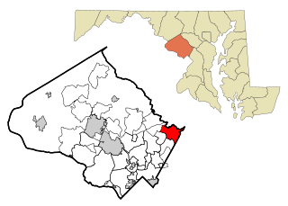
Burtonsville is a census-designated place and an unincorporated area in Montgomery County, Maryland, United States. It is situated in the northeast corner of Montgomery County, right on the border of both Howard and Prince George's counties. It is considered a suburban town in the Washington D.C. Metro Area.

Buena Vista is an unincorporated community within Buena Vista Charter Township, Saginaw County in the U.S. state of Michigan. The U.S. Census Bureau has defined a census-designated place (CDP) with the same name for statistical purposes. The CDP has no official status as a municipality and the boundaries defined by the Census Bureau may not precisely correspond to local understanding of the Buena Vista area. The CDP consists of an area adjacent to the city of Saginaw on its east side and mostly east of Interstate 75. The population was 7,845 at the 2000 census.
Morrisville is a village in Madison County, New York, United States. The population was 2,199 at the 2010 census. The village is named after its founder, Thomas Morris.
Rossiter is a Census-designated place (CDP) in Indiana County, Pennsylvania, United States. The population was 646 at the 2010 census.
Tyler Run-Queens Gate was a census-designated place (CDP) in York County, Pennsylvania, United States. The population was 2,926 at the 2000 census. The area was redelineated as two separate CDPs, Tyler Run and Queens Gate, for the 2010 census.

Hebron is a town in Denton County in the U.S. state of Texas with a small disconnected section in Collin County. The population was 415 at the 2010 census.

Washingtonville is a village in northern Columbiana and southern Mahoning counties in the U.S. state of Ohio. The population was 712 at the 2020 census. Southern Washingtonville is included in the Salem micropolitan area, while northern Washingtonville is part of the Youngstown–Warren metropolitan area.
Wynberg is a suburb of Johannesburg, South Africa. It is located in Johannesburg's Region E of the City of Johannesburg Metropolitan Municipality. It has been called Johannesburg's worst named suburb, as it is not a leafy, vine covered enclave with a mountain view, but rather a built-up area with wall-to-wall factories.
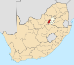
Lindley is a small town situated on the banks of the Vals River in the eastern region of the Free State province of South Africa. It was named after an American missionary, Daniel Lindley, who was the first ordained minister to the Voortrekkers in Natal.

Petrus Steyn, is a small farming town between Tweeling and Kroonstad, 35 km north-east of Lindley in the Free State province of South Africa. It is at the centre of an agricultural area known for wheat, maize, sunflower, potato, cattle, hunting, sheep production and forms part of the breadbasket in the Free State. It is the highest town above sea level in the Free State.
Sandown is an affluent suburb of Johannesburg, South Africa, in Sandton. It is located in Region E of the City of Johannesburg Metropolitan Municipality. Sandown is both a residential and commercial area and is home to the offices of many major national and international corporations as well as the Johannesburg Stock Exchange in the area known as Sandton Central. The Gautrain rapid rail system's Sandton Station is located in Sandown, linking Sandton to O.R. Tambo International Airport, Johannesburg Central and the Capital City, Pretoria.
Gulshan-e-Ghazi is a neighbourhood in the Karachi West district of Karachi, Pakistan, that previously was a part of Baldia Town until 2011.

Tagus is a ghost town in Mountrail County, North Dakota, United States. The town was founded in 1900, approximately forty miles west of Minot and along the Great Northern Railway's transcontinental route. It incorporated in 1908 and reached a peak population of 140 in 1940. It was originally named Wallace, but was later renamed Tagus to avoid confusion with the town of Wallace, Idaho.
Şıxbabalı is a village in the Agdam Rayon of Azerbaijan.

Oeceoclades, collectively known as the monk orchids, is a genus of flowering plants from the orchid family, Orchidaceae. It is related to Eulophia and like that genus is mostly terrestrial in habit. A few species extend into very arid environments, unusual for an orchid.
Millersburg is an unincorporated community in Callaway County, in the U.S. state of Missouri. It is located near the Boone-Callaway county line on the Owl Creek tributary of Cedar Creek. The Little Dixie Lake and Little Dixie Wildlife Management Area lie on Owl Creek just north of the community. It is on Missouri Route J about four miles south of I-70.
Wolf Creek is a stream in Phelps County in the Ozarks of Missouri. It is a tributary of Beaver Creek.

Robinsons Place Valencia is a three level full-service shopping mall located in Valencia City, Bukidnon. The mall opened on December 12, 2018. Robinsons Place Valencia is the first national brand mall in the province of Bukidnon, the 51st Robinsons mall in the country and the seventh Robinsons mall in Mindanao.