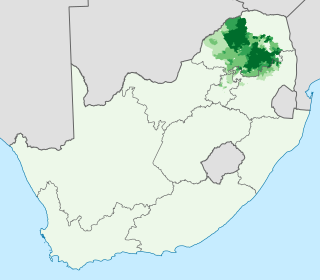
Northern Sotho, or Sesotho sa Leboa as an endonym, is a Sotho-Tswana language spoken in the northeastern provinces of South Africa. It is erroneous referred as Sepedi or Pedi, which is one of the Northern Sotho dialect, through synecdoche.

Tswana, also known by its native name Setswana, and previously spelled Sechuana in English, is a Bantu language spoken in Southern Africa by about 8.2 million people. It belongs to the Bantu language family within the Sotho-Tswana branch of Zone S (S.30), and is closely related to the Northern Sotho and Southern Sotho languages, as well as the Kgalagadi language and the Lozi language.

This article is about the demographic features of the population of Zimbabwe, including population density, ethnicity, education level, health of the populace, economic status, religious affiliations and other aspects of the population.

The population of South Africa is about 58.8 million people of diverse origins, cultures, languages, and religions. The South African National Census of 2022 was the most recent census held; the next will be in 2032.

Gauteng is one of the nine provinces of South Africa. The name in Sotho-Tswana languages means 'place of gold'.
Sotho or SesothoSouthern Sotho is a Southern Bantu language of the Sotho–Tswana ("S.30") group, spoken in Lesotho, where it is the national and official language; South Africa, where it is one of the 11 official languages; and in Zimbabwe where it is one of 16 official languages.

The Sotho people, also known as the Basuto or Basotho, are a Bantu nation native to southern Africa. Basothos have inhabited the region of Lesotho, South Africa since around the fifth century CE. They have split into different clans over time, due to succession fights within children of chiefs. There are 3 Basotho groupings in Southern Africa viz South Sotho, West Sotho and North Sotho and the reason why the white historians labeled them as South, West, North it is because when they arrived in present day South Africa, they found people in the present day Lesotho identifying themselves as Sothos and also in the present day North West province and Limpopo, they also identified themselves as Basothos and they decided to classify them by the direction of their locations. The Southern Basothos found themselves divided by colonialism into half, one group in South Africa and the other in Lesotho. The British and the Boers, [Dutch descendants] created Lesotho in the 1869 Convention of Aliwal North following the conflict over land between Moshoeshoe and the Dutch descendants.

The Southern Nations, Nationalities, and Peoples' Region is a regional state in southwestern Ethiopia. It was formed from the merger of five kililoch, called Regions 7 to 11, following the regional council elections on 21 June 1992. Its government is based in Hawassa.

Lebowa was a bantustan ("homeland") located in the Transvaal in northeastern South Africa. Seshego initially acted as Lebowa's capital while the purpose-built Lebowakgomo was being constructed. Granted internal self-government on 2 October 1972 and ruled for much of its existence by Cedric Phatudi, Lebowa was reincorporated into South Africa in 1994. It became part of the Limpopo province. The territory was not contiguous, being divided into two major and several minor portions.

Bultfontein is a town in the Free State province of South Africa with a total population of about 23,400 people. It is situated in the Tswelopele Local Municipality, about 100 kilometres (60 mi) north of Bloemfontein. The town site was laid out in 1873; it had been delayed because of a location dispute which also led to the establishment of Hoopstad 55 kilometres (35 mi) to the north-west. The township of Phahameng was established on the outskirts of Bultfontein in the 1970s.
Schweizer-Reneke, sometimes referred to as Schweizer, is a town in the North West Province of South Africa. It is the administrative centre of Mamusa Local Municipality. It is commonly referred to as Schweizer/ Mzwera.

At least thirty-five languages indigenous to South Africa are spoken in the Republic, eleven of which are official languages of South Africa: Ndebele, Pedi, Sotho, Swati, Tsonga, Tswana, Venda, Xhosa, Zulu, Afrikaans, and English, which is the primary language used in parliamentary and state discourse, though all official languages are equal in legal status. Unofficial languages are protected under the Constitution of South Africa, though few are mentioned by any name. South African Sign Language has legal recognition but is not an official language, despite a campaign and parliamentary recommendation for it to be declared one.
Elandspark is a suburb of Johannesburg, South Africa. It is located in Region 9.
Atholl is a suburb of Johannesburg, South Africa. It is located in Region E. Atholl was the name of a former district in the Scottish Highlands, which is now part of the Perth and Kinross council area.
Sandown is an affluent suburb of Johannesburg, South Africa, in Sandton. It is located in Region E of the City of Johannesburg Metropolitan Municipality. Sandown is both a residential and commercial area and is home to the offices of many major national and international corporations as well as the Johannesburg Stock Exchange in the area known as Sandton Central. The Gautrain rapid rail system's Sandton Station is located in Sandown, linking Sandton to O.R. Tambo International Airport, Johannesburg Central and the Capital City, Pretoria.

Waterkloof is a upmarket suburb of the city of Pretoria in the Gauteng province of South Africa, located to the east of the city centre. It is named after the original farm that stood there when Pretoria was founded in the 19th Century.
The Prehistory of South Africa lasts from the Middle Stone Age until the 17th century. Southern Africa was first reached by Homo sapiens before 130,000 years ago, possibly before 260,000 years ago. The region remained in the Late Stone Age until the first traces of pastoralism were introduced about 2,000 years ago. The Bantu migration reached the area now South Africa around the first decade of the 3rd century, over 1800 years ago. Early Bantu kingdoms were established by the 11th century. First European contact dates to 1488, but European colonization began in the 17th century.

Matatiele Local Municipality is a Category B municipality located in the Alfred Nzo District of Eastern Cape in South Africa. It adjoins Lesotho to the north, Elundini to the south-west, and Greater Kokstad to the east and its 4,352 km² makes the Matatiele Local Municipality largest of four municipalities in the district at almost half of its geographical area. [1]
The Bantu peoples, or Bantu, are an ethnolinguistic grouping of approximately 400 distinct ethnic groups who speak Bantu languages. They are native to 24 countries spread over a vast area from Central Africa to Southeast Africa and into Southern Africa. There are several hundred Bantu languages. Depending on the definition of "language" or "dialect", it is estimated that there are between 440 and 680 distinct languages. The total number of speakers is in the hundreds of millions, ranging at roughly 350 million in the mid-2010s. About 60 million speakers (2015), divided into some 200 ethnic or tribal groups, are found in the Democratic Republic of the Congo alone.

Racial groups in South Africa have a variety of origins. The racial categories introduced by Apartheid remain ingrained in South African society with South Africans and the South African government continuing to classify themselves, and each other, as belonging to one of the four defined race groups. Statistics South Africa asks people to describe themselves in the census in terms of five racial population groups. The 2011 census figures for these categories were Black South African at 76.4%, White South African at 9.1%, Coloured South African at 8.9%, Indian South African at 2.5%, and Other/Unspecified at 0.5%.

