Sentech

Last updated

Sentech
Sentech SA logo.svg
Agency overview
Formed1992
Jurisdiction Government of South Africa
Headquarters Johannesburg, Gauteng,
South Africa
Agency executive
  • Mlamli Booi [1] , CEO and Executive Director
Website sentech.co.za

Sentech is the signal distributor for the South African broadcasting sector.

Contents

Background

The Sentech Tower in Brixton, Johannesburg. South Africa-Johannesburg-Brixton Sentech Tower001.jpg
The Sentech Tower in Brixton, Johannesburg.

Sentech began operations in 1992 as the signal distributor of the South African Broadcasting Corporation (SABC). Sentech's mandate also included providing services to M-Net, Radio 702, Radio Ciskei, Radio Transkei and the Bophuthatswana Broadcasting Corporation.

However, in its Triple Inquiry report that was published in August 1995, the Independent Broadcasting Authority (IBA) recommended that Sentech should be split from the SABC and that Sentech become a public company. This report was approved by the South African Parliament in March 1996 and the Sentech Act to implement these measures was adopted by Parliament in November of the same year.

Sentech now operates as a commercial enterprise owned by the Government of South Africa via the Department of Communications and has its own board of directors.

From 2021 Sentech covers many areas of the country by Digital Terrestrial Television or Direct-to-Home platform [2]

Main radio/TV sites

ProvinceHistorical ProvinceLocationHeight of towerTransmitter Coordinates
Eastern Cape Cape Province Aliwal North 143 m 30°47′6″S26°33′58″E / 30.78500°S 26.56611°E / -30.78500; 26.56611 (Aliwal North transmitter)
Western Cape Beaufort West 204 m 32°15′30″S22°30′23″E / 32.25833°S 22.50639°E / -32.25833; 22.50639 (Beaufort West transmitter)
Eastern Cape Bedford 143 m 32°37′57″S26°2′56″E / 32.63250°S 26.04889°E / -32.63250; 26.04889 (Bedford transmitter)
Free State Orange Free State Bethlehem 174 m 28°14′12″S28°29′57″E / 28.23667°S 28.49917°E / -28.23667; 28.49917 (Bethlehem transmitter)
Free State Bloemfontein 204 m 29°6′13″S26°13′47″E / 29.10361°S 26.22972°E / -29.10361; 26.22972 (Bloemfontein transmitter)
Free State Boesmanskop235 m 30°0′28″S27°12′53″E / 30.00778°S 27.21472°E / -30.00778; 27.21472 (Boesmanskop transmitter)
Eastern Cape Cape Province Butterworth 235 m 32°16′35″S28°12′24″E / 32.27639°S 28.20667°E / -32.27639; 28.20667 (Butterworth transmitter)
Northern Cape Calvinia 213.5 m 31°23′3″S19°46′56″E / 31.38417°S 19.78222°E / -31.38417; 19.78222 (Calvinia transmitter)
Western Cape Cape Town (Constantiaberg)146 m 34°3′16″S18°23′12″E / 34.05444°S 18.38667°E / -34.05444; 18.38667 (Cape Town (Constantiaberg) transmitter)
Northern Cape Carnarvon 244 m 30°54′15″S22°22′27″E / 30.90417°S 22.37417°E / -30.90417; 22.37417 (Carnarvon transmitter)
Mpumalanga Transvaal Carolina (The Brook)213.5m 26°10′27″S30°38′6″E / 26.17417°S 30.63500°E / -26.17417; 30.63500 (Carolina (The Brook) transmitter)
North West Province Christiana 233 m 27°53′4″S24°55′47″E / 27.88444°S 24.92972°E / -27.88444; 24.92972 (Christiana transmitter)
Eastern Cape Cape Province Cradock 174 m 32°18′2″S25°32′26″E / 32.30056°S 25.54056°E / -32.30056; 25.54056 (Cradock transmitter)
Mpumalanga Transvaal Davel 265 m 26°27′32″S29°37′25″E / 26.45889°S 29.62361°E / -26.45889; 29.62361 (Davel transmitter)
Northern Cape Cape Province De Aar 204 m 30°27′50″S23°59′13″E / 30.46389°S 23.98694°E / -30.46389; 23.98694 (De Aar transmitter)
KwaZulu-Natal Natal Donnybrook 122 m 29°54′58″S29°51′18″E / 29.91611°S 29.85500°E / -29.91611; 29.85500 (Donnybrook transmitter)
Northern Cape Cape Province Douglas 242 m 29°4′8″S23°31′43″E / 29.06889°S 23.52861°E / -29.06889; 23.52861 (Douglas transmitter)
Mpumalanga Transvaal Dullstroom 25°34′23″S30°11′16″E / 25.57306°S 30.18778°E / -25.57306; 30.18778 (Dullstroom transmitter)
KwaZulu-Natal Natal Durban (Alverstone)247 m 29°46′12″S30°43′0″E / 29.77000°S 30.71667°E / -29.77000; 30.71667 (Durban (Alverstone) transmitter)
Eastern Cape Cape Province East London 204 m 32°56′21″S27°48′55″E / 32.93917°S 27.81528°E / -32.93917; 27.81528 (East London transmitter)
KwaZulu-Natal Natal Eshowe 143 m 28°51′32″S31°17′35″E / 28.85889°S 31.29306°E / -28.85889; 31.29306 (Eshowe transmitter)
Northern Cape Cape Province Faans Grove 146 m 27°6′0″S22°24′16″E / 27.10000°S 22.40444°E / -27.10000; 22.40444 (Faans Grove transmitter)
Northern Cape Garies 213.5 m 30°18′53″S18°4′40″E / 30.31472°S 18.07778°E / -30.31472; 18.07778 (Garies transmitter)
Western Cape George 143 m 33°55′39″S22°27′1″E / 33.92750°S 22.45028°E / -33.92750; 22.45028 (George transmitter)
KwaZulu-Natal Natal Glencoe (Fort Mistake)143 m 28°9′5″S29°56′51″E / 28.15139°S 29.94750°E / -28.15139; 29.94750 (Glencoe (Fort Mistake) transmitter)
Eastern Cape Cape Province Graaff Reinet 32°4′48″S24°26′59″E / 32.08000°S 24.44972°E / -32.08000; 24.44972 (Graaff Reinet transmitter)
Eastern Cape Grahamstown 204 m 33°17′15″S26°42′30″E / 33.28750°S 26.70833°E / -33.28750; 26.70833 (Grahamstown transmitter)
KwaZulu-Natal Natal Greytown 174 m 29°0′47″S30°32′9″E / 29.01306°S 30.53583°E / -29.01306; 30.53583 (Greytown transmitter)
Limpopo Transvaal Hoedspruit 24°32′32″S30°52′7″E / 24.54222°S 30.86861°E / -24.54222; 30.86861 (Hoedspruit transmitter)
Gauteng Johannesburg 237 m 26°11′33″S28°0′25″E / 26.19250°S 28.00694°E / -26.19250; 28.00694 (Johannesburg transmitter)
Eastern Cape Cape Province Kareedouw 34°1′30″S24°25′47″E / 34.02500°S 24.42972°E / -34.02500; 24.42972 (Kareedouw transmitter)
Northern Cape Kimberley 235 m 28°51′15″S24°54′17″E / 28.85417°S 24.90472°E / -28.85417; 24.90472 (Kimberley transmitter)
Eastern Cape King William's Town (Keiskammahoek)174 m 32°40′48″S27°15′36″E / 32.68000°S 27.26000°E / -32.68000; 27.26000 (King William's Town (Keiskammahoek) transmitter)
North West Province Transvaal Klerksdorp (Hartbeesfontein)265 m 26°45′15″S26°24′28″E / 26.75417°S 26.40778°E / -26.75417; 26.40778 (Klerksdorp (Hartbeesfontein) transmitter)
Free State Orange Free State Kroonstad 235 m 27°25′17″S27°11′7″E / 27.42139°S 27.18528°E / -27.42139; 27.18528 (Kroonstad transmitter)
Northern Cape Cape Province Kuruman Hills 241 m 27°53′13″S23°33′37″E / 27.88694°S 23.56028°E / -27.88694; 23.56028 (Kuruman Hills transmitter)
Free State Orange Free State Ladybrand 174 m 29°10′19″S27°22′41″E / 29.17194°S 27.37806°E / -29.17194; 27.37806 (Ladybrand transmitter)
Limpopo Transvaal Louis Trichardt 143 m 23°0′5″S29°45′27″E / 23.00139°S 29.75750°E / -23.00139; 29.75750 (Louis Trichardt transmitter)
Eastern Cape Cape Province Matatiele 213.5 m 30°23′47″S28°49′15″E / 30.39639°S 28.82083°E / -30.39639; 28.82083 (Matatiele transmitter)
Western Cape Matjiesfontein 143 m 33°16′54″S20°30′17″E / 33.28167°S 20.50472°E / -33.28167; 20.50472 (Matjiesfontein transmitter)
Mpumalanga Transvaal Middelburg 244 m 25°49′6″S29°23′23″E / 25.81833°S 29.38972°E / -25.81833; 29.38972 (Middelburg transmitter)
KwaZulu-Natal Natal Mooi River 174 m 29°11′9″S29°52′3″E / 29.18583°S 29.86750°E / -29.18583; 29.86750 (Mooi River transmitter)
Eastern Cape Cape Province Mount Ayliff 137 m 30°50′14″S29°23′41″E / 30.83722°S 29.39472°E / -30.83722; 29.39472 (Mount Ayliff transmitter)
Western Cape Napier (Bredasdorp)143 m 34°31′46″S19°53′33″E / 34.52944°S 19.89250°E / -34.52944; 19.89250 (Napier transmitter)
Mpumalanga Transvaal Nelspruit 25°30′57″S30°46′33″E / 25.51583°S 30.77583°E / -25.51583; 30.77583 (Nelspruit transmitter)
KwaZulu-Natal Natal Nongoma 183 m 27°54′19″S31°39′26″E / 27.90528°S 31.65722°E / -27.90528; 31.65722 (Nongoma transmitter)
Eastern Cape Cape Province Noupoort 174 m 31°18′14″S24°55′59″E / 31.30389°S 24.93306°E / -31.30389; 24.93306 (Noupoort transmitter)
Western Cape Oudtshoorn 143 m 33°40′17″S22°16′1″E / 33.67139°S 22.26694°E / -33.67139; 22.26694 (Oudtshoorn transmitter)
Free State Orange Free State Petrus Steyn 235 m 27°31′1″S28°19′6″E / 27.51694°S 28.31833°E / -27.51694; 28.31833 (Petrus Steyn transmitter)
Mpumalanga Transvaal Piet Retief 265 m 27°1′13″S30°41′2″E / 27.02028°S 30.68389°E / -27.02028; 30.68389 (Piet Retief transmitter)
Western Cape Cape Province Piketberg 174 m 32°49′9″S18°44′17″E / 32.81917°S 18.73806°E / -32.81917; 18.73806 (Piketberg transmitter)
Eastern Cape Port Elizabeth 204 m 33°56′10″S25°26′27″E / 33.93611°S 25.44083°E / -33.93611; 25.44083 (Port Elizabeth transmitter)
KwaZulu-Natal Natal Port Shepstone 204 m 30°44′8″S30°17′16″E / 30.73556°S 30.28778°E / -30.73556; 30.28778 (Port Shepstone transmitter)
Limpopo Transvaal Potgietersrus 24°9′26″S29°14′9″E / 24.15722°S 29.23583°E / -24.15722; 29.23583 (Potgietersrus transmitter)
Gauteng Transvaal Pretoria 113 m 25°41′22″S27°59′2″E / 25.68944°S 27.98389°E / -25.68944; 27.98389 (Pretoria transmitter)
Northern Cape Cape Province Prieska 244 m 29°40′54″S22°36′55″E / 29.68167°S 22.61528°E / -29.68167; 22.61528 (Prieska transmitter)
Eastern Cape Queenstown 143 m 31°43′58″S26°47′3″E / 31.73278°S 26.78417°E / -31.73278; 26.78417 (Queenstown transmitter)
Western Cape Riversdale 143 m 34°1′8″S21°7′39″E / 34.01889°S 21.12750°E / -34.01889; 21.12750 (Riversdale transmitter)
North West Province Transvaal Rustenburg 113 m 25°36′59″S27°7′5″E / 25.61639°S 27.11806°E / -25.61639; 27.11806 (Rustenburg transmitter)
North West Province Schweizer-Reneke 265 m 27°8′10″S25°13′7″E / 27.13611°S 25.21861°E / -27.13611; 25.21861 (Schweizer-Reneke transmitter)
Free State Orange Free State Senekal 235 m 28°15′21″S27°30′25″E / 28.25583°S 27.50694°E / -28.25583; 27.50694 (Senekal transmitter)
Northern Cape Cape Province Springbok 241 m 29°35′4″S17°48′26″E / 29.58444°S 17.80722°E / -29.58444; 17.80722 (Springbok transmitter)
Free State Orange Free State Springfontein 143 m 30°16′15″S25°46′7″E / 30.27083°S 25.76861°E / -30.27083; 25.76861 (Springfontein transmitter)
Eastern Cape Cape Province Suurberg 204 m 33°14′55″S25°34′27″E / 33.24861°S 25.57417°E / -33.24861; 25.57417 (Suurberg transmitter)
Limpopo Transvaal Thabazimbi 183 m 24°28′2″S27°36′50″E / 24.46722°S 27.61389°E / -24.46722; 27.61389 (Thabazimbi transmitter)
Free State Orange Free State Theunissen 265 m 28°11′56″S26°34′48″E / 28.19889°S 26.58000°E / -28.19889; 26.58000 (Theunissen transmitter)
Limpopo Transvaal Tzaneen (Houtbosdorp) 23°47′7″S30°0′16″E / 23.78528°S 30.00444°E / -23.78528; 30.00444 (Tzaneen (Houtbosdorp) transmitter)
KwaZulu-Natal Natal Ubombo 27°33′44″S32°4′50″E / 27.56222°S 32.08056°E / -27.56222; 32.08056 (Ubombo transmitter)
Eastern Cape Cape Province Umtata 235 m 31°35′49″S28°44′36″E / 31.59694°S 28.74333°E / -31.59694; 28.74333 (Umtata transmitter)
Northern Cape Upington 244 m 28°52′58″S21°44′11″E / 28.88278°S 21.73639°E / -28.88278; 21.73639 (Upington transmitter)
Western Cape Vanrhynsdorp 183 m 31°45′16″S18°41′21″E / 31.75444°S 18.68917°E / -31.75444; 18.68917 (Van Rhynsdorp transmitter)
Western Cape Villiersdorp 143 m 33°58′10″S19°30′22″E / 33.96944°S 19.50611°E / -33.96944; 19.50611 (Villiersdorp transmitter)
Mpumalanga Transvaal Volksrust 174 m 27°18′36″S29°53′15″E / 27.31000°S 29.88750°E / -27.31000; 29.88750 (Volksrust transmitter)
KwaZulu-Natal Natal Vryheid 143 m 27°44′29″S30°47′37″E / 27.74139°S 30.79361°E / -27.74139; 30.79361 (Vryheid transmitter)
Gauteng Transvaal Welverdiend 143 m 26°26′49″S27°14′53″E / 26.44694°S 27.24806°E / -26.44694; 27.24806 (Welverdiend transmitter)
North West Province Zeerust (Ottoshoop)264 m 25°51′38″S26°2′50″E / 25.86056°S 26.04722°E / -25.86056; 26.04722 (Zeerust (Ottoshoop) transmitter)

See also

Related Research Articles

<span class="mw-page-title-main">Television in South Africa</span>

Television in South Africa was introduced in 1976. The country is notable for the late introduction of widespread television broadcasting.

<span class="mw-page-title-main">SABC</span> State-owned public broadcaster in South Africa

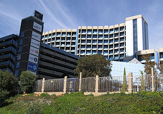
The South African Broadcasting Corporation (SABC) is the public broadcaster in South Africa, and provides 19 radio stations (AM/FM) as well as 6 television broadcasts and 3 OTT Services to the general public. It is one of the largest of South Africa's state-owned enterprises and the biggest state broadcaster in Africa.

TVO, formerly known as TVOntario, is a Canadian publicly funded English-language educational television network and media organization serving the Canadian province of Ontario. It operates flagship station CICA-DT in Toronto, which also relays programming across portions of Ontario through eight rebroadcast stations. All pay television providers throughout Ontario are required to carry TVO on their basic tier, and programming can be streamed for free online within Canada.

<span class="mw-page-title-main">Brixton Tower</span> Cantilever concrete-shafted television tower in Gauteng, South Africa

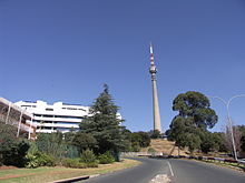
The Sentech Tower, previously named the Albert Hertzog Tower and commonly known as the Brixton Tower, is a 237-metre-high (778 ft) concrete television tower in the Brixton suburb of Johannesburg, South Africa, near the top of the Brixton Ridge. It is a well-known and easily identifiable landmark in the city, alongside its "architectural cousin", the Hillbrow Tower. Although always intended for both radio and television transmission, it carried only FM radio transmissions until the 1970s.

<span class="mw-page-title-main">CHAU-DT</span> TVA affiliate in Carleton-sur-Mer, Quebec

CHAU-DT is a French language television station serving as an affiliate of TVA in Carleton-sur-Mer, Quebec, Canada. It broadcasts an analogue signal on VHF channel 5 from a transmitter near Rue de la Montagne in Carleton-sur-Mer.

<span class="mw-page-title-main">Jacaranda FM</span> South African radio station

Jacaranda FM, previously known as Jacaranda 94.2, is a South African radio station, broadcasting in English and Afrikaans, with a footprint that covers Gauteng, Limpopo, Mpumalanga and the North West Province and boasts a listening audience of 2 million people a week and a digital community of more than 1.1 million people a month. The station's format is mainstream with programming constructed around a playlist of hit music from the 1980s, 1990s and now.

<span class="mw-page-title-main">SAfm</span> National public radio station in South Africa

SAfm is a national, English-language public radio station in South Africa. It has been operated by the South African Broadcasting Corporation (SABC) since its founding in 1936.

<span class="mw-page-title-main">Radio Sonder Grense</span> Radio station

Radio Sonder Grense (RSG), i.e. Radio Without Borders, is an Afrikaans-language radio service run by the South African Broadcasting Corporation for the whole of South Africa. Since Afrikaans is one of South Africa's 11 official languages, the SABC is required to carry an Afrikaans-language service on both radio and television. RSG is the radio part of this Afrikaans-language service. RSG broadcasts mostly on FM utilizing transmitters owned and operated by Sentech, the former signal distribution division of the SABC.

<span class="mw-page-title-main">Mississippi Public Broadcasting</span> Public broadcaster of the state of Mississippi, United States

Mississippi Public Broadcasting (MPB) is the public broadcasting network serving the U.S. state of Mississippi. It is owned by the Mississippi Authority for Educational Television (MAET), an agency of the state government that holds the licenses for all of the PBS and NPR member stations in the state. MPB's headquarters is located on Ridgewood Road in northeast Jackson. The public broadcaster was established as Mississippi Educational Television.

Channel Africa is the international broadcasting service of the South African Broadcasting Corporation.

<span class="mw-page-title-main">ABN (TV station)</span> Television station in New South Wales, Australia

ABC Television in New South Wales comprises national and local programming on the ABC television network in the Australian state of New South Wales, headquartered in Sydney.

<span class="mw-page-title-main">ABT (TV station)</span> Television station in Hobart, Tasmania, Australia

ABT is the call sign of a television station operated by the publicly-owned Australian Broadcasting Corporation, with a transmission area covering southern Tasmania. ABT began broadcasting on VHF channel 2 on 4 June 1960, with studios in inner-city Hobart and transmitter at Mount Wellington. The "AB" in the call sign stands for "Australian Broadcasting", as in Australian Broadcasting Commission. The "T" in the call sign stands for Tasmania.

<span class="mw-page-title-main">ABQ</span> Television station in Queensland, Australia

ABC Television in Queensland comprises national programming on the ABC television network in or from Brisbane, Queensland which broadcasts on a number of channels under the ABC call sign. There is some local programming from the Brisbane studio.

<span class="mw-page-title-main">ABS (TV station)</span> Television station in South Australia, Australia

ABC Television in South Australia comprises national and local programming on the ABC television network in the Australian state of South Australia, headquartered in Adelaide.

Motsweding FM is an SABC radio station based in Mahikeng, South Africa, broadcasting mainly in the Tswana language. Formerly known as Radio Tswana, the country-wide broadcast station evolved from a Bophuthatswana Broadcasting Corporation, which had been operating from Mmabatho in the former Bophuthatswana homeland.

<span class="mw-page-title-main">Pretoria FM</span> Radio station in Pretoria

Pretoria FM, formerly Radio Pretoria is an Afrikaans community-based radio station in Pretoria, South Africa. It broadcasts 24 hours a day in stereo on 104.2 FM in the greater Pretoria area. Various other transmitters in South Africa broadcast the station's content further afield, while the station is also available on Sentech's digital satellite platform. The station was founded seven months before the 1994 elections. From the start, it identified itself as a radio station for the Afrikaans speaking community. For a brief period, it broadcast informally from a makeshift studio east of Pretoria. Broadcasts were made possible with the help of among others, retired SABC employees. Post-1994, Radio Pretoria struggled for years to secure a permanent broadcasting license from the ANC government.

Radio and TV broadcasting in Pretoria is supplied via a network of VHF/FM and UHF transmitters and repeaters owned and operated by Sentech - South Africa's state-owned broadcast signal distributor - from four transmitter sites in and around the city. A number of community radio stations operate transmitters from non-Sentech sites.

<span class="mw-page-title-main">Cape Town TV</span> Community television channel in South Africa

Cape Town TV is a community television channel that broadcasts in Cape Town, South Africa. It launched in September 2008 with a one-year, "temporary" license and thereafter won another such license in September 2009. It is a non-profit organisation that is licensed as a community broadcaster in terms of South Africa's Electronic Communications Act.

<span class="mw-page-title-main">SABC Sport</span> South African television channel

SABC SPORT is a South African free-to-air sports television channel owned by the South African Broadcasting Corporation (SABC).

AstraSat was the South African Broadcasting Corporation's satellite television service that existed between 1996 and 1998. AstraSat carried SABC's three terrestrial television networks and two additional free-to-air channels that were aimed at becoming subscription channels. Numerous factors including the reliance on analogue instead of digital led to its closure in February 1998.

References

  1. "Executive members". Sentech. Retrieved 17 November 2019.
  2. Coverage Information service map Sentech.co.za 2021