The Province of Natal, commonly called Natal, was a province of South Africa from May 1910 until May 1994. Its capital was Pietermaritzburg. During this period rural areas inhabited by the black African population of Natal were organised into the bantustan of KwaZulu, which was progressively separated from the province, becoming partially autonomous in 1981. Of the white population, the majority were English-speaking people of British descent, causing Natal to become the only province to vote "No" to the creation of a republic in the referendum of 1960, due to very strong monarchist, pro-British Commonwealth, and anti-secessionist sentiment. In the latter part of the 1980s, Natal was in a state of violence between the Inkatha Freedom Party and the African National Congress, with violence subsiding soon after the first non-racial election in 1994.

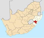
KwaZulu-Natal is a province of South Africa that was created in 1994 when the government merged the Zulu bantustan of KwaZulu and Natal Province.
Pietermaritzburg is the capital and second-largest city in the province of KwaZulu-Natal, South Africa after Durban. It was named in 1838 and is currently governed by the Msunduzi Local Municipality. The town was named in Zulu after King Dingane's royal homestead uMgungundlovu. Pietermaritzburg is popularly called Maritzburg in Afrikaans and is often informally abbreviated to PMB. It is a regionally important industrial hub, producing aluminium, timber and dairy products, as well as the main economic hub of uMgungundlovu District Municipality. The public sector is a major employer in the city due to local, district and provincial government offices located here.

Ladysmith is a town in the Uthukela District of KwaZulu-Natal, South Africa. It lies 230 kilometres (140 mi) north-west of Durban and 365 kilometres (227 mi) south-east of Johannesburg. Important industries in the area include food processing, textiles, and tyre production. Ladysmith is the seat for both the Alfred Duma Local Municipality and Uthukela District Municipality.

Estcourt is a town in the uThukela District of KwaZulu-Natal Province, South Africa. The main economic activity is farming with large bacon and processed food factories situated around the town. The N3 freeway passes close to the town, linking it to the rest of South Africa.
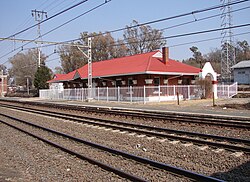
Glencoe is situated in the Umzinyathi District, District of KwaZulu-Natal, South Africa.

The N3 is a national route in South Africa that connects Johannesburg and Durban, respectively South Africa's largest and third-largest cities. Johannesburg is the financial and commercial heartland of South Africa, while Durban is South Africa's key port and one of the busiest ports in the Southern Hemisphere and is also a holiday destination. Durban is the port through which Johannesburg imports and exports most of its goods. As a result, the N3 is a very busy highway and has a high volume of traffic.

Port Shepstone is a large town situated on the mouth of the Mzimkhulu River, the largest river on the KwaZulu-Natal South Coast of South Africa. It is located halfway between Hibberdene and Margate and is positioned 120 km south of Durban. It serves as the administrative, educational, industrial and commercial centre for southern Natal.
Colenso is a town in KwaZulu-Natal, South Africa. It is located on the southern bank of the Tugela River on the R103 road. The original settlement was contained within a loop on the river, but it subsequently expanded southwards and eastwards. It lies on the main Durban - Johannesburg railway line some 190 km (118 mi) north-west of Durban.

Newcastle is the third-largest city in the province of KwaZulu-Natal, South Africa and is the province's industrial centre. The city has four industrial areas. The majority of its citizens reside in Newcastle East in the main townships of Madadeni and Osizweni, with the balance residing in Newcastle West. Set at the foothills of the northern KwaZulu-Natal Drakensberg Mountains, Newcastle is located in the northwest corner of the province along the Ncandu River.
Bergville is a small town situated in the foothills of the Drakensberg mountains, KwaZulu-Natal, South Africa. It was established as Bergville Mountain Village in 1897 and is now the commercial centre for a 2,500 km2 dairy and cattle ranching area. A blockhouse was built by the British soldiers in the town during the Second Boer War
Harrismith is a large town in the Free State province of South Africa. It was named for Sir Harry Smith, a 19th-century British governor and high commissioner of the Cape Colony. It is situated by the Wilge River, alongside the N3 highway, about midway between Johannesburg, about 275 km to the north-west, and Durban to the southeast. The town is located at the junction of the N5 highway, which continues westward towards the provincial capital Bloemfontein, some 340 km to the south-west. This important crossroads in South Africa's land trade routes is surrounded by mesas and buttes. It is located at the base of one of these called Platberg.
Pinetown is a city that forms part of the eThekwini Metropolitan Municipality, based just inland from Durban in KwaZulu-Natal, South Africa. The city is situated 16 km north-west of Durban and 64 km south-east of Pietermaritzburg.
Queensburgh is a town in KwaZulu-Natal, South Africa that is situated inland (southwest) from Durban and now forms part of eThekwini, the Greater Durban metropolitan area.
Westville is an area in KwaZulu-Natal, South Africa, and is just west and 10 km inland from the Durban CBD. It was formerly and independent municipality and became part of the eThekwini Metropolitan Municipality in 2002.

The KwaZulu-Natal midlands is an inland area of KwaZulu-Natal, South Africa that starts from Pietermaritzburg and ends before the Drakensberg mountain range; between Pietermaritzburg, Estcourt and Greytown.

During the Napoleonic Wars, the Cape Colony was annexed by the British and officially became their colony in 1815. Britain encouraged settlers to the Cape, and in particular, sponsored the 1820 Settlers to farm in the disputed area between the colony and the Xhosa in what is now the Eastern Cape. The changing image of the Cape from Dutch to British excluded the Dutch farmers in the area, the Boers who in the 1820s started their Great Trek to the northern areas of modern South Africa. This period also marked the rise in power of the Zulu under their king Shaka Zulu. Subsequently, several conflicts arose between the British, Boers and Zulus, which led to the Zulu defeat and the ultimate Boer defeat in the Second Anglo-Boer War. However, the Treaty of Vereeniging established the framework of South African limited independence as the Union of South Africa.
Treverton Preparatory School and College, situated in Mooi River, South Africa, cater to boys and girls of all faiths from Grades 0 to 12 and Post-Matric. As a member of the Independent Schools Association of Southern Africa (ISASA), Treverton is an inter-denominational Christian school founded on a Baptist heritage.Treverton Preparatory School and college is a private school and college

The KwaZulu-Natal South Coast is a region along the southern stretch of coastline of KwaZulu-Natal, South Africa, south of the coastal city of Durban.

Christopher "Chris" John Pappas is a South African politician who is the mayor of the uMngeni Local Municipality. A member of the Democratic Alliance, he served as party's deputy provincial leader from 2021 until 2023. Pappas served as a member of the eThekwini city council from 2016 until 2019 and as a DA Member of the KwaZulu-Natal Legislature from 2019 to 2021.