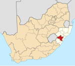
KwaZulu-Natal is a province of South Africa that was created in 1994 when the government merged the Zulu bantustan of KwaZulu and Natal Province.
Pietermaritzburg is the capital and second-largest city in the province of KwaZulu-Natal, South Africa after Durban. It was named in 1838 and is currently governed by the Msunduzi Local Municipality. The town was named in Zulu after King Dingane's royal homestead uMgungundlovu. Pietermaritzburg is popularly called Maritzburg in Afrikaans and is often informally abbreviated to PMB. It is a regionally important industrial hub, producing aluminium, timber and dairy products, as well as the main economic hub of uMgungundlovu District Municipality. The public sector is a major employer in the city due to local, district and provincial government offices located here.

Mooi River is a small town situated at 1,389 m above sea level and 160 km from the coast in KwaZulu-Natal, South Africa. The first European settlement in the area was at Mooi River Drift in 1852. This was formally named Weston in 1866 after the first Governor of Natal, Martin West.
New Hanover is a small town in the midlands of KwaZulu-Natal, South Africa, 35 kilometres (22 mi) north-east of Pietermaritzburg and 37 kilometres (23 mi) south of Greytown. It was founded in 1850 and has been administered by a health committee since 1933. It was named after city of Hanover in Germany by the German settlers.
Greytown is a town situated on the banks of a tributary of the uMvoti River in a richly fertile timber-producing area of KwaZulu-Natal, South Africa.
Hilton is a small town that lies between Howick and Pietemaritzburg in the province of KwaZulu-Natal, South Africa. In 1872 the Reverend William Orde Newnham opened Hilton College on a large estate 7.8km north of the town, which is now one of South Africa's leading private schools.
Hilton College, more commonly referred to as Hilton, is a South African private boarding school for boys located near the town of Hilton in the KwaZulu-Natal Midlands and is situated on a 1,762 ha estate that includes a 550 ha wildlife reserve and the 150 ha school campus
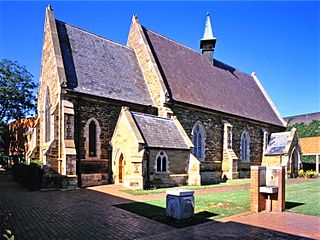
St Anne's Diocesan College is a private girls' boarding school situated in the small town of Hilton in the KwaZulu-Natal Midlands of South Africa.

The KwaZulu-Natal midlands is an inland area of KwaZulu-Natal, South Africa that starts from Pietermaritzburg and ends before the Drakensberg mountain range.
Clifton Preparatory School, Nottingham Road is a private, co-educational day and boarding primary school located in the Nottingham Road area of the KwaZulu-Natal Midlands in South Africa.
Cordwalles is a private, boarding preparatory school for boys founded in 1912. It is located in Pietermaritzburg, the capital city of KwaZulu-Natal, South Africa.
Howick High School is a coeducational public school in Howick, KwaZulu-Natal, South Africa, established on 27 June 1967. Whilst it has a weekly boarding facility, known as Midmar House, which can accommodate up to 100 students who live in the local surrounding districts, Howick High School is not a full-time boarding school.
David Grey Rattray was a South African historian of the 1879 Anglo-Zulu War in South Africa, also well known as a tour guide.
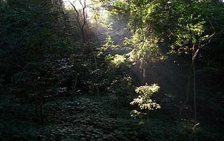
Areas of forest which grow in KwaZulu-Natal, South Africa mostly on south facing slopes in higher rainfall areas, and along the humid coastal areas. Different types of forest can be identified by their species composition which depends mostly on the altitude, latitude and substrate in which they grow. South facing slopes are favourable for the development of forest as they are more shaded, and therefore cooler and retain more moisture than the northern slopes. The extra moisture on the south slopes is not only favoured by forest trees, but also helps to prevent or subdue wildfires. Fires can also be blocked by cliff faces and rocks or boulders on these slopes, and by streams or rivers at the base of the slopes. The coastal regions are conducive to forest formation, because of high rainfall and humidity which are favoured by forest trees and also help to prevent or subdue fires. The rivers of the coastal areas are also broader than further inland, which may often prevent fires from spreading long distances, and fires generally burn uphill and therefore more often away from areas at low altitude.

Wartburg is a small town located 27 kilometres (17 mi) north-east of Pietermaritzburg and 50 kilometres (31 mi) south of Greytown in the uMshwathi Local Municipality of KwaZulu-Natal, South Africa.

Michaelhouse is a full boarding senior school for boys founded in 1896. It is located in the Balgowan valley in the Midlands of KwaZulu-Natal, South Africa.

Frankie's is a South African soft drink company based in Balgowan, KwaZulu-Natal. It specialises in the production of niche soft drinks that have the same or similar taste to soft drinks from or before the 1950s.
Lions River is a town in uMngeni Local Municipality in the KwaZulu-Natal province of South Africa, situated between Lidgetton and Howick in the center of the KwaZulu-Natal Midlands. Its name originates from the last lion which was shot in the area in 1856.
Jean van der Westhuyzen is an Australian sprint canoeist. He was educated at Michaelhouse, Balgowan, KwaZulu Natal.