UMngeni Local Municipality

Last updated
uMngeni
UMngeni CoA.png
Map of KwaZulu-Natal with Umngeni highlighted.svg
Location in KwaZulu-Natal
Country South Africa
Province KwaZulu-Natal
District uMgungundlovu
Seat Howick
Wards 13
Government
[1]
  Type Municipal council
  Mayor Chris Pappas (DA)
  Deputy MayorSandile Mnikathi (DA)
Area
  Total1,567 km2 (605 sq mi)
Population
 (2011) [2]
  Total92,710
  Density59/km2 (150/sq mi)
Racial makeup (2011)
[2]
   Black African 75.0%
   Coloured 1.5%
   Indian/Asian 3.8%
   White 19.4%
First languages (2011)
[2]
   Zulu 64.3%
   English 25.5%
   Sotho 3.8%
   Afrikaans 2.1%
  Other4.3%
Time zone UTC+2 (SAST)
Municipal codeKZN222

uMngeni Municipality (Zulu : UMasipala wase Mngeni) is a local municipality within the Umgungundlovu District Municipality, in the KwaZulu-Natal province of South Africa. The municipality is named after the uMngeni River that runs through the municipal area. [3]

Contents

Main places

The 2011 census divided the municipality into the following main places: [4]

PlaceCodeArea (km2)PopulationMost spoken language
Balgowan 3.84980 English
Cedara 16.171,280 Zulu
Cedarge 6.785,888Zulu
Emashingeni 2.52720Zulu
Fort Nottingham 0.5238Zulu
Garlington 1.35186English
Hilton 30.909,340English
Howick 29.3221,639English
Karkloof Nature Reserve 07.99
KwaMevana 3.165,102Zulu
Lidgetton West 7.994,521Zulu
Lions River 2.41970Zulu
Midmar 29.6895Zulu
Mpophomeni 4,5825,732Zulu
Nottingham Road 3.071,277Zulu
Zenzani 0.43509Zulu
Remainder of the municipality 1,415.7914,443Zulu

Politics

The municipal council consists of twenty-five members elected by mixed-member proportional representation. Twelve councilors are elected by first-past-the-post voting in twelve wards, while the remaining are chosen from party lists so that the total number of party representatives is proportional to the number of votes received. In the 2021 South African municipal elections the Democratic Alliance (DA) won a majority of thirteen seats in the council.

The following table shows the results of the 2021 election.

uMngeni local election, 1 November 2021 [5] [6] [7]
PartyVotesSeats
WardListTotal %WardListTotal
Democratic Alliance 14,03514,31028,34547.45813
African National Congress 11,10012,31923,41939.28210
Economic Freedom Fighters 2,1222,0194,1416.9022
Independent candidates 2,2562,2563.800
6 other parties6879351,6222.7000
Total30,20029,58359,783131225
Valid votes30,20029,58359,78398.2
Spoilt votes 6604501,1101.8
Total votes cast30,86030,03360,893
Voter turnout30,883
Registered voters54,063
Turnout percentage57.1

Related Research Articles

<span class="mw-page-title-main">Inxuba Yethemba Local Municipality</span> Local municipality in Eastern Cape, South Africa

Inxuba Yethemba Municipality, formerly known as Cradock Municipality, is a local municipality within the Chris Hani District Municipality, in the Eastern Cape province of South Africa. The seat is Cradock.

<span class="mw-page-title-main">Albert Luthuli Local Municipality</span> Local municipality in Mpumalanga, South Africa

Albert Luthuli Municipality is a local municipality within the Gert Sibande District Municipality, in the Mpumalanga province of South Africa. It was named after Albert Luthuli. Carolina is the seat of the municipality.

<span class="mw-page-title-main">Thabazimbi Local Municipality</span> Local municipality in Limpopo, South Africa

Thabazimbi Municipality is a local municipality within the Waterberg District Municipality, in the Limpopo province of South Africa. The seat is Thabazimbi.

<span class="mw-page-title-main">Musina Local Municipality</span> Local municipality in Limpopo, South Africa

Musina Municipality is a local municipality within the Vhembe District Municipality, in the Limpopo province of South Africa. It is the northernmost local municipality in South Africa. It borders Botswana, Mozambique and Zimbabwe. The seat is Musina.

<span class="mw-page-title-main">Nkandla Local Municipality</span> Local municipality in KwaZulu-Natal, South Africa

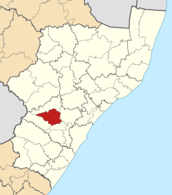
Nkandla Local Municipality is an administrative area in the King Cetshwayo District of KwaZulu-Natal province in South Africa. The town of Nkandla is the home town of the former President of South Africa, Jacob Zuma.

uMhlathuze Local Municipality Local municipality in KwaZulu-Natal, South Africa

uMhlathuze Local Municipality is an administrative area in the King Cetshwayo District Municipality of KwaZulu-Natal in South Africa. The municipality is named after the Mhlatuze River.

<span class="mw-page-title-main">Endumeni Local Municipality</span> Local municipality in KwaZulu-Natal, South Africa

Endumeni Municipality is a local municipality within the Umzinyathi District Municipality, in the KwaZulu-Natal province of South Africa. Endumeni is an isiZulu word meaning "a place of thunderstorm". The municipality shares its name with the Endumeni hill.

<span class="mw-page-title-main">Kwa Sani Local Municipality</span> Former local municipality in KwaZulu-Natal, South Africa

Kwa Sani Local Municipality was an administrative area in the Harry Gwala of KwaZulu-Natal in South Africa.

uMdoni Local Municipality Area in KwaZulu-Natal, South Africa

uMdoni Municipality is a local municipality within the Ugu District Municipality, in the KwaZulu-Natal province of South Africa. uMdoni is the isiZulu name for the indigenous forest waterberry plant.

<span class="mw-page-title-main">Umzimkhulu Local Municipality</span> Local municipality in KwaZulu-Natal, South Africa

Umzimkhulu Municipality is a local municipality within the Harry Gwala District Municipality, in the KwaZulu-Natal province of South Africa. Umzimkhulu is an isiXhosa and isiZulu word meaning "big/great house". Prior to the Twelfth Amendment of the Constitution of South Africa in 2005, confirmed by the Thirteenth in 2007, it was part of the Eastern Cape.

<span class="mw-page-title-main">Ezinqoleni Local Municipality</span> Former local municipality in KwaZulu-Natal, South Africa

Ezinqoleni Local Municipality was an administrative area in the Ugu District of KwaZulu-Natal in South Africa.

uMuziwabantu Local Municipality Local municipality in KwaZulu-Natal, South Africa

uMuziwabantu Municipality is a local municipality within the Ugu District Municipality, in the KwaZulu-Natal province of South Africa. uMuziwabantu is an isiZulu word meaning "the people's home", or "a home with wide open doors where everyone is welcome". The main source of income for the area is derived from the municipality's extensive wattle, gum, pine and poplar plantations, and associated industries, including saw mills and furniture-making factories.

<span class="mw-page-title-main">Umzumbe Local Municipality</span> Local municipality in KwaZulu-Natal, South Africa

Umzumbe Municipality is a local municipality within the Ugu District Municipality, in the KwaZulu-Natal province of South Africa. The municipality is named after the Umzumbe River. Towns within the municipal boundaries include Friedenau, KwaDweshula, St Faith’s, and Umzumbe.

<span class="mw-page-title-main">Umtshezi Local Municipality</span> Local municipality in KwaZulu-Natal, South Africa

Umtshezi Local Municipality was an administrative area in the Uthukela District of KwaZulu-Natal in South Africa. uMtshezi is an isiZulu name word for Bushman or San. The name uMtshezi refers to the Bushman River. After municipal elections on 3 August 2016, it was merged into the larger Inkosi Langalibalele Local Municipality.

<span class="mw-page-title-main">Ntambanana Local Municipality</span> Local municipality in KwaZulu-Natal, South Africa

Ntambanana Local Municipality was a local municipality within the uThungulu District of KwaZulu-Natal in South Africa. In 2016, the municipality was dissolved and its territory divided between Mthonjaneni Local Municipality, uMhlathuze Local Municipality and uMfolozi Local Municipality.

<span class="mw-page-title-main">Ingwe Local Municipality</span> Former local municipality in KwaZulu-Natal, South Africa

Ingwe Local Municipality was an administrative area in the Harry Gwala District of KwaZulu-Natal in South Africa. Ingwe is an isiZulu name word that means leopard. The municipality was given the name because there were leopards in this area many years ago.

uMfolozi Local Municipality Local municipality in KwaZulu-Natal, South Africa

uMfolozi Local Municipality is a local municipality within the King Cetshwayo District Municipality of KwaZulu-Natal in South Africa. It is situated around the town of KwaMbonambi, to the north of Richard's Bay, stretching from the Indian Ocean to the edge of the Hluhluwe–Imfolozi Park.

<span class="mw-page-title-main">Umvoti Local Municipality</span> Local municipality in KwaZulu-Natal, South Africa

Umvoti Municipality is a local municipality within the Umzinyathi District Municipality, in the KwaZulu-Natal province of South Africa.

eThekwini Metropolitan Municipality Metropolitan municipality in KwaZulu-Natal, South Africa

The eThekwini Metropolitan Municipality is a metropolitan municipality, created in 2000, that includes the city of Durban and surrounding towns. eThekwini is one of the 11 districts of the KwaZulu-Natal province of South Africa. As of 2011, the majority of its 3,442,361 inhabitants spoke isiZulu.

<span class="mw-page-title-main">Alfred Duma Local Municipality</span> Local municipality in KwaZulu-Natal, South Africa

Alfred Duma Municipality is a local municipality within the uThukela District Municipality, in the KwaZulu-Natal province of South Africa. It was established for the August 2016 local elections by merging the Emnambithi/Ladysmith and Indaka local municipalities.

References

  1. "Contact list: Executive Mayors". Government Communication & Information System. Archived from the original on 14 July 2010. Retrieved 22 February 2012.
  2. 1 2 3 "Statistics by place". Statistics South Africa. Retrieved 27 September 2015.
  3. South African Languages - Place names
  4. "Census 2011: Local Municipality: UMngeni".
  5. "Results Summary – All Ballots: uMngeni" (PDF). Electoral Commission of South Africa. Retrieved 7 November 2021.
  6. "Seat Calculation Detail: uMngeni" (PDF). Electoral Commission of South Africa. Retrieved 7 November 2021.
  7. "Voter Turnout Report: uMngeni" (PDF). Electoral Commission of South Africa. Retrieved 7 November 2021.

29°29′21″S30°13′37″E / 29.48917°S 30.22694°E / -29.48917; 30.22694