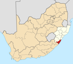
Ugu District Municipality

Last updated
Ugu aka indawo engenamanzi
Ugu CoA.png
Map of South Africa with Ugu highlighted (2011).svg
Location of Ugu District Municipality within KwaZulu-Natal
Coordinates: 30°45′S30°26′E / 30.750°S 30.433°E / -30.750; 30.433
Country South Africa
Province KwaZulu-Natal
Seat Port Shepstone
Local municipalities
Government
[1]
  Type Municipal council
  MayorSikhumbuzo Issac Mqadi
Area
  Total
5,047 km2 (1,949 sq mi)
Population
 (2011) [2]
  Total
722,484
  Density140/km2 (370/sq mi)
Racial makeup (2011)
[2]
   Black African 90.6%
   White 4.9%
   Indian/Asian 3.4%
   Coloured 0.8%
First languages (2011)
[2]
   Zulu 82.7%
   English 8.3%
   Xhosa 4.3%
   Afrikaans 2.1%
  Other2.6%
Time zone UTC+2 (SAST)
Municipal codeDC21

The Ugu District Municipality (Zulu : UMasipala wesiFunda sase Ugu) is one of the 11 districts of the KwaZulu-Natal province of South Africa. Ugu is isiZulu for "coast". It governs the KZN South Coast and its seat is Port Shepstone. The majority of its 722,484 inhabitants spoke isiZulu as of 2011. The district code is DC21.

Contents

The largest towns in the municipality are Port Shepstone, Margate, Umzinto, Scottburgh and Harding.

Geography

The boundaries of the Ugu District Municipality which covers an area of 5866 square kilometres, coincide with the boundaries of the geographical area of the KwaZulu-Natal South Coast. The municipality stretches 112 kilometres along the coast from Scottburgh in the north to Port Edward in the south and Harding in the west (interior). [3]

The municipality is 84% rural and 16% urban which is the pillar of its successful economy. The municipality consists of eighty one (81) municipal wards, which are in its local municipalities, namely Ray Nkonyeni, Umzumbe, Umdoni and Umuziwabantu. The region also includes forty two (42) traditional authorities. [3]

Topography

Being a coastal strip, the topography generally falls towards the coast and is segmented by many water courses (streams/rivers) resulting in numerous hills and valleys as well as very flat areas along the coast.

Mismanagement

In 2020, the Portfolio Committee on Cooperative Governance and Traditional Affairs (Cogta) released a report in which various corruption-related matters in the municipality were addressed. [4] In the wake of the report the municipal manager, D.D. Naidoo, was removed from his post. The municipality is suffering from poor service delivery as a direct consequence of its poor management and defective tender procedures. The water crises is real and the UGU municipality doesn't respond to complaints raised by the residents. Some parts in the UGU district has no has water for 8 months. [4]

Local municipalities

The district contains the following local municipalities:

Local municipalityPopulation%Dominant language
Ray Nkonyeni 308 67537.70% Zulu
Umzumbe 193 76427.52%Zulu
uMuziwabantu 92 32213.11%Zulu
uMdoni 78 8758.85%Zulu

Neighbours

Ugu is surrounded by:

Demographics

The following statistics are from the 2011 census.

Languages

LanguagePopulation%
IsiZulu 588,48382.69%
English 58,8018.26%
IsiXhosa 30,4404.28%
Afrikaans 14,6162.05%
IsiNdebele 7,1911.01%
Setswana 3,4410.48%
Sign language 2,7040.38%
Other 2,1980.31%
Sepedi 1,5580.22%
Sesotho 1,5110.21%
Tshivenda 3190.04%
SiSwati 2290.03%
Xitsonga 2140.03%

Gender

GenderPopulation%
Female383,32353.06%
Male339,16146.94%

Ethnic group

Ethnic groupPopulation%
African654,77390.63%
White35,7234.94%
Indian/Asian24,7113.42%
Coloured6,1230.85%
Other1,1540.16%

Age

AgePopulation%
000 - 00476 00910.80%
005 - 00991 17112.95%
010 - 01494 51113.42%
015 - 01990 36412.84%
020 - 02460 6998.62%
025 - 02949 6857.06%
030 - 03439 5375.62%
035 - 03938 2385.43%
040 - 04432 4514.61%
045 - 04925 9363.68%
050 - 05424 1223.43%
055 - 05919 1632.72%
060 - 06418 8612.68%
065 - 06915 0462.14%
070 - 07413 9761.99%
075 - 0796 9980.99%
080 - 0844 5220.64%
085 - 0891 6310.23%
090 - 0946880.10%
095 - 0992910.04%
100 plus1020.01%

Politics

Election results

Election results for Ugu in the South African general election, 2004.

PartyVotes%
African National Congress 124 92557.64%
Inkhata Freedom Party 59 74027.56%
Democratic Alliance 17 1217.90%
African Christian Democratic Party 3 6781.70%
Minority Front 2 2451.04%
United Democratic Movement 1 7150.79%
Independent Democrats 1 2180.56%
Freedom Front Plus 1 0490.48%
New National Party 8420.39%
Azanian People's Organisation 7680.35%
Pan African Congress 4800.22%
SOPA 4480.21%
United Christian Democratic Party 4240.20%
EMSA 3820.18%
UF 3800.18%
PJC 3490.16%
CDP 2810.13%
TOP 2650.12%
NA 1830.08%
KISS 1550.07%
NLP 1030.05%
Total216 751100.00%

References

  1. "Contact list: Executive Mayors". Government Communication & Information System. Archived from the original on 14 July 2010. Retrieved 22 February 2012.
  2. 1 2 3 "Statistics by place". Statistics South Africa. Retrieved 27 September 2015.
  3. 1 2 "Ugu District Municipality - Home". ugu.gov.za. Retrieved 2020-07-29.
  4. 1 2 "AfriForum se Margate-tak verwelkom verslag oor Ugu Distriksmunisipaliteit". AfriForum. afriforum.co.za. Retrieved 2 December 2020.