Port Edward | |
---|---|
Coordinates: 31°03′00″S30°13′00″E / 31.05000°S 30.21667°E | |
Country | South Africa |
Province | KwaZulu-Natal |
District | Ugu |
Municipality | Ray Nkonyeni |
Area | |
• Total | 24.18 km2 (9.34 sq mi) |
Population (2011) [1] | |
• Total | 4,409 |
• Density | 180/km2 (470/sq mi) |
Racial makeup (2011) | |
• Black African | 30.9% |
• Coloured | 2.7% |
• Indian/Asian | 5.2% |
• White | 60.6% |
• Other | 0.6% |
First languages (2011) | |
• English | 49.6% |
• Afrikaans | 24.0% |
• Xhosa | 11.8% |
• Zulu | 10.8% |
• Other | 3.8% |
Time zone | UTC+2 (SAST) |
PO box | 4295 |
Area code | 039 |
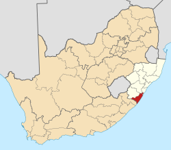
Port Edward is a small resort town situated on the south coast of KwaZulu-Natal in South Africa and lies on the border between KwaZulu-Natal and the Eastern Cape. [2] It is situated on the R61 road (future N2 Wild Coast Toll Route) between Port Shepstone and Lusikisiki.
In 1831 there was a crisis between the settlers in Port Natal (Durban) and Dingane, the Zulu king. Some settlers boarded a ship that was in the harbour and the others, including Henry Francis Fynn and his family, fled down the coast. The Zulu warriors caught up with them where Port Edward is today and massacred the fleeing settlers, which included local tribespeople of Langeni, on a hill called Isandlundlu (in English, shaped like a hut). The place has been known ever since as Tragedy Hill and its slopes are still littered with the bones of the victims.
In 1552, the Portuguese carrack "Sao Joao" ran aground at Port Edward and this is the first time in recorded history that peoples from Europe met peoples from South Africa.
In 1878, the ship "The Ivy" ran aground on Leisure Bay area beach.
In 1925, the area was partly owned by TK Pringle, [3] and he named the inland portion Banner Rest as this was where he wished to "strike his banner". The village was laid out and was named Port Edward in honour of the Prince of Wales, who later became King Edward VIII. [3]
The first holiday cottage in Port Edward was a shack built among the sand dunes in the early days by transport rider Edward Stafford. Unaware of their motility, however, he was surprised and dismayed to see his fine creation swallowed up. The area was subjected to several name changes as property was bought and sold, but the practice came to an end in 1852 when the town of Port Edward was ceremoniously dedicated to the then Prince of Wales. [4]
Port Edward is the southernmost town of KwaZulu-Natal and lies north of the Mtamvuna River which separates KwaZulu-Natal from the Eastern Cape. It is situated approximately 46 kilometres (29 mi) south-west of Port Shepstone by road and 153 kilometres (95 mi) south-west of Durban by road. [5] [6]
The 2011 census divided the main place of Port Edward into 16 “sub places” including: [7]
Port Edward is a tourist resort for seasonal visitors from inland regions of South Africa.
There are many tourist seasons that influence Port Edward but the most significant is the Christmas/ New Year period spanning from early December to mid-January. Port Edward's Silver Beach hosts an annual New Year's Eve party frequented by youths whilst on New Year's Day itself, families populate the beach for continued celebrations.
Holiday accommodation is a particularly important source of income for the region throughout the year.
Beaches in the greater Port Edward area include:
Another main season coincides with the Sardine run natural phenomenon usually occurring from late May to mid-July.
There are various small schools in Port Edward, some consisting of only 50+ children; however the most popular of these schools is Port Edward Primary School.
The 9-hole Port Edward Country Club is the main golf course in Port Edward. Nearby 18-hole golf courses include Wild Coast Sun, San Lameer, Southbroom Golf Club, Margate Country Club and Port Shepstone Country Club which are highly ranked by both Golf Digest and The Compleat Golfer. [22]
The nearest airport is the Margate Airport approximately 32 km north-east of Port Edward. The airport offers one scheduled direct route to Johannesburg operated by CemAir. The nearest international airport is the King Shaka International Airport (KSIA) just north of Durban and is approximately 196 km north-east of Port Edward. KSIA offers regional flights to Southern Africa, intercontinental flights to the Middle East as well as many domestic flights. [23] [24]
The R61 is the main route that passes through Port Edward, connecting Port Shepstone with Mbizana and Mthatha. Izingolweni Road is a rural road connecting Port Edward with the N2 (to Kokstad) in Izingolweni to the north-west.
Margate is a coastal resort town in the KwaZulu-Natal province, about 20 kilometres south-west of Port Shepstone and 127 kilometres south-west of Durban. The river which flows into the sea at Margate is called "Nkhongweni" (place of entreaty) as the original inhabitants of the area were reputed to be so mean resulting in travellers begging for hospitality.
Port Shepstone is a large town situated on the mouth of the Mzimkhulu River, the largest river on the KwaZulu-Natal South Coast of South Africa. It is located halfway between Hibberdene and Margate and is positioned 120 km south of Durban. It serves as the administrative, educational, industrial and commercial centre for southern Natal.
Scottburgh is a coastal resort town located along the south coast of KwaZulu-Natal, South Africa. It situated south of the mouth of the Mpambanyoni River (confuser of birds).
Hibberdene is a small coastal town on the KwaZulu-Natal South Coast in South Africa, approximately 23 km north-east of Port Shepstone and 90 km south-west of Durban and halfway between coastal towns of Scottburgh and Margate.
Umzumbe is a seaside resort situated at the mouth of the Mzumbe River (bad kraal) in KwaZulu-Natal, South Africa. The name of the river is derived from a band of Hlongwa cannibals who occupied the valley. The Hlongwa was almost wiped out by the Zulu king Shaka in 1828.
The R61 is a long provincial route in South Africa that connects Beaufort West with Port Shepstone via Graaff-Reinet, Komani, Mthatha and Port Edward.
The Ugu District Municipality is one of the 11 districts of the KwaZulu-Natal province of South Africa. Ugu is isiZulu for "coast". It governs the KZN South Coast and its seat is Port Shepstone. The majority of its 722,484 inhabitants spoke isiZulu as of 2011. The district code is DC21.
Marburg is a settlement in the Ugu District Municipality in the KwaZulu-Natal province of South Africa, situated approximately 112 kilometres south-west of the city of Durban. Marburg was a Norwegian settlement given the name Marburg for a nearby German mission. The Norwegian founders played a significant role in the development of Marburg and Port Shepstone, which it forms part of today. The British colonial government gave the settlers a free voyage to South Africa and also houses and 100 acres of land. Marburg was the only successful Scandinavian settlement in South Africa.
Mtwalume, also known as Umtalumi, is a settlement in Ugu District Municipality in the KwaZulu-Natal province of South Africa.
Izingolweni or eZinqoleni is a town in Ugu District Municipality in the KwaZulu-Natal province of South Africa. It was founded in the 1870s as a police and administration post. The name comes from the Zulu language word for "place with very shallow holes." Izingolweni also consists of a school called Izingolweni Primary which is rumored that it was built by the community. This very school is the center of excellence in the place. It is very exceptional and produces very fine learners each year.
Southbroom is a coastal village on the South Coast of the KwaZulu-Natal province of South Africa situated approximately halfway between Port Shepstone – 23 km (14 mi) and Port Edward – 18 km (11 mi).
Shelly Beach is a coastal resort town on the South Coast of the KwaZulu-Natal province of South Africa, located approximately halfway between Margate and Port Shepstone.
Trafalgar is a seaside resort village in Ugu District Municipality in the KwaZulu-Natal province of South Africa. Trafalgar is on the north bank of the Mpenjati river which enters the Indian Ocean at the Mpenjati Nature Reserve. The town is located in lush coastal forest, sitting on a small rise overlooking the beach.
Athlone Park is a small coastal suburb located between Durban and Amanzimtoti in KwaZulu-Natal, South Africa. Considered as one of Amanzimtoti’s most sought-after suburbs, Athlone Park forms part of the eThekwini Metropolitan Municipality as a Southern Suburb.
The KwaZulu-Natal South Coast is a region along the southern stretch of coastline of KwaZulu-Natal, South Africa, south of the coastal city of Durban.
Murchison is a peri-urban settlement in the Ugu District Municipality in KwaZulu-Natal, South Africa.
Leisure Bay is a small coastal village located on the Lower South Coast of KwaZulu-Natal in South Africa.
Mobeni is a suburb of Durban in KwaZulu-Natal, South Africa and forms part of the heavily industrialised South Durban Basin, a sub-region south of Durban.
St Michael's-on-Sea is a small seaside village located on the South Coast of KwaZulu-Natal, South Africa, between Uvongo and Shelly Beach.
Izotsha is a small rural settlement on the South Coast of the KwaZulu-Natal province of South Africa, just inland from Shelly Beach and approximately 7 kilometres south-west of Port Shepstone. The name ‘Izotsha’ translates to 'it will burn’ in the Zulu language.