Kelso | |
|---|---|
 Kelso  Kelso | |
| Coordinates: 30°21′37″S30°42′43″E / 30.36028°S 30.71194°E | |
| Country | South Africa |
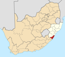
| Province | KwaZulu-Natal |
| District | Ugu |
| Municipality | Umdoni |
| Area | |
• Total | 1.20 km2 (0.46 sq mi) |
| Population (2011) [1] | |
• Total | 425 |
| • Density | 350/km2 (920/sq mi) |
| Racial makeup (2011) | |
| • Black African | 73.3% |
| • Coloured | 0.5% |
| • Indian/Asian | 11.1% |
| • White | 14.9% |
| • Other | 0.2% |
| First languages (2011) | |
| • Zulu | 61.6% |
| • English | 24.4% |
| • Xhosa | 5.1% |
| • Afrikaans | 4.4% |
| • Other | 4.4% |
| Time zone | UTC+2 (SAST) |
| PO box | 4183 |
Kelso is located in the uMdoni Coast region of South Africa facing the Indian Ocean. Kelso is located 65 kilometers south of Durban, the largest city in KwaZulu-Natal. [2]