"},"population_total":{"wt":"366"},"population_as_of":{"wt":"2011"},"population_density_km2":{"wt":"auto\n"},"demographics_type1":{"wt":"Racial makeup (2011)"},"demographics1_footnotes":{"wt":""},"demographics1_title1":{"wt":"[[Bantu peoples of South Africa|Black African]]"},"demographics1_info1":{"wt":"40.2%"},"demographics1_title2":{"wt":"[[Coloureds|Coloured]]"},"demographics1_info2":{"wt":"4.9%"},"demographics1_title3":{"wt":"[[Indian South African|Indian]]/[[Asian South African|Asian]]"},"demographics1_info3":{"wt":"6.0%"},"demographics1_title4":{"wt":"[[White South African|White]]"},"demographics1_info4":{"wt":"48.6%"},"demographics1_title5":{"wt":"Other"},"demographics1_info5":{"wt":"0.3%\n"},"demographics_type2":{"wt":"[[First language]]s (2011)"},"demographics2_footnotes":{"wt":""},"demographics2_title1":{"wt":"[[English language|English]]"},"demographics2_info1":{"wt":"42.2%"},"demographics2_title2":{"wt":"[[Zulu language|Zulu]]"},"demographics2_info2":{"wt":"32.4%"},"demographics2_title3":{"wt":"[[Afrikaans]]"},"demographics2_info3":{"wt":"22.0%"},"demographics2_title4":{"wt":"[[Xhosa language|Xhosa]]"},"demographics2_info4":{"wt":"2.0%"},"demographics2_title5":{"wt":"Other"},"demographics2_info5":{"wt":"1.4%\n\n"},"timezone1":{"wt":"[[South African Standard Time|SAST]]"},"utc_offset1":{"wt":"+2"},"postal_code_type":{"wt":"[[List of postal codes in South Africa|Postal code]] (street)"},"postal_code":{"wt":"4225"},"postal2_code_type":{"wt":"[[Post-office box|PO box]]"},"postal2_code":{"wt":"4225"},"area_code_type":{"wt":"[[Telephone numbers in South Africa|Area code]]"},"area_code":{"wt":"039"}},"i":0}}]}" id="mwBw">Place in KwaZulu-Natal, South Africa
Umzumbe | |
---|---|
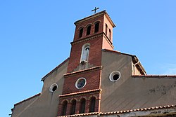
Old St Elmos church in Umzumbe | |
Coordinates: 30°37′30″S30°32′31″E / 30.6249°S 30.5420°E | |
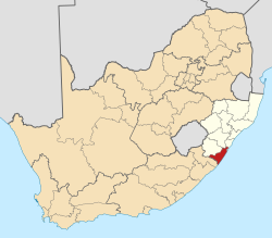
Country | South Africa |
Province | KwaZulu-Natal |
District | Ugu |
Municipality | Ray Nkonyeni |
Main Place | Hibberdene |
Area | |
• Total | 2.21 km2 (0.85 sq mi) |
Population (2011) [1] | |
• Total | 366 |
• Density | 170/km2 (430/sq mi) |
Racial makeup (2011) | |
• Black African | 40.2% |
• Coloured | 4.9% |
• Indian/Asian | 6.0% |
• White | 48.6% |
• Other | 0.3% |
First languages (2011) | |
• English | 42.2% |
• Zulu | 32.4% |
• Afrikaans | 22.0% |
• Xhosa | 2.0% |
• Other | 1.4% |
Time zone | UTC+2 (SAST) |
Postal code (street) | 4225 |
PO box | 4225 |
Area code | 039 |
Umzumbe is a seaside resort situated at the mouth of the Mzumbe River (bad kraal) in KwaZulu-Natal, South Africa. The name of the river is derived from a band of Hlongwa cannibals who occupied the valley. The Hlongwa was almost wiped out by the Zulu king Shaka in 1828.
Umzumbe is situated south of the mouth of the Mzumbe River, from which it takes its name; of Zulu origin, it has been explained as meaning ‘the dangerous river’, ‘the winding river’ and ‘wild bean river’. The form uMzumbe has been approved. [2]
Umzumbe lies on the mouth of the Mzumbe River some 5 km (3 mi) south-west of Hibberdene and lies just north of the small seaside village of Pumula. Furthermore it lies 16 km (9.9 mi) north of Port Shepstone, the administrative centre of the KwaZulu-Natal South Coast and 98 km (61 mi) south-west of the city of Durban. [3] [4]
It lies on the R102 between Hibberdene to the north and Port Shepstone to the south.
Umzumbe has one beach, the Umzumbe Beach which is a Blue Flag Beach. Nearby and larger beaches within the Lower South Coast include Hibberdene, Ramsgate, St Michael's-on-Sea, Uvongo, Margate and Marina Beach. [5] [6]
Another recreational area is the Umzumbe Surf Camp. [7]
Spearfishing is popular in Umzumbe as the Umzumbe point is the most prominent tip south of Hibberdene. It is a prime area for garrick and brusher. [8]
Margate is a coastal resort town in the KwaZulu-Natal province, about 20 kilometres south-west of Port Shepstone and 127 kilometres south-west of Durban. The river which flows into the sea at Margate is called "Nkhongweni" (place of entreaty) as the original inhabitants of the area were reputed to be so mean resulting in travellers begging for hospitality.
Port Shepstone is a large town situated on the mouth of the Mzimkhulu River, the largest river on the KwaZulu-Natal South Coast of South Africa. It is located halfway between Hibberdene and Margate and is positioned 120 km south of Durban. It serves as the administrative, educational, industrial and commercial centre for southern Natal.
Scottburgh is a coastal resort town located along the south coast of KwaZulu-Natal, South Africa. It situated south of the mouth of the Mpambanyoni River (confuser of birds).
Port Edward is a small resort town situated on the south coast of KwaZulu-Natal in South Africa and lies on the border between KwaZulu-Natal and the Eastern Cape. It is situated on the R61 road between Port Shepstone and Lusikisiki.
Harding is a town situated in the Mzimkulwana River valley, Ugu District Municipality of KwaZulu-Natal, South Africa
Hibberdene is a small coastal town on the KwaZulu-Natal South Coast in South Africa, approximately 23 km north-east of Port Shepstone and 90 km south-west of Durban and halfway between coastal towns of Scottburgh and Margate.
Uvongo is a seaside resort town situated along the KwaZulu-Natal South Coast at the mouth of the Vungu River in KwaZulu-Natal, South Africa. Situated 4 kilometres north of Margate, Uvongo is the largest upmarket residential area on the lower South Coast.
The Ugu District Municipality is one of the 11 districts of the KwaZulu-Natal province of South Africa. Ugu is isiZulu for "coast". It governs the KZN South Coast and its seat is Port Shepstone. The majority of its 722,484 inhabitants spoke isiZulu as of 2011. The district code is DC21.
Mtwalume, also known as Umtalumi, is a settlement in Ugu District Municipality in the KwaZulu-Natal province of South Africa.
Southbroom is a coastal village on the South Coast of the KwaZulu-Natal province of South Africa situated approximately halfway between Port Shepstone – 23 km (14 mi) and Port Edward – 18 km (11 mi).
Shelly Beach is a coastal resort town on the South Coast of the KwaZulu-Natal province of South Africa, located more or less halfway between Margate and Port Shepstone.
Munster is a quiet coastal town in Ugu District Municipality in the KwaZulu-Natal province of South Africa.
St Faith’s is a village in the Umzumbe Local Municipality in the KwaZulu-Natal province of South Africa.
Athlone Park is a small coastal suburb located between Durban and Amanzimtoti in KwaZulu-Natal, South Africa and forms part the eThekwini Metropolitan Municipality as a Southern Suburb.
KwaZulu-Natal South Coast is a region along the southern stretch of coastline of KwaZulu-Natal, South Africa, south of the coastal city of Durban.
Murchison is a settlement in the Ugu District Municipality in KwaZulu-Natal, South Africa.
This is a list of seaside resorts in South Africa. These seaside resorts are in the Eastern Cape, KwaZulu-Natal, Northern Cape and Western Cape provinces which are all coastal provinces of South Africa.
Melville is a seaside resort village situated along the South Coast of KwaZulu-Natal, South Africa.
Leisure Bay is a small coastal village located on the Lower South Coast of KwaZulu-Natal in South Africa.
St Michael's-on-Sea is a small seaside village located on the South Coast of KwaZulu-Natal, South Africa, between Uvongo and Shelly Beach.