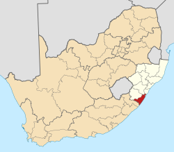
Park Rynie

Last updated

Park Rynie
South Africa KwaZulu-Natal location map.svg
Red pog.svg
Park Rynie
South Africa adm location map.svg
Red pog.svg
Park Rynie
Coordinates: 30°19′S30°44′E / 30.317°S 30.733°E / -30.317; 30.733
Country South Africa
Province KwaZulu-Natal
District Ugu
Municipality Umdoni
Main Place Scottburgh
Area
[1]
  Total7.81 km2 (3.02 sq mi)
Population
 (2011) [1]
  Total3,732
  Density480/km2 (1,200/sq mi)
Racial makeup (2011)
[1]
   Black African 34.8%
   Coloured 5.1%
   Indian/Asian 48.0%
   White 11.5%
  Other0.6%
First languages (2011)
[1]
   English 65.2%
   Zulu 23.7%
   Xhosa 3.7%
   Afrikaans 3.6%
  Other3.8%
Time zone UTC+2 (SAST)
PO box
4182

Park Rynie is a small resort town on the South Coast of KwaZulu-Natal in South Africa. It was established in 1857 and possibly named after Renetta (nicknamed Rynie) Hoets, wife of one of the John Phillip Hoffman, partner in the firm Nosworthy & Co. that bought the original farm for development. There was a whaling station here built during World War I, Park Rynie Whales Ltd. A breakwater, Rocky Bar Pier and a landing ramp were also built.

Contents

Indian South Africans are the single largest population group in Park Rynie.

The main attraction of this town is the quaint beaches. They have an interesting geological and historical value.[ clarification needed ]

Geography

Park Rynie is situated exactly halfway between Durban and Port Shepstone, approximately 63 kilometres (39 mi) south-west of Durban and 63 kilometres (39 mi) north-east of Port Shepstone. Its neighbouring towns include Scottburgh to the north, Pennington to the south, and Umzinto, about 8 km to the west.

Transport

Roads

Park Rynie is situated along the R102 coastal road, connecting north to Scottburgh and Umkomaas and south to Pennington and Hibberdene. The R612 route connects Park Rynie with Umzinto and Ixopo to the west and provides access to the N2 freeway (to Durban and Port Shepstone), which bypasses to the west.

Related Research Articles

<span class="mw-page-title-main">Port Shepstone</span> Coastal town in KwaZulu-Natal, South Africa

Port Shepstone is a large town situated on the mouth of the Mzimkhulu River, the largest river on the KwaZulu-Natal South Coast of South Africa. It is located halfway between Hibberdene and Margate and is positioned 120 km south of Durban. It serves as the administrative, educational, industrial and commercial centre for southern Natal.

<span class="mw-page-title-main">Scottburgh</span> Place in KwaZulu-Natal, South Africa

Scottburgh is a coastal resort town located along the south coast of KwaZulu-Natal, South Africa. It situated south of the mouth of the Mpambanyoni River (confuser of birds).

<span class="mw-page-title-main">Port Edward, South Africa</span> Seaside town in KwaZulu-Natal, South Africa

Port Edward is a small resort town situated on the south coast of KwaZulu-Natal in South Africa and lies on the border between KwaZulu-Natal and the Eastern Cape. It is situated on the R61 road between Port Shepstone and Lusikisiki.

Hibberdene is a small coastal town on the KwaZulu-Natal South Coast in South Africa, approximately 23 km north-east of Port Shepstone and 90 km south-west of Durban and halfway between coastal towns of Scottburgh and Margate.

Isipingo is a town situated 19 kilometres (12 mi) south of Durban in KwaZulu-Natal, South Africa and currently forms part of eThekwini Metropolitan Municipality. The town is named after the Siphingo River, which in turn is thought to be named for the intertwining cat-thorn shrubs (Scutia myrtina) present in the area, or the river's winding course.

Umzinto is a town, located in the South Coast of KwaZulu-Natal, South Africa, approximately 67 kilometres south-west of Durban. It was a sugarcane growing area and the town was set up as the centre for a sugar mill.

<span class="mw-page-title-main">R102 (South Africa)</span> Regional Route in South Africa

The R102 is a Regional Route in South Africa. It is the route designation for all old sections of the N2, thus it is a discontinuous road that resumes in areas where a new N2 has been constructed.

<span class="mw-page-title-main">N2 (South Africa)</span> National road in South Africa

The N2 is a national route in South Africa that runs from Cape Town through George, Gqeberha, East London, Mthatha, Port Shepstone and Durban to Ermelo. It is the main highway along the Indian Ocean coast of the country. Its current length of 2,255 kilometres (1,401 mi) makes it the longest numbered route in South Africa.

<span class="mw-page-title-main">Ugu District Municipality</span> District municipality in KwaZulu-Natal, South Africa

The Ugu District Municipality is one of the 11 districts of the KwaZulu-Natal province of South Africa. Ugu is isiZulu for "coast". It governs the KZN South Coast and its seat is Port Shepstone. The majority of its 722,484 inhabitants spoke isiZulu as of 2011. The district code is DC21.

Kelso is located in the uMdoni Coast region of South Africa facing the Indian Ocean. Kelso is located 65 kilometers south of Durban, the largest city in KwaZulu-Natal.

Umbogintwini is a suburb located approximately 23 km south-west of Durban, in the KwaZulu-Natal province of South Africa and it forms part of the eThekwini Metropolitan Municipality.

Marburg is a settlement in the Ugu District Municipality in the KwaZulu-Natal province of South Africa, situated approximately 112 kilometres south-west of the city of Durban. Marburg was a Norwegian settlement given the name Marburg for a nearby German mission. The Norwegian founders played a significant role in the development of Marburg and Port Shepstone, which it forms part of today. The British colonial government gave the settlers a free voyage to South Africa and also houses and 100 acres of land. Marburg was the only successful Scandinavian settlement in South Africa.

<span class="mw-page-title-main">Mthwalume</span> Place in KwaZulu-Natal, South Africa

Mtwalume, also known as Umtalumi, is a settlement in Ugu District Municipality in the KwaZulu-Natal province of South Africa.

The R612 is a regional route in KwaZulu-Natal, South Africa that connects Park Rynie with Bulwer via Donnybrook, Ixopo, Highflats and Umzinto.

<span class="mw-page-title-main">South Coast (KwaZulu-Natal)</span> Coastal region in KwaZulu-Natal, South Africa

KwaZulu-Natal South Coast is a region along the southern stretch of coastline of KwaZulu-Natal, South Africa, south of the coastal city of Durban.

Prospecton is an industrial suburb located south of Durban in KwaZulu-Natal, South Africa.

Craigieburn is a small town located on the South Coast of KwaZulu-Natal, South Africa and 53 km south-west of Durban.

<span class="mw-page-title-main">Amandawe</span> Township in KwaZulu-Natal Province, South Africa

Amandawe also known as Amandawe Mission, or often informally abbreviated as A.M.A or A.M is a small township in the KwaZulu-Natal South Coast region of South Africa. The area is mostly populated with Black Africans.

References

  1. 1 2 3 4 "Sub Place Park Rynie". Census 2011.