The R612 is a regional route in KwaZulu-Natal, South Africa that connects Park Rynie with Bulwer via Donnybrook, Ixopo, Highflats and Umzinto. [1]
Contents
 | ||||
|---|---|---|---|---|
| Location | ||||
| Country | South Africa | |||
| Highway system | ||||
| ||||
The R612 is a regional route in KwaZulu-Natal, South Africa that connects Park Rynie with Bulwer via Donnybrook, Ixopo, Highflats and Umzinto. [1]
| | ||||
|---|---|---|---|---|
| Location | ||||
| Country | South Africa | |||
| Highway system | ||||
| ||||
Its south-eastern terminus is at an intersection with the R102 in Park Rynie and heads in a westerly direction. It crosses with the N2 at an off-ramp west of Park Rynie and after 6 kilometres it enters Umzinto. After Umzinto, it goes through the hilly rural area of the South Coast where it notably passes through Highflats and heads in a north-westerly direction. It crosses the R56 (to Kokstad and Pietermaritzburg) in Ixopo and after 35 kilometres it goes through Donnybrook before ending at an intersection with the R617, 5 kilometres south of Bulwer. [2] [3] [4] [5]
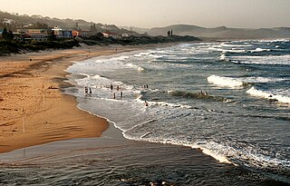
Scottburgh is a coastal resort town located along the south coast of KwaZulu-Natal, South Africa. It situated south of the mouth of the Mpambanyoni River (confuser of birds).

Ixopo, also known as Stuartstown, is a town situated on a tributary of the uMkhomazi River along the R56 highway in the midlands of KwaZulu-Natal, South Africa.
Park Rynie is a small resort town on the South Coast of KwaZulu-Natal in South Africa. It was established in 1857 and possibly named after Renetta Hoets, wife of one of the John Phillip Hoffman, partner in the firm Nosworthy & Co. that bought the original farm for development. There was a whaling station here built during World War I, Park Rynie Whales Ltd. A breakwater, Rocky Bar Pier and a landing ramp were also built.
Umzinto is a town, located in the South Coast of KwaZulu-Natal, South Africa, approximately 67 kilometres (42 mi) south-west of Durban. It was a sugarcane growing area and the town was set up as the centre for a sugar mill.

The R24 is a major East-West provincial route in the Gauteng and North West provinces that links OR Tambo International Airport with Rustenburg via Johannesburg, Krugersdorp and Magaliesburg. The section of the route from OR Tambo International westwards up to a point in Roodepoort is has been named Albertina Sisulu Road since 2013, named after anti-apartheid stalwart Albertina Sisulu.

The R56 is a provincial route in South Africa that connects Middelburg with Pietermaritzburg via Molteno, Maclear and Kokstad. It is co-signed with the N2 between Kokstad and Stafford's Post for 39 kilometres.

The R75 is a provincial route in Eastern Cape, South Africa that connects Graaff-Reinet with Gqeberha via Despatch, Kariega and Jansenville.
The R104 is a regional route in South Africa that is the designation for some of the old sections of roads that were previously the N4, prior to upgrading. It connects Rustenburg in the North West province with eMalahleni in Mpumalanga province via Mooinooi, Hartbeespoort, Pretoria and Bronkhorstspruit. There are two additional sections in Mpumalanga province: a 50km section connecting Middelburg and Wonderfontein and a 17km section passing through Mbombela.

The N2 is a national route in South Africa that runs from Cape Town through George, Gqeberha, East London, Mthatha, Port Shepstone and Durban to Ermelo. It is the main highway along the Indian Ocean coast of the country. Its current length of 2,255 kilometres (1,401 mi) makes it the longest numbered route in South Africa.

Provincial Trunk Highway 3 (PTH 3) is a major provincial highway located in the Canadian province of Manitoba. It runs from the Saskatchewan boundary to the southwest city limits of Winnipeg, where it continues as Winnipeg Route 155. Prior before to the implementation of Winnipeg's City Route System, it extended to Pembina Highway.

William Street is a suburban distributor and one of two major cross-streets in the central business district of Perth, Western Australia. Commencing in western Mount Lawley, its route takes it through the Northbridge café and nightclub district as well as the CBD.
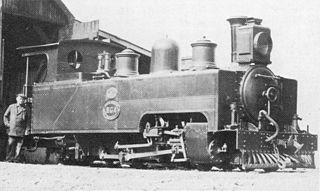
The South African Railways Class NG3 4-6-2T of 1907 was a narrow-gauge steam locomotive from the pre-Union era in the Colony of Natal.

In the early 1900s, 2 ft narrow-gauge railway lines started playing a significant role in South Africa. They facilitated the transport of various agricultural and mineral produce from locations hardly accessible by road. They therefore enabled many communities to become prosperous.
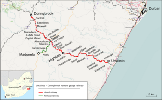
The Umzinto–Donnybrook narrow-gauge railway is a closed 2 ft narrow-gauge railway line in South Africa. It runs from Umzinto to Donnybrook, passing through Highflats and Ixopo, with a branch from Ixopo to Madonela. The line was built in 1908 and was 93 miles (150 km) in length.
The Paton's Country Narrow Gauge Railway (PCNGR) is a 2 ft narrow-gauge heritage railway in KwaZulu-Natal, South Africa.

The uMkhomazi River is a river in KwaZulu-Natal, South Africa.
The R544 is a Regional Route in Mpumalanga, South Africa. It connects Bethal with Kwaggafontein via Witbank (eMalahleni) and Verena.
The R617 is a Regional Route in South Africa that connects Howick with Kokstad via Bulwer, Underberg and Franklin.

The KwaZulu-Natal South Coast is a region along the southern stretch of coastline of KwaZulu-Natal, South Africa, south of the coastal city of Durban.