Kokstad

Last updated
Kokstad
Kokstad City Hall and Victorian Bandstand. (Cast Iron). Also Memorial to Cape Mounted Riflemen & Volunteers, East Griqualand. 1899 -1902. 03.jpg
Kokstad City Hall and Victorian Bandstand. Also visible is the Memorial to Cape Mounted Riflemen & Volunteers, East Griqualand.
South Africa KwaZulu-Natal location map.svg
Red pog.svg
Kokstad
South Africa adm location map.svg
Red pog.svg
Kokstad
Africa location map.svg
Red pog.svg
Kokstad
Coordinates: 30°33′14″S29°25′37″E / 30.55389°S 29.42694°E / -30.55389; 29.42694
Country Flag of South Africa.svg South Africa
Province Flag of the KwaZulu-Natal Province.png  KwaZulu-Natal
District Harry Gwala
Municipality Greater Kokstad
Area
[1]
  Total51.57 km2 (19.91 sq mi)
Elevation
1,302 m (4,272 ft)
Population
 (2011) [1]
  Total51,561
  Density1,000/km2 (2,600/sq mi)
Racial makeup (2011)
[1]
   Black African 84.2%
   Coloured 5.9%
   Indian/Asian 3.8%
   White 5.8%
  Other0.3%
First languages (2011)
[1]
   Xhosa 72.9%
   English 9.1%
   Afrikaans 6.8%
   Zulu 5.8%
  Other5.5%
Time zone UTC+2 (SAST)
Postal code (street)
4700
PO box
4700
Area code 039

Kokstad is a town in the Harry Gwala District Municipality of KwaZulu-Natal Province, South Africa. Kokstad is named after the Griqua chief Adam Kok III who settled here in 1863. Kokstad is the capital town of the East Griqualand region, as it is also the biggest town in this region. It was built around Mount Currie, a local mountain range, by the city's founder Adam Kok III, for whom the town is named. Stad is the Dutch and Afrikaans word for "city".

Contents

The town is built on the outer slopes of the Drakensberg and is 1,302 m above sea level. Behind it Mount Currie rises to a height of 2,224 m.

It is a centre for cheese and other dairy products.

Kokstad has the N2 Highway south of the town's CBD. The R56 leads from Kokstad to Cedarville (45 km), Matatiele (68 km) and Maluti leading to the border of Lesotho. The R617 is also a bisecting route leading from Kokstad to Underberg (109 km), Swartberg (41 km) and Bulwer (147 km).

The N2, the national route, leads from Kokstad to the east to Port Shepstone (175 km), Durban (380 km) and to the south Mount Ayliff (57 km), Mthatha (180 km), East London (419 km) and Qonce (447 km).

Kokstad is 10 km from the Eastern Cape border on the N2.

The majority of residents can speak IsiXhosa as well as IsiZulu.

Kokstad has no rural villages to date. It is a farming community with majority of its countryside land being cattle farms or residential farms.

History

In 1820 the Griqua tribe which lived in Griquatown (in central South Africa) split and under the leadership of Adam Kok III, descendant of the former cook who established the tribe, one section first moved to Philippolis (southern Free State). In 1861 several hundred Griquas moved across the Drakensberg down the Ongeluks Nek to the vicinity of modern Kokstad. They moved because of the growing confrontation they faced with the Voortrekkers who had moved north of the Orange River to escape the laws of the British. The Voortrekkers, largely Dutch, secured leases over Griqua land and then refused to return the land at the end of the lease. The Big Hole of Kimberley was at the centre of controversy over one such lease.

The Griquas were forced to travel over the Drakensberg into a region earlier devastated by the great Zulu King, Shaka—thus its name "Nomansland". By the time the Griquas arrived in their new promised land eighteen months later they were exhausted and most of their livestock had perished. The impoverished Griquas named the mountain where they settled Mount Currie after Sir Walter Currie who gave support to their effort to settle here. Once settled their leader, Adam Kok, renamed their new land East Griqualand. Every male Griqua who settled in East Griqualand was able to secure a 3,000 acres (1,200 ha) farm, but most of them sold their land cheaply to white settlers and squandered their money. The Rev William Dower in his 1902 book The Early Annals of Kokstad describes in great detail how cheaply the Griqua gave their farms away. [2]

St Patricks Catholic Cathedral Catholic Church, Kokstad.jpg
St Patricks Catholic Cathedral

When, in 1869, the Reverend William Dower was asked by the Griqua to establish a mission, he agreed on condition that they resettle in a more suitable place on the banks of the Mzimhlava river.

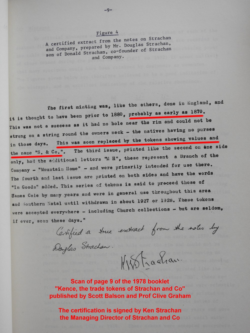
Two prominent European settlers George Brisley and Donald Strachan played a major role in the early development of Kokstad and East Griqualand: their trading store, Strachan and Co, in 1874 introduced South Africa's first indigenous currency—a set of trade tokens which circulated across a wide region, covering an area the size of Ireland.

Confirmation that the Strachan and Co coins circulated as money in the region at this time comes from the local Standard Bank at Kokstad [3] and the managing director of Strachan and Co. [4]

In 1878 East Griqualand came into the possession of Cape Colony. The first hotel in Kokstad, The Royal, was opened by an African-American who also started a newspaper (the Kokstad Advertiser) in 1881. Kokstad became a municipality in 1892. In 1904 the population was recorded at 2903 whom a third were Griquas. The town was transferred to Natal province in 1978. Today the population of Kokstad lies at just over 50,000 people. [5]

Cultural assets

Stemming from a relatively old farming community, Kokstad rose from the lands beneath Mount Currie. Many old buildings and monuments have been erected that are now considered to be National Heritage Sites.

Attractions

The area is popular for its many rivers and dams that provide ample opportunity for trout fishing and hiking possibilities. There are three reserves, Mount Currie, Wilfred Bauer and the Mountain Lake Nature Reserve. [12] These have camping and picnic spots. Among these reserves, the Mountain Lake Nature Reserve contains paths that provide sightseeing walks, as well as over 220 species of birds. [13] The Mount Currie reserve is filled with history. On the site stands a historic laager site surrounded by graves of early pioneers and a monument pays homage to Boy Scouts who died during the First World War in East Africa.

The area's many dams provide multiple forms of use. Crystal Springs Dam provides many boating and angling opportunities. The dam is fed by the pure water of Crystal Springs, the main source of Kokstad's water supply. In 1924, William Mortimer Mail (b. 16 November 1885) was to take-up an appointment as the Kokstad Town Engineer, Arguably, Mail's most notable achievement was improvement to Kokstad's drinking water, which at the time of his arrival, was drawn from a mountain stream. Whenever it rained, it became heavily stained. After identifying a suitable spring further down the mountain (Crystal Springs), he first conducted a series of water flow rate metering, to establish there was sufficient flow to meet the town's needs. Once it had been proven there was sufficient flow, Mail then oversaw design and construction of a new water treatment plant. The new plant provided crystal clear water to Kokstad, which helped the town grow and flourish.

In addition to supplying drinking water to the town, the Crystal Spring Dam has become an attraction for both the Kokstad residents, and tourists to the area. There are three rural schemes located in nearby Swartberg, Franklin and Kransdraai, which meet the RDP level of service. [14]

Infrastructure and schooling

Kokstad has many primary and secondary schools, as well as a tertiary institution college. Some of the main schooling institutions are as follows:

Kokstad also has two main hospitals that service the surrounding areas:

Coats of arms

Municipal (1)

By 1931, the Kokstad municipal council had assumed a pseudo-heraldic "coat of arms" depicting a landscape with Mount Currie in the background, ears of wheat, and a tree, and the motto Concilio et animis. [21]

Municipal (2)

A proper coat of arms was designed by Ivan Mitford-Barberton in the late 1950s. It was registered with the Cape Provincial Administration in October 1960 [22] and at the Bureau of Heraldry in July 1979.

The arms were : Per fess Gules and Or, in chief, dexter a Griqua hunter statant holding in his dexter hand a slain buck and in his sinister hand a rifle, sinister a lion statant, all Or; in base, below a yoke the barrel of a cannon palewise, all Sable; the whole within a bordure compony of 40 pieces Argent and Sable. In layman's terms, the shield was divided horizontally into red and gold, the upper half depicting a Griqua hunter holding a slain buck and a rifle and facing a lion, and the lower half a yoke above an upright black cannon barrel, the whole design surrounded by a border divided into forty sections alternately silver and black.

The crest was a cock's head issuing from a golden eastern crown, and the motto was Pro rege lege et grege.

Literature

Notable people associated with Kokstad

Related Research Articles

<span class="mw-page-title-main">Natal (province)</span> Province of South Africa, 1910 to 1994

The Province of Natal, commonly called Natal, was a province of South Africa from May 1910 until May 1994. Its capital was Pietermaritzburg. During this period rural areas inhabited by the black African population of Natal were organized into the bantustan of KwaZulu, which was progressively separated from the province, becoming partially autonomous in 1981. Of the white population, the majority were English-speaking people of British descent, causing Natal to become the only province to vote "No" to the creation of a republic in the referendum of 1960, due to very strong monarchist, pro-British Commonwealth, and anti-secessionist sentiment. In the latter part of the 1980s, Natal was in a state of violence between the Inkatha Freedom Party and the African National Congress, with violence subsiding soon after the first non-racial election in 1994.

<span class="mw-page-title-main">KwaZulu-Natal</span> Province in South Africa

KwaZulu-Natal is a province of South Africa that was created in 1994 when the Zulu bantustan of KwaZulu and Natal Province were merged. It is located in the southeast of the country, with a long shoreline on the Indian Ocean and sharing borders with three other provinces and the countries of Mozambique, Eswatini and Lesotho. Its capital is Pietermaritzburg, and its largest city is Durban. It is the second-most populous province in South Africa, with slightly fewer residents than Gauteng.

<span class="mw-page-title-main">Griqua people</span> Southern African ethnic group

The Griquas is a subgroup of mixed race heterogeneous former Khoe-speaking nations in Southern Africa with a unique origin in the early history of the Dutch Cape Colony. Under apartheid, they were given a special racial people classification under the broader category of "Coloured". They are Cape Coloureds who participated in the Great Trek, forming "Griqua States".

<span class="mw-page-title-main">Griqualand West</span> Area of central South Africa

Griqualand West is an area of central South Africa with an area of 40,000 km2 that now forms part of the Northern Cape Province. It was inhabited by the Griqua people – a semi-nomadic, Afrikaans-speaking nation of mixed-race origin, who established several states outside the expanding frontier of the Cape Colony. It was also ancestral home to the Tswana and Khoisan peoples.

<span class="mw-page-title-main">Griqualand East</span> Former 19th-century country

Griqualand East, officially known as New Griqualand, was one of four short-lived Griqua states in Southern Africa from the early 1860s until the late 1870s and was located between the Umzimkulu and Kinira Rivers, south of the Sotho Kingdom.

<span class="mw-page-title-main">Port Shepstone</span> Coastal City in KwaZulu-Natal, South Africa

Port Shepstone is a large town situated on the mouth of the Mzimkhulu River, the largest river on the KwaZulu-Natal South Coast of South Africa. It is located halfway between Hibberdene and Margate and is positioned 120 km south of Durban. It serves as the administrative, educational, industrial and commercial centre for southern Natal.

<span class="mw-page-title-main">Newcastle, KwaZulu-Natal</span> Place in KwaZulu-Natal, South Africa

Newcastle is the third-largest city in the province of KwaZulu-Natal, South Africa and is the province's industrial centre. The city has four industrial areas. Newcastle is known as the "New City" The majority of its citizens reside in Newcastle East in the main townships of Madadeni and Osizweni, with the balance residing in Newcastle West. Set at the foothills of the northern KwaZulu-Natal Drakensberg Mountains, Newcastle is located in the northwest corner of the province along the Ncandu River.

<span class="mw-page-title-main">Himeville</span> Place in KwaZulu-Natal, South Africa

Himeville is a small village/town situated in the foothills of the picturesque Southern Drakensberg, KwaZulu-Natal, South Africa, approx 130 km from Pietermaritzburg. It is a landmark en route to the world-famous Sani Pass and the uKhahlamba Drakensberg Park. Himeville is the closest town to the Sani Pass which links the town with Mokhotlong in Lesotho.

Umzinto is a town, located in the South Coast of KwaZulu-Natal, South Africa, approximately 67 kilometres south-west of Durban. It was a sugarcane growing area and the town was set up as the centre for a sugar mill.

<span class="mw-page-title-main">Philippolis</span> Place in Free State, South Africa

Philippolis is a town in the Free State province of South Africa. The town is the birthplace of many South African celebrities including the writer and intellectual Sir Laurens van der Post, actress Brümilda van Rensburg and Springboks rugby player Adriaan Strauss. It is regarded as one of the first colonial settlements in the Free State.

<span class="mw-page-title-main">N2 (South Africa)</span> National road in South Africa

The N2 is a national route in South Africa that runs from Cape Town through George, Gqeberha, East London, Mthatha, Port Shepstone and Durban to Ermelo. It is the main highway along the Indian Ocean coast of the country. Its current length of 2,255 kilometres (1,401 mi) makes it the longest numbered route in South Africa.

<span class="mw-page-title-main">Adam Kok III</span> Griqua leader (1811–1875)

Adam Kok III was a leader of the Griqua people in South Africa.

<span class="mw-page-title-main">Midlands of KwaZulu-Natal</span>

The KwaZulu-Natal midlands is an inland area of KwaZulu-Natal, South Africa that starts from Pietermaritzburg and ends before the Drakensberg mountain range.

<span class="mw-page-title-main">Matatiele Local Municipality</span> Local municipality in Eastern Cape, South Africa

Matatiele Municipality is a local municipality within the Alfred Nzo District Municipality, in the Eastern Cape province of South Africa. It adjoins Lesotho to the north, Elundini to the south-west, and Greater Kokstad to the east and its 4,352 km² makes the Matatiele Municipality largest of four municipalities in the district at almost half of its geographical area. According to the South African National Census of 2011, its 203,483 residents and 49,527 households makes Matatiele Municipality the second largest populated area in the Alfred Nzo District Municipality behind Mbizana.

<span class="mw-page-title-main">Greater Kokstad Local Municipality</span> Local municipality in KwaZulu-Natal, South Africa

Greater Kokstad Municipality is a local municipality within the Harry Gwala District Municipality, in the KwaZulu-Natal province of South Africa. Kokstad is derived from Dutch, meaning "town of Kok". It was named after Adam Kok III.

<span class="mw-page-title-main">Griqualand-East Commando</span> Military unit

Griqualand East Commando was a light infantry regiment of the South African Army. It formed part of the South African Army Infantry Formation as well as the South African Territorial Reserve.

<span class="mw-page-title-main">South African Polo Association</span>

The South African Polo Association(SAPA) is the governing body for the sport of polo in South Africa. It is affiliated with the Federation of International Polo (FIP) and the Hurlingham Polo Association.

<span class="mw-page-title-main">South Coast (KwaZulu-Natal)</span> Coastal region in KwaZulu-Natal, South Africa

KwaZulu-Natal South Coast is a region along the southern stretch of coastline of KwaZulu-Natal, South Africa, south of the coastal city of Durban.

Ntsikeni Nature Reserve, in Griqualand East, is the largest wetland and one of the highest above sea level in South Africa.

<span class="mw-page-title-main">North Coast (KwaZulu-Natal)</span> Coastal region in KwaZulu-Natal, South Africa

The KwaZulu-Natal North Coast, better known as the North Coast is a coastal region north of Durban in KwaZulu-Natal, South Africa. It stretches from Zinkwazi Beach in the north to Zimbali near Ballito in the south. The coastal region is governed by the KwaDukuza Local Municipality, forming part of the iLembe District Municipality.

References

  1. 1 2 3 4 "Main Place Kokstad". Census 2011.
  2. Dower, William (1902). The Early Annals of Kokstad and Griqualand East. Port Elizabeth: Kemsley.
  3. "Standard Bank 125th Anniversary brochure in PDF form - see 2nd page" (PDF). Retrieved 2014-06-17.
  4. "Ken Strachan Managing Director of Strachan and Co confirm date of 1874" . Retrieved 2014-06-17.
  5. "Census 2011 — Main Place "Kokstad"". Census2011.adrianfrith.com. Retrieved 2015-10-16.
  6. "Adam Hoek, Historical Religious Cultural Assets - Tourism KwaZulu-Natal". Zulu.org.za. Retrieved 2015-10-16.
  7. "Bandstand, Historical Religious Cultural Assets - Tourism KwaZulu-Natal". Zulu.org.za. Retrieved 2015-10-16.
  8. "Boy Scouts Monument, Historical Religious Cultural Assets - Tourism KwaZulu-Natal". Zulu.org.za. Retrieved 2015-10-16.
  9. "Cape Mounted Rifles Monument, Historical Religious Cultural Assets - Tourism KwaZulu-Natal". Zulu.org.za. Retrieved 2015-10-16.
  10. "East Griqualand Museum And Community Tourism Info Center, Historical Religious Cultural Assets - Tourism KwaZulu-Natal". Zulu.org.za. Retrieved 2015-10-16.
  11. "East Griqualand - Historical, Religious & Cultural Assets - Tourism KwaZulu-Natal". Zulu.org.za. Retrieved 2015-10-16.
  12. "Out & About Attractions / Explore: Crystal Springs Dam, Chapel, Mount Currie", Greater Kokstad Municipality, archived from the original on 22 November 2013
  13. "Mount Currie Nature Reserve". Sa-venues.com. Retrieved 2015-10-16.
  14. "Kokstad". Sa-venues.com. Retrieved 2015-10-16.
  15. "Home". Kokstadjuniorschool.co.za. Retrieved 2015-10-16.
  16. "Kokstad College". Kokstad College. Retrieved 2015-10-16.
  17. "St Patrick's College". Stpatrickscollege.co.za. Retrieved 2015-10-16.
  18. "Home Page | Esayidi TVET".
  19. "Home". Kokstad Private Hospital. Archived from the original on 2015-11-25. Retrieved 2015-10-16.
  20. "E.G.Usher Memorial Hospital". Kznhealth.gov.za. 2015-05-20. Retrieved 2015-10-16.
  21. The arms were depicted on a title=Category:UTC_South_African_town_arms cigarette card issued in 1931.
  22. Cape of Good Hope Official Gazette 3052 (28 October 1960).