
KwaZulu-Natal is a province of South Africa that was created in 1994 when the Zulu bantustan of KwaZulu and Natal Province were merged. It is located in the southeast of the country, enjoying a long shoreline beside the Indian Ocean and sharing borders with three other provinces, and the countries of Mozambique, Eswatini and Lesotho. Its capital is Pietermaritzburg, and its largest city is Durban. It is the second-most populous province in South Africa, with slightly fewer residents than Gauteng.

Mfecane, also known by the Sesotho name Difaqane or Lifaqane, was a period of widespread chaos and warfare among indigenous ethnic communities in southern Africa during the period between 1815 and about 1840.
The Zulu Civil War or Ndwandwe–Zulu War of 1817–1819 was a war fought between the expanding Zulu Kingdom and the Ndwandwe tribe in South Africa.

Babanango is a small town located about 58 kilometers north-west of Melmoth in the KwaZulu-Natal Province of South Africa. Founded in 1904, the town is takes its name from the nearby stream and mountain.
Pomeroy a small town in KwaZulu-Natal, South Africa.
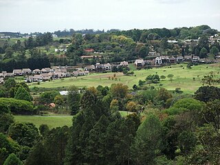
Botha's Hill is a small town outside Hillcrest in KwaZulu-Natal, South Africa. It remains a peaceful beautiful hill where regular country style food and craft markets are held. It is the gateway to the Valley of a Thousand Hills. Kearsney College moved to Botha's Hill in 1939. Alan Paton, a famous author who wrote novels such as Cry, the Beloved Country and Too Late the Phalarope moved here and resided here until his death on the 12th of April, 1988.

Harry Gwala is one of the 11 districts of KwaZulu-Natal province of South Africa. The seat of Harry Gwala is Ixopo. The majority of its 298 392 people speak IsiZulu. The district code is DC43. In November 2015, Sisonke District's name was changed to Harry Gwala District, in honor of African National Congress leader Harry Gwala.

Blood River is situated in KwaZulu-Natal, South Africa. This river has its sources in the hills south-east of Utrecht; leaving the highlands it is joined by two important tributaries that originate in the Schurveberg, after which it flows meandering through a sandy plain. The Blood River is a tributary of the Buffalo River, which is a tributary of the Tugela River which it joins from the north-east.

Umhlanga is an affluent residential, commercial and resort town north of Durban on the coast of KwaZulu-Natal, South Africa. It is part of the eThekwini Metropolitan Municipality, created in 2000, which includes the greater Durban area. The name means "place of reeds" in the Zulu language, and the correct pronunciation of "hl" in Umhlanga is similar to the Welsh "ll". It is bordered by Durban North to the south and Mt Edgecombe to the west.

The Kingdom of Zulu, sometimes referred to as the Zulu Empire or the Kingdom of Zululand, was a monarchy in Southern Africa that extended along the coast of the Indian Ocean from the Tugela River in the south to Pongola River in the north.

Kampala Hill, commonly referred to as Old Kampala, is a hill in the center of Kampala, Uganda's capital and largest city.
Umbogintwini is a town near Durban in KwaZulu-Natal, South Africa. Its post office received the corrected name in 1997. It is best known for the industrial complex which has Acacia, Chemical Initiatives and Sammar warehouses.
Impendle is a town in Umgungundlovu District Municipality in the KwaZulu-Natal province of South Africa.
Nquthu is a town in Umzinyathi District Municipality in the KwaZulu-Natal province of South Africa.
Umzimkhulu is a town in Harry Gwala District Municipality in the KwaZulu-Natal province of South Africa.

eThekwini Metropolitan Municipality is a metropolitan municipality created in 2000, that includes the city of Durban, South Africa and surrounding towns. eThekwini is one of the 11 districts of KwaZulu-Natal province of South Africa. The majority of its 3,442,361 people speak Zulu. It was formed from seven formerly independent local councils and tribal land.
Ndwedwe is a town in Ilembe District Municipality in the KwaZulu-Natal province of South Africa.
Cato Ridge is a town in the KwaZulu-Natal province of South Africa. Organisationally and administratively it is included in the Ethekwini Metropolitan Municipality as a suburb of the Outer West region.

Umbumbulu is a town in the EThekwini Metropolitan Municipality in the KwaZulu-Natal province of South Africa.
Talana is a village 5 km east of Dundee on the route between Vryheid and Glencoe. The name is Zulu and derives from the shelf, made of itala grass, around the central pole in a Zulu chief's home. Amulets, precious items and valuables were placed on this Talana Shelf. Hence the name means "the place where treasures are kept."


