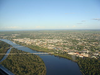
Bundaberg is a city in the Bundaberg Region, Queensland, Australia, and is the tenth largest city in the state. Bundaberg's regional area has a population of 70,921, and is a major centre of the Wide Bay–Burnett geographical region. The Bundaberg central business district is situated along the southern bank of the Burnett River, about 20 km (12 mi) from its mouth at Burnett Heads, and flows into the Coral Sea. The city is sited on a rich coastal plain, supporting one of the nation's most productive agricultural regions. The area of Bundaberg is the home of the Taribelang-Bunda peoples. Popular nicknames for Bundaberg include "Bundy" and "Rum city". The demonym of Bundaberg is Bundabergian.
Volusia County is located in the east-central part of the U.S. state of Florida, stretching between the St. Johns River and the Atlantic Ocean. As of the 2020 census, the county was home to 553,543 people, an increase of 11.9% from the 2010 census. It was founded on December 29, 1854, from part of Orange County, and was named for the community of Volusia, located in northwestern Volusia County. Its first county seat was Enterprise. Since 1887, its county seat has been DeLand.

Sunshine Coast is a peri-urban region in South East Queensland, Australia. It is the district defined in 1967 as "the area contained in the Shires of Landsborough, Maroochy and Noosa, but excluding Bribie Island". Located 100 km (62 mi) north of the centre of Brisbane in South East Queensland, on the Coral Sea coastline, its urban area spans approximately 60 km (37 mi) of coastline and hinterland from Pelican Waters to Tewantin.

Lambayeque is a department and region in northwestern Peru known for its rich Moche and Chimú historical past. The region's name originates from the ancient pre-Inca civilization of the Lambayeque. It is the second-smallest department in Peru after Tumbes, but it is also its most densely populated department and its eighth most populous department.

The Tweed River is a river situated in the Northern Rivers district of New South Wales, Australia. From the middle reaches of its course, the state boundary between New South Wales and Queensland is located approximately 10 kilometres (6.2 mi) north.
The Thumb is a region and a peninsula of the U.S. state of Michigan, so named because the Lower Peninsula is shaped like a mitten. The Thumb area is generally considered to be in the Central Michigan region, east of the Tri-Cities and north of Metro Detroit. The region is also branded as the Blue Water Area.

The Florida Panhandle is the northwestern part of the U.S. state of Florida; it is a strip of land roughly 200 miles (320 km) long and 50 to 100 miles wide, lying between Alabama on the north and the west, Georgia on the north, and the Gulf of Mexico to the south. Its eastern boundary is arbitrarily defined. In terms of population, major communities include Tallahassee, Pensacola, and Panama City.

Port Shepstone is a large town situated on the mouth of the Mzimkhulu River, the largest river on the KwaZulu-Natal South Coast of South Africa. It is located halfway between Hibberdene and Margate and is positioned 120 km south of Durban. It is the administrative, educational and commercial centre for southern Natal.
Scottburgh is a coastal resort town located on the south coast of KwaZulu-Natal, South Africa. It situated on the mouth of the Mpambanyoni River (confuser of birds). Neighbouring towns include Pennington, Renishaw, Freeland Park, Umkomaas, Sezela, Bazley, Amahlongwa, Amandawe Mission, Clansthal, Park Rynie and Dududu.

Pennington is a small coastal town on the south coast of KwaZulu-Natal, South Africa. Apart from a large sugarcane and dairy farming industry, it also hosts scores of holiday makers who flock to the seaside during the December holidays.
Isipingo is a town situated 19 kilometres (12 mi) south of Durban in KwaZulu-Natal, South Africa and currently forms part of eThekwini Metropolitan Municipality. The town is named after the Siphingo River, which in turn is thought to be named for the intertwining cat-thorn shrubs (Scutia myrtina) present in the area, or the river's winding course.
Sezela is a small town on the mouth of iSezela River in KwaZulu-Natal, South Africa. It is notable for its large sugar mill. The river and the town are named after a crocodile. In 1828, the Zulu king, Shaka, hunted down a man-eating crocodile here. The crocodile was called iSezela meaning the one who finds by smell, for it was said that the crocodile hunted like a wild dog following a trail. The friendly town of iSezela can be found 78.7 km south of Durban.

William Neal Gillies was an Australian politician who served as Labor Premier of Queensland from 26 February 1925 to 22 October 1925.
Pleasure Island is a coastal barrier island in Southeastern North Carolina, United States, just south of the City of Wilmington. Pleasure Island is located within Federal Point Township, in New Hanover County. The coastal resort towns of Carolina Beach and Kure Beach, as well as the annexed communities of Wilmington Beach and Hanby Beach are located on the island. The southern end of Pleasure Island was separated from Bald Head Island by Corncake Inlet until the inlet was shoaled and closed in 1998 by Hurricane Bonnie; thus Pleasure Island and Bald Head Island are no longer separate islands.

Douglas Dummett (1806–1873) was a plantation owner who served as a member of the Legislative Council of the Territory of Florida representing St. Johns County in 1843, and a member of the Florida House of Representatives representing Mosquito County in 1845. He was instrumental in developing the Indian River Citrus industry in Florida.

U.S. Sugar Corporation is a privately owned agricultural business based in Clewiston, Florida. The company farms over 230,000 acres of land in the counties of Hendry, Glades, Martin and Palm Beach. It is the largest producer of sugar cane in the United States by volume, producing over 700,000 tonnes per year. The company is also a large producer of refined sugar, sweet corn and oranges.
Okeelanta is an unincorporated community in Palm Beach County, Florida, United States, located approximately 4 miles (7 km) south of South Bay on U.S. Route 27 at County Road 827. It was originally developed as a planned community in the 1910s, but had effectively disappeared by the end of the 1920s. The name is a portmanteau of Lake Okeechobee and Atlantic Ocean.
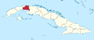
Mayabeque Province is one of two new provinces created from the former La Habana Province, whose creation was approved by the Cuban National Assembly on August 1, 2010, the other being Artemisa Province. The new provinces came in to existence on January 1, 2011.

St Saviour's Anglican Church is a heritage-listed former church building at 26 Hynes Street, South Johnstone, Cassowary Coast Region, Queensland, Australia. It was built from 1938 to 1939 by Mose Romano. It was added to the Queensland Heritage Register on 24 September 2004.

Barron is a suburb of Cairns in the Cairns Region, Queensland, Australia. In the 2016 census Barron had a population of 42 people.


