Shelly Beach, South Africa

Last updated
Shelly Beach
Marine Dr, Shelly Beach.jpg
Shelly Beach CBD
South Africa KwaZulu-Natal location map.svg
Red pog.svg
Shelly Beach
South Africa adm location map.svg
Red pog.svg
Shelly Beach
Coordinates: 30°47′53″S30°24′36″E / 30.798°S 30.410°E / -30.798; 30.410
Country South Africa
Province KwaZulu-Natal
District Ugu
Municipality Ray Nkonyeni
Main Place Margate
Area
[1]
  Total5.37 km2 (2.07 sq mi)
Population
 (2011) [1]
  Total2,577
  Density480/km2 (1,200/sq mi)
Racial makeup (2011)
[1]
   Black African 29.3%
   Coloured 1.9%
   Indian/Asian 8.5%
   White 60.1%
  Other0.2%
First languages (2011)
[1]
   English 51.8%
   Afrikaans 21.8%
   Zulu 17.0%
   Xhosa 6.0%
  Other3.5%
Time zone UTC+2 (SAST)
Postal code (street)
4265
PO box
4265

Shelly Beach is a coastal resort town on the South Coast of the KwaZulu-Natal province of South Africa, located more or less halfway between Margate (8.5 km) and Port Shepstone (7.1 km). [2] [3]

Contents

Geography

Shelly Beach is situated between the Zotsha Creek to the north, the Mhlangeni River to the south and the R61 freeway to the west. Its neighbouring areas are Oslo Beach to the north and St Michael’s-on-Sea and Uvongo to the south.

Economy

Economic Development

The opening of Shelly Centre in 1985 placed Shelly Beach as a prime shopping destination on the KZN South Coast [4] followed by the developments of Southcoast Mall in 2005, [5] Shelly Beach Business Park in 2007, [6] the Shelly Beach Day Hospital (now a 24-hour hospital) in August 2010 [7] and the reopening of McDonald's in Shelly Beach in 2021 since the 1990s. Today Shelly Beach has become the gateway to shopping in the Lower South Coast, host to the two largest malls in the region, namely Shelly Centre and Southcoast Mall.

Retail

The area along Marine Drive is Shelly Beach’s main commercial area, lined with a number of local shops, car dealerships, restaurants, and shopping centres such as Shelly Centre (the largest shopping centre on the South Coast) and Shelly Boulevard. Southcoast Mall, situated on the western outskirts, is another significant shopping centre in Shelly Beach, ranking as the second largest one on the South Coast. [8] [9]

Tourism

Beaches

Shelly Beach is host to two beaches along its coastline, namely Shelly Beach and Windsor on Sea Beach.

The name "Shelly Beach" refers to the many shells on the beaches in which there are. Here, the finest miniature pink lady shells can be found among many other varieties.

Hotels

Hotel Metropole 1961 1961 Metropole.jpg
Hotel Metropole 1961

Snorkelling & diving

Shelly Beach boasts numerous popular diving and snorkelling sites, where the most spectacular varieties of tropical fish, sharks, corals as well as mystical underwater caves can be discovered. These popular sites include Potato Reef, The Caves, Deep Salmon, Arena Reef, Bo Boyi Reef, and Adda Reef. [10]

Infrastructure

Healthcare

Private healthcare

Established on August 2010 as the Shelly Beach Day Hospital, the Shelly Beach Hospital is the sole hospital serving Shelly Beach. Owned by Shelly Health Consortium (Pty) Ltd, it is a private hospital operating 24-hour emergency services. The hospital is located on Izotsha Road, opposite Southcoast Mall. [11]

Public healthcare

Shelly Beach Clinic is a government-funded municipal clinic operated by the Ugu District Municipality. For public hospitals, residents of Shelly Beach normally use the Port Shepstone Regional Hospital. [12]

Roads

Shelly Beach straddles along the R620 (Marine Drive) connecting Port Shepstone to the north with Uvongo to the south. The town also lies just off the R61 highway (future N2 Wild Coast Toll Route) between Port Shepstone and Port Edward. Running north-west, Izotsha Road connects the town with Izotsha to the north-west and Gamalakhe to the west (via the P200).

Tolling

The R61, forming part of the South Coast Toll Route, involves the payment of toll at the toll booths of the Izotsha Ramp Toll Plaza, situated on the off and on-ramps of the Izotsha Road interchange (Exit 39). Traffic arriving from the north to turn off at exit 39 and traffic joining the R61 S from Izotsha Road must pass through the respective ramp plazas. The R620 to Margate and Port Shepstone serves as the untolled alternative route to the R61.

Related Research Articles

<span class="mw-page-title-main">Margate, South Africa</span> Resort town in KwaZulu-Natal, South Africa

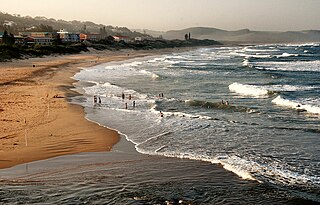
Margate is a coastal resort town in the KwaZulu-Natal province, about 20 kilometres south-west of Port Shepstone and 127 kilometres south-west of Durban. The river which flows into the sea at Margate is called "Nkhongweni" (place of entreaty) as the original inhabitants of the area were reputed to be so mean resulting

<span class="mw-page-title-main">Port Shepstone</span> Coastal town in KwaZulu-Natal, South Africa

Port Shepstone is a large town situated on the mouth of the Mzimkhulu River, the largest river on the KwaZulu-Natal South Coast of South Africa. It is located halfway between Hibberdene and Margate and is positioned 120 km south of Durban. It serves as the administrative, educational, industrial and commercial centre for southern Natal.

<span class="mw-page-title-main">Scottburgh</span> Place in KwaZulu-Natal, South Africa

Scottburgh is a coastal resort town located along the south coast of KwaZulu-Natal, South Africa. It situated south of the mouth of the Mpambanyoni River (confuser of birds).

<span class="mw-page-title-main">Port Edward, South Africa</span> Seaside town in KwaZulu-Natal, South Africa

Port Edward is a small resort town situated on the south coast of KwaZulu-Natal in South Africa and lies on the border between KwaZulu-Natal and the Eastern Cape. It is situated on the R61 road between Port Shepstone and Lusikisiki.

Hibberdene is a small coastal town on the KwaZulu-Natal South Coast in South Africa, approximately 23 km north-east of Port Shepstone and 90 km south-west of Durban and halfway between coastal towns of Scottburgh and Margate.

<span class="mw-page-title-main">Ramsgate, South Africa</span> Place in KwaZulu-Natal, South Africa

Ramsgate is a village on the south coast of KwaZulu-Natal in South Africa, just southwest of Margate. Ramsgate is located on the mouth of a river known by the Zulu name Bilanhlolo for the bubbles caused by strong currents making it look like the water is boiling. In 1922, there was only one person living there, Paul Buck, a painter and violin maker and he called the place Blue Lagoon.

<span class="mw-page-title-main">Umzumbe</span> Seaside town in KwaZulu-Natal, South Africa

Umzumbe is a seaside resort situated at the mouth of the Mzumbe River (bad kraal) in KwaZulu-Natal, South Africa. The name of the river is derived from a band of Hlongwa cannibals who occupied the valley. The Hlongwa was almost wiped out by the Zulu king Shaka in 1828.

<span class="mw-page-title-main">Uvongo</span> Place in KwaZulu-Natal, South Africa

Uvongo is a seaside resort town situated along the KwaZulu-Natal South Coast at the mouth of the Vungu River in KwaZulu-Natal, South Africa. Situated 4 kilometres north of Margate, Uvongo is the largest upmarket residential area on the Lower South Coast.

<span class="mw-page-title-main">R61 (South Africa)</span> Road in South Africa

The R61 is a long provincial route in South Africa that connects Beaufort West with Port Shepstone via Graaff-Reinet, Komani, Mthatha and Port Edward.

<span class="mw-page-title-main">N2 (South Africa)</span> National road in South Africa

The N2 is a national route in South Africa that runs from Cape Town through George, Gqeberha, East London, Mthatha, Port Shepstone and Durban to Ermelo. It is the main highway along the Indian Ocean coast of the country. Its current length of 2,255 kilometres (1,401 mi) makes it the longest numbered route in South Africa.

Marburg is a settlement in the Ugu District Municipality in the KwaZulu-Natal province of South Africa, situated approximately 112 kilometres south-west of the city of Durban. Marburg was a Norwegian settlement given the name Marburg for a nearby German mission. The Norwegian founders played a significant role in the development of Marburg and Port Shepstone, which it forms part of today. The British colonial government gave the settlers a free voyage to South Africa and also houses and 100 acres of land. Marburg was the only successful Scandinavian settlement in South Africa.

The R620 is a regional route in KwaZulu-Natal, South Africa that connects Southbroom with Port Shepstone via Ramsgate, Margate, Uvongo and Shelly Beach.

Gamalakhe is a township situated about 6 km (4 mi) inland on the South Coast of KwaZulu-Natal Province, South Africa.

<span class="mw-page-title-main">South Coast (KwaZulu-Natal)</span> Coastal region in KwaZulu-Natal, South Africa

KwaZulu-Natal South Coast is a region along the southern stretch of coastline of KwaZulu-Natal, South Africa, south of the coastal city of Durban.

Oslo Beach is a small coastal village located along the South Coast of KwaZulu-Natal, South Africa and forms part of the coastal town of Port Shepstone.

Murchison is a settlement in the Ugu District Municipality in KwaZulu-Natal, South Africa.

Manaba Beach is a small coastal town on the South Coast of the KwaZulu-Natal province of South Africa, located approximately 2 kilometres north of the Margate CBD and 13 kilometres south of Port Shepstone. The name ‘Manaba’ translates to 'ease and relaxation' in the Zulu language.

<span class="mw-page-title-main">Southcoast Mall</span> Shopping centre in Shelly Beach, South Africa

Southcoast Mall is a shopping centre located in Shelly Beach on the South Coast of KwaZulu-Natal, South Africa. It is the second largest shopping centre on the South Coast after Shelly Centre and mainly serves the Lower South Coast region.

Leisure Bay is a small coastal village located on the Lower South Coast of KwaZulu-Natal in South Africa.

St Michael's-on-Sea is a small seaside village located on the South Coast of KwaZulu-Natal, South Africa, between Uvongo and Shelly Beach.

References

  1. 1 2 3 4 "Sub Place Shelly Beach". Census 2011.
  2. "Distance Shelly-Beach, Ugu, Kwazulu-Natal, ZAF > Margate, Ugu, Kwazulu-Natal, ZAF - Air line, driving route, midpoint". www.distance.to. Retrieved 2022-12-01.
  3. "Distance Shelly-Beach, Ugu, Kwazulu-Natal, ZAF > Port-Shepstone, Ugu, Kwazulu-Natal, ZAF - Air line, driving route, midpoint". www.distance.to. Retrieved 2022-12-01.
  4. "Looking back on South Coast history: August 23 to 25". South Coast Herald. Retrieved 2022-12-01.
  5. "Coastal mall prepares to open". Business. Retrieved 2022-12-01.
  6. L2B. "Leads 2 Business: Online Tenders in SA". Leads 2 Business. Retrieved 2022-12-01.{{cite web}}: CS1 maint: numeric names: authors list (link)
  7. "About Page". Shelly Beach Hospital. Retrieved 2022-12-01.
  8. "Shelly Centre - Shopping in paradise". www.shellycentre.co.za. Retrieved 2023-06-13.
  9. "Home". Southcoast Mall. Retrieved 2020-05-06.
  10. "Shelly Beach". www.sa-venues.com. Retrieved 2020-06-14.
  11. "Home". Shelly Beach Hospital. Retrieved 2020-05-06.
  12. http://www.kznhealth.gov.za/clinicname.pdf