
Margate is a coastal resort town in the KwaZulu-Natal province, about 20 kilometres south-west of Port Shepstone and 127 kilometres south-west of Durban. The river which flows into the sea at Margate is called "Nkhongweni" (place of entreaty) as the original inhabitants of the area were reputed to be so mean resulting in travellers begging for hospitality.

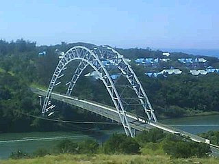
Port Shepstone is a large town situated on the mouth of the Mzimkhulu River, the largest river on the KwaZulu-Natal South Coast of South Africa. It is located halfway between Hibberdene and Margate and is positioned 120 km south of Durban. It serves as the administrative, educational, industrial and commercial centre for southern Natal.
Port Edward is a small resort town situated on the south coast of KwaZulu-Natal in South Africa and lies on the border between KwaZulu-Natal and the Eastern Cape. It is situated on the R61 road between Port Shepstone and Lusikisiki.

Ramsgate is a village on the south coast of KwaZulu-Natal in South Africa, just southwest of Margate. Ramsgate is located on the mouth of a river known by the Zulu name Bilanhlolo for the bubbles caused by strong currents making it look like the water is boiling. In 1922, there was only one person living there, Paul Buck, a painter and violin maker and he called the place Blue Lagoon.

Umzumbe is a seaside resort situated at the mouth of the Mzumbe River (bad kraal) in KwaZulu-Natal, South Africa. The name of the river is derived from a band of Hlongwa cannibals who occupied the valley. The Hlongwa was almost wiped out by the Zulu king Shaka in 1828.

Uvongo is a seaside resort town situated along the KwaZulu-Natal South Coast at the mouth of the Vungu River in KwaZulu-Natal, South Africa. Situated 4 kilometres north of Margate, Uvongo is the largest upmarket residential area on the Lower South Coast.

The R61 is a long provincial route in South Africa that connects Beaufort West with Port Shepstone via Graaff-Reinet, Komani, Mthatha and Port Edward.

The N2 is a national route in South Africa that runs from Cape Town through George, Gqeberha, East London, Mthatha, Port Shepstone and Durban to Ermelo. It is the main highway along the Indian Ocean coast of the country. Its current length of 2,255 kilometres (1,401 mi) makes it the longest numbered route in South Africa.

Southbroom is a coastal village on the South Coast of the KwaZulu-Natal province of South Africa situated approximately halfway between Port Shepstone – 23 km (14 mi) and Port Edward – 18 km (11 mi).
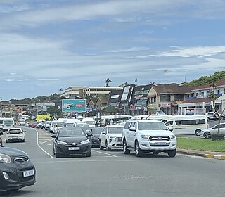
Shelly Beach is a coastal resort town on the South Coast of the KwaZulu-Natal province of South Africa, located approximately halfway between Margate and Port Shepstone.
Trafalgar is a seaside resort village in Ugu District Municipality in the KwaZulu-Natal province of South Africa. Trafalgar is on the north bank of the Mpenjati river which enters the Indian Ocean at the Mpenjati Nature Reserve. The town is located in lush coastal forest, sitting on a small rise overlooking the beach.
Gamalakhe is a township situated about 6 km (4 mi) inland on the South Coast of KwaZulu-Natal Province, South Africa.
The KwaZulu-Natal South Coast is a region along the southern stretch of coastline of KwaZulu-Natal, South Africa, south of the coastal city of Durban.
Oslo Beach is a small coastal village located along the South Coast of KwaZulu-Natal, South Africa and forms part of the coastal town of Port Shepstone.
Manaba Beach is a small coastal town on the South Coast of the KwaZulu-Natal province of South Africa, located approximately 2 kilometres north of the Margate CBD and 13 kilometres south of Port Shepstone. The name ‘Manaba’ translates to 'ease and relaxation' in the Zulu language.
Leisure Bay is a small coastal village located on the Lower South Coast of KwaZulu-Natal in South Africa.
St Michael's-on-Sea is a small seaside village located on the South Coast of KwaZulu-Natal, South Africa, between Uvongo and Shelly Beach.

Marina Beach is a coastal village and resort on the South Coast of the KwaZulu-Natal province of South Africa, approximately 32 kilometres (20 mi) south-west of Port Shepstone and 19 kilometres (12 mi) north-east of Port Edward. It lies on the mouth of the Kaba River between Southbroom and San Lameer.

Izotsha is a small rural settlement on the South Coast of the KwaZulu-Natal province of South Africa, just inland from Shelly Beach and approximately 7 kilometres south-west of Port Shepstone. The name ‘Izotsha’ translates to 'it will burn’ in the Zulu language.

