Marburg | |
|---|---|
 Marburg  Marburg | |
| Coordinates: 30°43′S30°23′E / 30.717°S 30.383°E | |
| Country | South Africa |
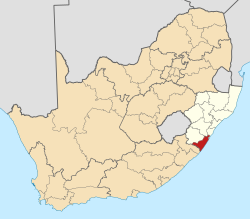
| Province | KwaZulu-Natal |
| District | Ugu |
| Municipality | Ray Nkonyeni |
| Main Place | Port Shepstone |
| Area | |
• Total | 1.5 km2 (0.6 sq mi) |
| Population (2011) [1] | |
• Total | 1,355 |
| • Density | 900/km2 (2,300/sq mi) |
| Racial makeup (2011) | |
| • Black African | 9.1% |
| • Coloured | 3.4% |
| • Indian/Asian | 87.0% |
| • White | 0.1% |
| • Other | 0.4% |
| First languages (2011) | |
| • English | 88.3% |
| • Zulu | 6.1% |
| • Xhosa | 2.0% |
| • Afrikaans | 1.9% |
| • Other | 1.7% |
| Time zone | UTC+2 (SAST) |
| PO box | 4252 |
Marburg is a settlement in the Ugu District Municipality in the KwaZulu-Natal province of South Africa, situated approximately 112 kilometres south-west of the city of Durban. Marburg was a Norwegian settlement given the name Marburg for a nearby German mission. [2] The Norwegian founders played a significant role in the development of Marburg and Port Shepstone, which it forms part of today. The British colonial government gave the settlers a free voyage to South Africa and also houses and 100 acres of land. Marburg was the only successful Scandinavian settlement in South Africa. [3]
Contents
Marburg was established in 1882 by Norwegian immigrants and was likely named after Marburg, a city 74 km north of Frankfurt in Germany. [4]