
KwaDukuza Local Municipality is one of four municipalities under iLembe District Municipality, KwaZulu-Natal, South Africa. As of 2022 it has a population of 324,912.

Hibiscus Coast Local Municipality was a local municipality in the province of KwaZulu-Natal in South Africa. It governed the Hibiscus Coast on the KwaZulu-Natal South Coast which attracts tourists from the province and other provinces as well as international tourists.
Abaqulusi Municipality is a local municipality within Zululand District Municipality, in the KwaZulu-Natal province of South Africa. It is named after the abaQulusi, a Zulu clan whose descendants live in the vicinities of Vryheid, Utrecht, Paulpietersburg and Louwsburg. They hailed from different origins but were unified by their allegiance to local Zulu royal homesteads.

uMngeni Municipality is a local municipality within the Umgungundlovu District Municipality, in the KwaZulu-Natal province of South Africa. The municipality is named after the uMngeni River that runs through the municipal area.

Maphumulo Local Municipality is an administrative area in the iLembe District of KwaZulu-Natal in South Africa. Maphumulo is an isiZulu name meaning "place of rest".

uMdoni Municipality is a local municipality within the Ugu District Municipality, in the KwaZulu-Natal province of South Africa. uMdoni is the isiZulu name for the indigenous forest waterberry plant.

Dannhauser Municipality is a local municipality within the Amajuba District Municipality, in the KwaZulu-Natal province of South Africa. The municipality is named after Renier Dannhauser, a German settler who in 1872 purchased four farms in the area from the Natal Government. The major economic sectors are agriculture and mining. Mining, however, is undergoing a movement away from large scale operations to smaller operations.

Umzimkhulu Municipality is a local municipality within the Harry Gwala District Municipality, in the KwaZulu-Natal province of South Africa. Umzimkhulu is an isiXhosa and isiZulu word meaning "big/great house". Prior to the Twelfth Amendment of the Constitution of South Africa in 2005, confirmed by the Thirteenth in 2007, it was part of the Eastern Cape.

Mtubatuba Municipality is a local municipality within the Umkhanyakude District Municipality, in the KwaZulu-Natal province of South Africa.

Jozini Municipality is a local municipality within the Umkhanyakude District Municipality, in the KwaZulu-Natal province of South Africa. Significant portions of the municipality have been neglected in terms of economic development. There is a great disparity between the level of service and infrastructure provision between settlement nodes, such as the towns of Mkuze and Jozini, and the surrounding rural areas. Most of the rural area is associated with a lack of development, poverty and poor service provision.

eDumbe Municipality is a local municipality within the Zululand District Municipality, in the KwaZulu-Natal province of South Africa. The municipality is named after the Dumbe mountain.

uMlalazi Local Municipality is an administrative area in the King Cetshwayo District of KwaZulu-Natal in South Africa. The municipality is named after the uMlalazi River.

uMuziwabantu Municipality is a local municipality within the Ugu District Municipality, in the KwaZulu-Natal province of South Africa. uMuziwabantu is an isiZulu word meaning "the people's home", or "a home with wide open doors where everyone is welcome". The main source of income for the area is derived from the municipality's extensive wattle, gum, pine and poplar plantations, and associated industries, including saw mills and furniture-making factories.
Nquthu Municipality is a local municipality within the Umzinyathi District Municipality, in the KwaZulu-Natal province of South Africa. Nquthu is an isiZulu word meaning "the back of the head".

Mthonjaneni is an administrative area in the King Cetshwayo District of KwaZulu-Natal in South Africa.

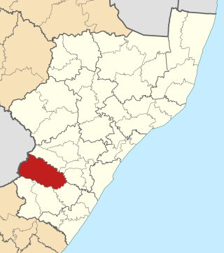
Ubuhlebezwe Municipality is a local municipality within the Harry Gwala District Municipality, in the KwaZulu-Natal province of South Africa. Ubuhlebezwe is an isiZulu word meaning "the beauty of the land". The name is derived from Alan Paton's novel, Cry, The Beloved Country.

Ingwe Local Municipality was an administrative area in the Harry Gwala District of KwaZulu-Natal in South Africa. Ingwe is an isiZulu name word that means leopard. The municipality was given the name because there were leopards in this area many years ago.

uMfolozi Local Municipality is a local municipality within the King Cetshwayo District Municipality of KwaZulu-Natal in South Africa. It is situated around the town of KwaMbonambi, to the north of Richard's Bay, stretching from the Indian Ocean to the edge of the Hluhluwe–Imfolozi Park.

Umvoti Municipality is a local municipality within the Umzinyathi District Municipality, in the KwaZulu-Natal province of South Africa.
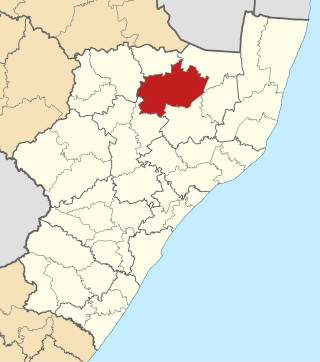
Dr Nkosazana Dlamini-Zuma Municipality is a local municipality within the Harry Gwala District Municipality, in the KwaZulu-Natal province of South Africa. It was established after the 2016 municipal elections by merging the Ingwe and Kwa Sani local municipalities.


