Mpofana Local Municipality

Last updated
Mpofana
Mpofana CoA.png
Map of KwaZulu-Natal with Mpofana highlighted (2011).svg
Location in KwaZulu-Natal
Country South Africa
Province KwaZulu-Natal
District uMgungundlovu
Seat Mooi River
Wards 4
Government
[1]
  Type Municipal council
  MayorXolani Magnificent Duma
Area
  Total1,820 km2 (700 sq mi)
Population
 (2011) [2]
  Total38,103
  Density21/km2 (54/sq mi)
Racial makeup (2011)
[2]
   Black African 92.1%
   Coloured 0.6%
   Indian/Asian 1.8%
   White 5.2%
First languages (2011)
[3]
   Zulu 87.0%
   English 7.0%
   Southern Ndebele 1.2%
  Other4.8%
Time zone UTC+2 (SAST)
Municipal codeKZN223

Mpofana Municipality (Lua error in Module:Lang at line 1422: attempt to concatenate a nil value.) is a local municipality within the Umgungundlovu District Municipality, in the KwaZulu-Natal province of South Africa.

Contents

Main places

The 2001 census divided the municipality into the following main places: [4]

PlaceCodeArea (km2)Population
Mooi River 50902 13.4213,408
Rosetta 50903 1.49299
Remainder of the municipality 50901 1,642.8523,104

Politics

The municipal council consists of ten members elected by mixed-member proportional representation. Five councillors are elected by first-past-the-post voting in five wards, while the remaining five are chosen from party lists so that the total number of party representatives is proportional to the number of votes received. In the election of 1 November 2021 the African National Congress (ANC) won a majority of seven seats on the council. The following table shows the results of the election. [5]

PartyWardListTotal
seats
Votes%SeatsVotes%Seats
African National Congress 5,25164.0455,50067.3927
Democratic Alliance 1,07813.1501,06513.0511
Economic Freedom Fighters 6648.10081610.0011
Inkatha Freedom Party 4235.1604775.8411
Independent candidates 4875.9400
Abantu Batho Congress 1732.1101772.1700
African Christian Democratic Party 600.730650.8000
African Mantungwa Community 490.600620.7600
National Freedom Party 140.1700
Total8,199100.0058,162100.00510
Valid votes8,19998.448,16297.95
Invalid/blank votes1301.561712.05
Total votes8,329100.008,333100.00
Registered voters/turnout16,76849.6716,76849.70

Related Research Articles

<span class="mw-page-title-main">Pixley ka Seme Local Municipality</span> Local municipality in Mpumalanga, South Africa

Pixley Ka Seme Municipality is a local municipality within the Gert Sibande District Municipality, in the Mpumalanga province of South Africa. Volksrust is the seat of the municipality.

uMngeni Local Municipality Local municipality in KwaZulu-Natal, South Africa

uMngeni Municipality is a local municipality within the Umgungundlovu District Municipality, in the KwaZulu-Natal province of South Africa. The municipality is named after the uMngeni River that runs through the municipal area.

<span class="mw-page-title-main">Newcastle Local Municipality</span> Local municipality in KwaZulu-Natal, South Africa

Newcastle Municipality is a local municipality within the Amajuba District Municipality, in the KwaZulu-Natal province of South Africa.

<span class="mw-page-title-main">Endumeni Local Municipality</span> Local municipality in KwaZulu-Natal, South Africa

Endumeni Municipality is a local municipality within the Umzinyathi District Municipality, in the KwaZulu-Natal province of South Africa. Endumeni is an isiZulu word meaning "a place of thunderstorm". The municipality shares its name with the Endumeni hill.

<span class="mw-page-title-main">Kwa Sani Local Municipality</span> Former local municipality in KwaZulu-Natal, South Africa

Kwa Sani Local Municipality was an administrative area in the Harry Gwala of KwaZulu-Natal in South Africa.

<span class="mw-page-title-main">Maphumulo Local Municipality</span> Local municipality in KwaZulu-Natal, South Africa

Maphumulo Local Municipality is an administrative area in the iLembe District of KwaZulu-Natal in South Africa. Maphumulo is an isiZulu name meaning "place of rest".

eMadlangeni Local Municipality Local municipality in KwaZulu-Natal, South Africa

eMadlangeni Municipality, previously known as Utrecht Municipality, is a local municipality within the Amajuba District Municipality, in the KwaZulu-Natal province of South Africa.

uMdoni Local Municipality Area in KwaZulu-Natal, South Africa

uMdoni Municipality is a local municipality within the Ugu District Municipality, in the KwaZulu-Natal province of South Africa. uMdoni is the isiZulu name for the indigenous forest waterberry plant.

<span class="mw-page-title-main">Dannhauser Local Municipality</span> Local municipality in KwaZulu-Natal, South Africa

Dannhauser Municipality is a local municipality within the Amajuba District Municipality, in the KwaZulu-Natal province of South Africa. The municipality is named after Renier Dannhauser, a German settler who in 1872 purchased four farms in the area from the Natal Government. The major economic sectors are agriculture and mining. Mining, however, is undergoing a movement away from large scale operations to smaller operations.

<span class="mw-page-title-main">Phumelela Local Municipality</span> Local municipality in Free State, South Africa

Phumelela Municipality is a local municipality within the Thabo Mofutsanyane District Municipality, in the Free State province of South Africa. Phumelela means "to succeed" in isiZulu.

<span class="mw-page-title-main">Mtubatuba Local Municipality</span> Local municipality in KwaZulu-Natal, South Africa

Mtubatuba Municipality is a local municipality within the Umkhanyakude District Municipality, in the KwaZulu-Natal province of South Africa.

eDumbe Local Municipality Local municipality in KwaZulu-Natal, South Africa

eDumbe Municipality is a local municipality within the Zululand District Municipality, in the KwaZulu-Natal province of South Africa. The municipality is named after the Dumbe mountain.

<span class="mw-page-title-main">Umzumbe Local Municipality</span> Local municipality in KwaZulu-Natal, South Africa

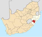
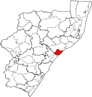
Umzumbe Municipality is a local municipality within the Ugu District Municipality, in the KwaZulu-Natal province of South Africa. The municipality is named after the Umzumbe River. Towns within the municipal boundaries include Friedenau, KwaDweshula, St Faith’s, and Umzumbe.

<span class="mw-page-title-main">Richmond Local Municipality</span> Local municipality in KwaZulu-Natal, South Africa

Richmond Municipality is a local municipality within the Umgungundlovu District Municipality, in the KwaZulu-Natal province of South Africa.

<span class="mw-page-title-main">Impendle Local Municipality</span> Local municipality in KwaZulu-Natal, South Africa

Impendle Municipality is a local municipality wirhin the Umgungundlovu District Municipality, in the KwaZulu-Natal province of South Africa. During the 18th century, the Griquas ("Abatwas") used to hide in the mountain in the area because they were accused of stealing livestock from the farmers who decided to fight the Griquas in order to protect their livestock. The Griquas used war spears, and this conflict was called "an outside war", i.e. impiyasendle or impiendle.

<span class="mw-page-title-main">Mthonjaneni Local Municipality</span> Local municipality in KwaZulu-Natal, South Africa

Mthonjaneni is an administrative area in the King Cetshwayo District of KwaZulu-Natal in South Africa.

<span class="mw-page-title-main">Mandeni Local Municipality</span> Local municipality in KwaZulu-Natal, South Africa

Mandeni Local Municipality is an administrative area in the iLembe District of KwaZulu-Natal in South Africa.

<span class="mw-page-title-main">Ndwedwe Local Municipality</span> Local municipality in KwaZulu-Natal, South Africa

Ndwedwe Local Municipality is an administrative area in the iLembe District of KwaZulu-Natal in South Africa.

<span class="mw-page-title-main">Ubuhlebezwe Local Municipality</span> Local municipality in KwaZulu-Natal, South Africa

Ubuhlebezwe Municipality is a local municipality within the Harry Gwala District Municipality, in the KwaZulu-Natal province of South Africa. Ubuhlebezwe is an isiZulu word meaning "the beauty of the land". The name is derived from Alan Paton's novel, Cry, The Beloved Country.

The Mpofana Local Municipality is a local municipality within the Umgungundlovu District Municipality, in the KwaZulu-Natal province of South Africa. The council consists of ten members elected by mixed-member proportional representation. Five councillors are elected by first-past-the-post voting in five wards, while the remaining five are chosen from party lists so that the total number of party representatives is proportional to the number of votes received. In the election of 1 November 2021 the African National Congress (ANC) won a majority of seven seats on the council.

References

  1. "Contact list: Executive Mayors". Government Communication & Information System. Archived from the original on 14 July 2010. Retrieved 22 February 2012.
  2. 1 2 "Statistics by place". Statistics South Africa. Retrieved 27 September 2015.
  3. "Statistics by place". Statistics South Africa. Retrieved 27 September 2015.
  4. Lookup Tables - Statistics South Africa
  5. "Election Result Table for LGE2021 — Mpofana". wikitable.frith.dev. Retrieved 2021-11-28.

29°09′33″S29°57′45″E / 29.15917°S 29.96250°E / -29.15917; 29.96250