King Cetshwayo District Municipality

Last updated
King Cetshwayo
uThungulu
Uthungulu CoA.png
Map of KwaZulu-Natal with King Cetshwayo highlighted (2016).svg
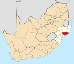
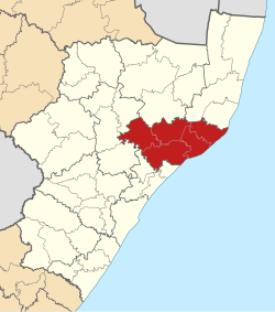
Location in South Africa
Country South Africa
Province KwaZulu-Natal
Seat Richards Bay
Local municipalities
Government
[1]
  Type Municipal council
  MayorVacant
Area
  Total8,213 km2 (3,171 sq mi)
Population
 (2011) [2]
  Total907,519
  Density110/km2 (290/sq mi)
Racial makeup (2011)
[2]
   Black African 94.4%
   Coloured 0.6%
   Indian/Asian 1.6%
   White 3.2%
First languages (2011)
[3]
   Zulu 89.1%
   English 5.1%
   Afrikaans 2.3%
   Southern Ndebele 1.3%
  Other2.2%
Time zone UTC+2 (SAST)
Municipal codeDC28

King Cetshwayo District Municipality (formerly Uthungulu District Municipality [4] ) is one of the 11 district municipalities ("districts") of KwaZulu-Natal province in South Africa. The seat of the district is Richards Bay. The majority of its 885 944 people speak Zulu (2001 Census). The district code is DC28. It is named after Cetshwayo kaMpande, King of the Zulu Kingdom from 1872 to 1879, who led his nation to victory against the British in the Battle of Isandlwana.

Contents

Geography

Neighbours

King Cetshwayo District is surrounded by:

Local municipalities

The district contains the following local municipalities:

Local municipalityPopulation%
uMhlathuze 289 18732.64%
Umlalazi 221 07724.95%
Nkandla 133 59615.08%
Mbonambi 106 94912.07%
Ntambanana 84 7729.57%
Mthonjaneni 50 3825.69%

Demographics

The following statistics are from the South African National Census of 2011.

LanguagePopulation%
Zulu 797 54589.11%
English 45 5735.09%
Afrikaans 20 2902.27%
Ndebele 11 8011.32%
Tswana 5 7710.64%
Northern Sotho 1 9890.22%
isiXhosa 1 9670.22%
Other 3 4820.39%
Sotho 1 2380.14%
Tsonga 7300.08%
Swati 7090.08%
Venda 4520.05%

Gender

GenderPopulation%
Female480 12252.90%
Male427 39747.10%

Ethnic group

Ethnic groupPopulation%
Black African856 99794.43%
White29 3753.24%
Indian/Asian14 3621.61%
Coloured5 0270.55%

Age

AgePopulation%
000 - 004105 29211.88%
005 - 009117 33813.24%
010 - 014116 67813.17%
015 - 019111 82812.62%
020 - 02483 1469.39%
025 - 02970 0387.91%
030 - 03453 8296.08%
035 - 03949 6675.61%
040 - 04442 5684.80%
045 - 04932 5523.67%
050 - 05426 9913.05%
055 - 05918 6082.10%
060 - 06418 5502.09%
065 - 06913 0651.47%
070 - 07411 9701.35%
075 - 0796 0940.69%
080 - 0844 9040.55%
085 - 0891 4580.16%
090 - 0947670.09%
095 - 0994750.05%
100 plus1260.01%

Sister City

King Cetshwayo District is officially a sister city of Milwaukee, Wisconsin, USA ( Flag of the United States.svg Milwaukee, United States). The joining of the two cities was largely enacted from legislation in Wisconsin in collaboration with the Africa Urban Poverty Alleviation Program. In 2009, Sister Cities International launched the Africa Urban Poverty Alleviation Program, a three-year project to alleviate poverty in 25 African cities (including King Cetshwayo District) through water, sanitation and health initiatives. Milwaukee will collaborate with their African counterparts to identify and address the most critical problems in these sectors, which form barriers to sustained development in urban areas. This project is funded by a $7.5 million grant from the Bill & Melinda Gates Foundation. The program is cited to end in middle of the year 2012.

Politics

Election results

Election results for uThungulu (King Cetshwayo District) in the South African general election, 2004.

PartyVotes%
Inkhata Freedom Party 150 18759.57%
African National Congress 76 50330.34%
Democratic Alliance 14 5565.77%
African Christian Democratic Party 3 5531.41%
United Democratic Movement 1 7910.71%
Freedom Front Plus 7730.31%
Independent Democrats 6660.26%
New National Party 6330.25%
Azanian People's Organisation 5910.23%
Pan African Congress 4190.17%
SOPA 3060.12%
CDP 3040.12%
United Christian Democratic Party 2830.11%
KISS 2530.10%
Minority Front 2490.10%
UF 2410.10%
EMSA 2070.08%
PJC 2000.08%
NA 1720.07%
TOP 1560.06%
NLP 960.04%
Total252 139100.00%

See also

Related Research Articles

<span class="mw-page-title-main">KwaZulu-Natal</span> Province in South Africa

KwaZulu-Natal is a province of South Africa that was created in 1994 when the government merged the Zulu bantustan of KwaZulu and Natal Province.

<span class="mw-page-title-main">Richards Bay</span> Place in KwaZulu-Natal, South Africa

Richards Bay is a city in KwaZulu-Natal, South Africa. It is situated on a 30 square kilometre lagoon of the Mhlatuze River, which makes it one of the country's largest harbours. Richards Bay also has the deepest natural harbour on the African continent.

<span class="mw-page-title-main">Nkandla, KwaZulu-Natal</span> Place in KwaZulu-Natal, South Africa

Nkandla is a town in the uThungulu district of KwaZulu-Natal, South Africa. It is the seat of the Nkandla Local Municipality, and the district in which the residence of the former President of South Africa, Jacob Zuma, is located. The residence is located 40 kilometres to the south of the town of Nkandla, beyond the Nkandla Forest and on the road to Kranskop.

<span class="mw-page-title-main">Umgungundlovu District Municipality</span> District municipality in KwaZulu-Natal, South Africa

uMgungundlovu is one of the 11 district municipalities ("districts") of KwaZulu-Natal province. The seat of uMgungundlovu is Pietermaritzburg. The majority of its 1 million+ residents speak Zulu. The district code is DC22.

iLembe District Municipality District municipality in KwaZulu-Natal, South Africa

iLembe is one of the 11 district municipalities of KwaZulu-Natal province in South Africa. The seat of iLembe is KwaDukuza. The majority (82%) of its 606,809 people speak isiZulu as their first language. The district code is DC29. It was formerly named the King Shaka District Municipality.

<span class="mw-page-title-main">Umzinyathi District Municipality</span> District municipality in KwaZulu-Natal, South Africa

The Umzinyathi District Municipality is one of the 11 districts of the KwaZulu-Natal province of South Africa. Its seat is Dundee. As of 2011, a majority of its 456,452 inhabitants spoke isiZulu. The district code is DC24

<span class="mw-page-title-main">Zululand District Municipality</span> District municipality in KwaZulu-Natal, South Africa

The Zululand District Municipality is one of the 11 districts of the KwaZulu-Natal province of South Africa. Its seat is Ulundi. As of 2011, a majority of its 803,575 inhabitants spoke isiZulu. The district code is DC26.

<span class="mw-page-title-main">Amajuba District Municipality</span> District municipality in KwaZulu-Natal, South Africa

The Amajuba District Municipality is one of the 11 districts of the KwaZulu-Natal province of South Africa. Its seat is Newcastle. As of 2011, a majority of its 468,040 inhabitants isiZulu. The district code is DC25

<span class="mw-page-title-main">Uthukela District Municipality</span> District municipality in KwaZulu-Natal, South Africa

The uThukela District Municipality is one of the 11 districts of the KwaZulu-Natal province of South Africa. Its seat is Ladysmith. As of 2011, a majority of its 668,848 inhabitants spoke isiZulu. The district code is DC23.

<span class="mw-page-title-main">Harry Gwala District Municipality</span> District municipality in KwaZulu-Natal, South Africa

The Harry Gwala District Municipality, formerly the Sisonke District Municipality, is one of the 11 districts of the KwaZulu-Natal province of South Africa. The seat is Ixopo. The majority of its 298,392 inhabitants spoke isiZulu as of 2011. The district code is DC43. The district's name was changed in November 2015 in honor of African National Congress leader Harry Gwala.

<span class="mw-page-title-main">Umkhanyakude District Municipality</span> District municipality in KwaZulu-Natal, South Africa

The uMkhanyakude District Municipality is the northernmost of the 11 districts of the KwaZulu-Natal province of South Africa. Its seat is Mkuze. It is a very rural district, the largest town being Mtubatuba in the south, with Hluhluwe, Mkuze, Jozini, Kwangwanase and Ingwavuma further to the north. The majority of its 573,353 inhabitants spoke isiZulu as of 2001. The district code is DC27.

<span class="mw-page-title-main">Nkandla Local Municipality</span> Local municipality in KwaZulu-Natal, South Africa

Nkandla Local Municipality is an administrative area in the King Cetshwayo District of KwaZulu-Natal province in South Africa. The town of Nkandla is the home town of the former President of South Africa, Jacob Zuma.

uMhlathuze Local Municipality Local municipality in KwaZulu-Natal, South Africa

uMhlathuze Local Municipality is an administrative area in the King Cetshwayo District Municipality of KwaZulu-Natal in South Africa. The municipality is named after the Mhlatuze River.

<span class="mw-page-title-main">Msinga Local Municipality</span> Local municipality in KwaZulu-Natal, South Africa

Msinga Municipality is a local municipality within the Umzinyathi District Municipality, in the KwaZulu-Natal province of South Africa. Msinga is an isiZulu word meaning "a current in the sea where air movement causes ripples on top of the water surface and ends up influencing the nearby climatic conditions through its breeze". The municipality is largely located in deep gorges of the Tugela and Buffalo rivers, isolated from the immediate surrounding municipal areas. The population dynamics result in a growing rural area and a declining urban area in the municipality, contrary to most other areas in the country. This can be attributed to the fact that the urban areas of municipality are very small and are unable to provide the normal range of goods and services provided in urban areas.

<span class="mw-page-title-main">Jozini Local Municipality</span> Local municipality in KwaZulu-Natal, South Africa

Jozini Municipality is a local municipality within the Umkhanyakude District Municipality, in the KwaZulu-Natal province of South Africa. Significant portions of the municipality have been neglected in terms of economic development. There is a great disparity between the level of service and infrastructure provision between settlement nodes, such as the towns of Mkuze and Jozini, and the surrounding rural areas. Most of the rural area is associated with a lack of development, poverty and poor service provision.

uMlalazi Local Municipality Local municipality in KwaZulu-Natal, South Africa

uMlalazi Local Municipality is an administrative area in the King Cetshwayo District of KwaZulu-Natal in South Africa. The municipality is named after the uMlalazi River.

<span class="mw-page-title-main">Mthonjaneni Local Municipality</span> Local municipality in KwaZulu-Natal, South Africa

Mthonjaneni is an administrative area in the King Cetshwayo District of KwaZulu-Natal in South Africa.

<span class="mw-page-title-main">Ntambanana Local Municipality</span> Local municipality in KwaZulu-Natal, South Africa

Ntambanana Local Municipality was a local municipality within the uThungulu District of KwaZulu-Natal in South Africa. In 2016, the municipality was dissolved and its territory divided between Mthonjaneni Local Municipality, uMhlathuze Local Municipality and uMfolozi Local Municipality.

uMfolozi Local Municipality Local municipality in KwaZulu-Natal, South Africa

uMfolozi Local Municipality is a local municipality within the King Cetshwayo District Municipality of KwaZulu-Natal in South Africa. It is situated around the town of KwaMbonambi, to the north of Richard's Bay, stretching from the Indian Ocean to the edge of the Hluhluwe–Imfolozi Park.

Thembeka Vuyisile Buyisile Mchunu is a South African politician from KwaZulu-Natal serving as a Member of the National Assembly of South Africa since 2019. A member of the African National Congress, she served as the Executive Mayor of the Uthungulu District Municipality from 2011 to 2016. She is married to Senzo Mchunu, the current Minister of Water and Sanitation and the former premier of KwaZulu-Natal.

References

  1. "King Cetshwayo District Municipality - South African Government". www.gov.za. Retrieved 2023-09-29.
  2. 1 2 "Statistics by place". Statistics South Africa. Retrieved 27 September 2015.
  3. "Statistics by place". Statistics South Africa. Retrieved 27 September 2015.
  4. Khoza, Amanda (27 July 2016). "Zwelithini welcomes renaming of uThungulu to King Cetshwayo District Municipality". News24. Retrieved 3 September 2016.

28°44′S32°05′E / 28.733°S 32.083°E / -28.733; 32.083