Pietermaritzburg (; is the capital and second-largest city in the province of KwaZulu-Natal, South Africa after Durban. It was named in 1838 and is currently governed by the Msunduzi Local Municipality. The town was named after King Dingane's royal homestead uMgungundlovu. Pietermaritzburg is popularly called Maritzburg in Afrikaans and is often informally abbreviated to PMB. It is a regionally important industrial hub, producing aluminium, timber and dairy products, as well as the main economic hub of uMgungundlovu District Municipality. The public sector is a major employer in the city due to local, district and provincial government offices located here.
Kokstad is a town in the Harry Gwala District Municipality of KwaZulu-Natal Province, South Africa. Kokstad is named after the Griqua chief Adam Kok III who settled here in 1863. Kokstad is the capital town of the East Griqualand region, as it is also the biggest town in this region. It was built around Mount Currie, a local mountain range, by the city's founder Adam Kok III, for whom the town is named. Stad is the Dutch and Afrikaans word for "city".
KwaDukuza, previously known as Stanger, is a city in KwaZulu-Natal, South Africa. In 2006, the municipal name was changed to KwaDukuza, but the Zulu people in the area called it "Dukuza" well before then.

Port Shepstone is a large town situated on the mouth of the Mzimkhulu River, the largest river on the KwaZulu-Natal South Coast of South Africa. It is located halfway between Hibberdene and Margate and is positioned 120 km south of Durban. It serves as the administrative, educational, industrial and commercial centre for southern Natal.
Port Edward is a small resort town situated on the south coast of KwaZulu-Natal in South Africa and lies on the border between KwaZulu-Natal and the Eastern Cape. It is situated on the R61 road between Port Shepstone and Lusikisiki.
Harding is a town situated in the Mzimkulwana River valley, Ugu District Municipality of KwaZulu-Natal, South Africa

Umkomaas, also known by its official name eMkhomazi, is a small coastal village on the subtropical South Coast of KwaZulu-Natal, South Africa was formed when a harbour was built in 1861 to export sugar. The village rests beside the mouth of the navigable uMkhomazi River, also known as the Mkhomazi or Umkomaas. With the successful dredging of Durban harbour's sandbar and arrival of the railway, like Port Shepstone, the harbour fell into disuse, but the village came to life. It is administered as eMkhomazi Area, together with the nearby areas of Craigieburn, Clansthal, Crowder, Amahlongwa and Hull Valley as part Ward 99 in the eThekwini Metropolitan Municipality
Mkuze, also named Mkhuze or uMkhuze is a small town in Northern KwaZulu-Natal, South Africa. It is located approximately 350 km from the city of Durban. It is along the N2 road en route to Johannesburg, Eswatini and Mozambique; between the Mkuze River and Intaba Yemikhovu. Mkuze is some distance from other small towns such as Hluhluwe (50 km), Nongoma (76 km), Pongola (65 km), and Jozini (25 km). Mkuze is the seat of Umkhanyakude District Municipality.

Amanzimtoti, locally nicknamed Toti, and officially renamed to eManzimtoti, is a coastal town just south of Durban in KwaZulu-Natal, South Africa. Situated along the Sapphire Coast, the town is well known for its warm climate and numerous beaches, and is a popular tourist destination, particularly with surfers.
Pinetown is a city that forms part of the eThekwini Metropolitan Municipality, based just inland from Durban in KwaZulu-Natal, South Africa. The town is situated 16 km north-west of Durban and 64 km south-east of Pietermaritzburg.
Westville is an area in KwaZulu-Natal, South Africa, and is just west and 10 km inland from the Durban CBD. It was a formerly independent municipality however it became part of the eThekwini Metropolitan Municipality in 2002.
Inanda or eNanda is a township in KwaZulu-Natal, South Africa that is situated 21 km north-west of Durban. It forms part of eThekwini, the Greater Durban Metropolitan Municipality. Populated primarily by Zulu-speaking Black Africans, Inanda is the home of John Langalibalele Dube, first President of the African National Congress (ANC), a former residence and base of operations of Mahatma Gandhi, and the birthplace of the syncretic Nazareth Baptist Church

oThongathi, previously and still commonly known as Tongaat, is a town in KwaZulu-Natal, South Africa, about 40 kilometres (25 mi) north of Durban and 28 kilometres (17 mi) south of KwaDukuza. It now forms part of eThekwini Metropolitan Municipality, or the Greater Durban area. The area is home to the oldest Indian community in South Africa, having been where the first indentured Indian laborers settled in 1860 to work in the sugar-cane plantations. Much of the architectural style in the town was the work of Ivan Mitford-Barberton, and many buildings are in the Cape Dutch style of architecture.
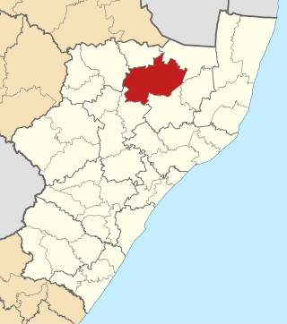
Abaqulusi Municipality is a local municipality within Zululand District Municipality, in the KwaZulu-Natal province of South Africa. It is named after the abaQulusi, a Zulu clan whose descendants live in the vicinities of Vryheid, Utrecht, Paulpietersburg and Louwsburg. They hailed from different origins but were unified by their allegiance to local Zulu royal homesteads.

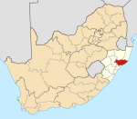
Matatiele Municipality is a local municipality within the Alfred Nzo District Municipality, in the Eastern Cape province of South Africa. It adjoins Lesotho to the north, Elundini to the south-west, and Greater Kokstad to the east and its 4,352 km² makes the Matatiele Municipality largest of four municipalities in the district at almost half of its geographical area. According to the South African National Census of 2011, its 203,483 residents and 49,527 households makes Matatiele Municipality the second largest populated area in the Alfred Nzo District Municipality behind Mbizana.

Mtwalume, also known as Umtalumi, is a settlement in Ugu District Municipality in the KwaZulu-Natal province of South Africa.
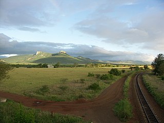
Impendle is a town in Umgungundlovu District Municipality in the KwaZulu-Natal province of South Africa.
Izingolweni or eZinqoleni is a town in Ugu District Municipality in the KwaZulu-Natal province of South Africa. It was founded in the 1870s as a police and administration post. The name comes from the Zulu language word for "place with very shallow holes." Izingolweni also consists of a school called Izingolweni Primary which is rumored that it was built by the community. This very school is the center of excellence in the place. It is very exceptional and produces very fine learners each year.
Mpumalanga, also widely known as Hammarsdale, is a township located in the eThekwini Metropolitan Municipality in the KwaZulu-Natal province of South Africa. It is situated some 10 km south-south-east of Cato Ridge and some 50 km west of Durban. Derived from Zulu, the name means 'sunrise', 'the sun comes out'.

Amandawe also known as Amandawe Mission, or often informally abbreviated as A.M.A or A.M is a small township in the KwaZulu-Natal South Coast region of South Africa. The area is mostly populated with Black Africans.